Details: Hidden Lake Overlook and Hidden Lake 
Distance: 2.6 - 5.2 miles (round trip)
Glacier National Park, near West Glacier in Glacier Natl Park, MT
Hike Facts
- Distance: 2.6 - 5.2 miles (round trip)
- Elevation: 6,646-ft. - 7,170-ft.
- Elevation Gain: 529-ft.
- Difficulty: easy-moderate
- Trail Highlights: See Trail Intro
- Basecamp(s): West Glacier / St Mary
- Region: Glacier Natl Park, MT
Nonstop, panoramic views of the high peaks and alpine meadows around Logan Pass and a stunning overlook above Hidden Lake Basin make this one of the most popular outings in Glacier National Park. Extend the hike by visiting beautiful Hidden Lake.
Trailhead to Hidden Lake Overlook

Distance from Trailhead: 2.6 miles (round trip)
Ending/Highest Elevation: 7,170-ft.
Elevation Gain: 529-ft.
The trail to the Hidden Lake Overlook begins behind the Visitor Center (west side) at Logan Pass (see driving directions below). From the Visitor Center the paved trail heads west on easy grades through alpine meadows. The Garden Wall, a high ridge punctuated with distinctive peaks, fills the skyline to the north of Logan Pass. Oberlin Mountain (8,180-ft.) and Clements Mountain (8,760-ft.) tower above the pass to the west/northwest while Reynolds Mountain (9,125-ft.) and Heavy Runner Mountain (8,016) dominate the view to the south. Tiny wildflowers fill the meadows after the snow melts.
At 0.1 miles the paved path gives way to a boardwalk. The boardwalk ascends on moderate to moderately-steep grades through marshy meadows were a profusion of wildflower grow after the snow melts. Please stay on the boardwalk.
Soon the board walks curves to the southwest. After a half mile the boardwalk climbs a series of stair and ends. At the end of the boardwalk the grade abates as the dirt/gravel trail traverse the alpine meadows beneath the west facing slopes of Clements Mountain.
At 0.7 miles the ascent resumes on moderate grades as the trail climbs to a bench. A few waterfalls tumble down the slopes above the trail. Once atop the bench the grade eases as bit as the path travel along a moraine extending east from Clements Mountain.
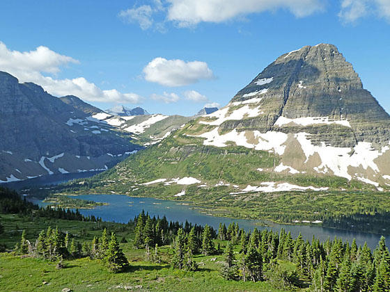
At 1.0 mile the trail dips into a pretty basin and passes a few shallow tarns. Clements Mountain towers overhead. Soon the trail climbs out of the basin and crests the saddle on the ridge separating the Logan Pass area from Hidden Lake Basin. The saddle is along the Continental Divide so all the water on the west side of the saddle eventually flows to the Pacific Ocean. Along this section of the trail views open to Bearhat Mountain (8,684-ft.). Edwards Mountain and Gunsight Mountain rise in the distance to the west. The Sperry Glacier clings to the slopes of Gunsight Mountain to the south.
An easy descent from the saddle leads to the overlook above Hidden Lake (6,375-ft.). Bearhat Mountain towers above the west side of the boomerang-shaped lake. Mount Cannon (8,952-ft.) rises to the northwest while ridges extending from Reynolds Mountain rim the basin to the south and east. Mount Brown and Stanton Mountain rise in the distance to the west between Bearhat and Mount Cannon.
The overlook can get quite crowded during the height of the season. Get an early start to avoid the worst of the crowds. Mountain goats frequent the overlook. Please keep your distance.
Overlook to Hidden Lake
Distance from Trailhead: 5.2 miles (round trip)
Ending/Highest Elevation: 6,375-ft.
Elevation Gain: -795-ft.
From the overlook the trail to Hidden Lake descends on easy grades along the south facing slopes of Clements Mountain. Here we have more fine views of Mount Brown and Stanton Mountain to the west. Ledges and large boulders along the trail offer nice perches for enjoying the views of the high peaks ringing the Hidden Lake basin.
At 1.7 miles the trail starts dropping through rocky meadows on moderately-steep grades. After half a mile the descent steepens. A few switchbacks facilitate the drop down the rocky trail. At 2.3 miles the meadows give way to scatter trees and the views become somewhat restricted.
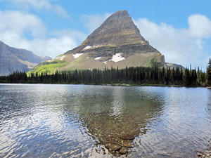
Reach a small beach along the north shore of Hidden Lake (6,375-ft.) at 2.6 miles. Here lovely views stretch to Reynolds Mountain and the high cliffs rimming the south and east side of the lake. Bearhat Mountain looms overhead. Short spur trails lead to the pretty outlet stream and nice areas along the shore to relax and take in the views.
When you are done lazing around the lake and taking in the views, retrace your steps to the trailhead.
Note: At times the Park Service closes the trail to Hidden Lake due to bear activity.
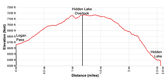
Elevation Profile
Driving Directions
From St Mary, MT: From the intersection of Highway 89 and the Going-to-the-Sun Road in St. Mary, drive west on the Going-to-the-Sun Road for 18 miles and then turn left into the Logan Pass Parking area. The parking area fills early. A better option is to drive 0.5 miles up the Going-to-the-Sun Road and turn right into the St. Mary Visitor Center. Park and take the shuttle bus to the pass.
From West Glacer, MT: From the junction of US-2 and the Going-to-the-Sun Road, turn northwest on the Going-to-the-Sun Road and follow the road 2.0 miles to a junction with the Camas Road leading to the Apgar Visitor Center. Turn right to continue on the Going-to-the-Sun Road. Follow the road for 30 miles and then turn right into the Logan Pass Parking area. The parking lot at Logan Pass fills early. A better option is to take the Shuttle Bus from the Apgar Visitor Center to the pass.
Trail Resources
Trail Intro / Trail Photo Gallery / Trail Map
Basecamp(s) Information:
West Glacier / St Mary
Region Information:
Glacier Natl Park, MT
Other Hiking Regions in:
Montana