Details: Gunsight Pass from Sperry Chalet 
Distance: 8.5 - 10.2 miles (round trip)
Glacier National Park, near West Glacier in Glacier Natl Park, MT
Hike Facts
- Distance: 8.5 - 10.2 miles (round trip)
- Elevation: 6,550-ft. - 7,050-ft.
- Elevation Gain: 1,770-ft.
- Difficulty: moderate-strenuous
- Trail Highlights: See Trail Intro
- Basecamp(s): West Glacier
- Region: Glacier Natl Park, MT
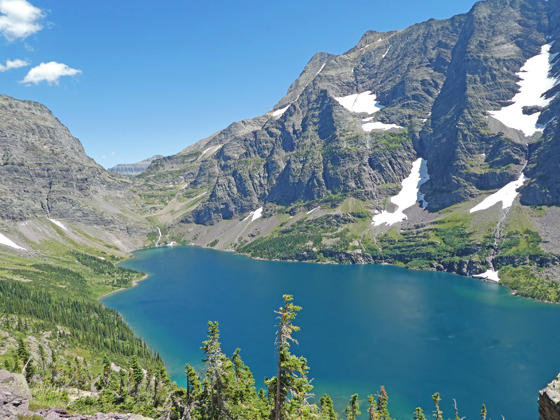
Cross two passes and travel above the shores of Lake Ellen Wilson on this superb hike with unsurpassed views of Mount Jackson, Gunsight Mountain, Lake Ellen Wilson and Gunsight Lake. Waterfalls, wildlife sighting and wildflowers add to the trail’s appeal.
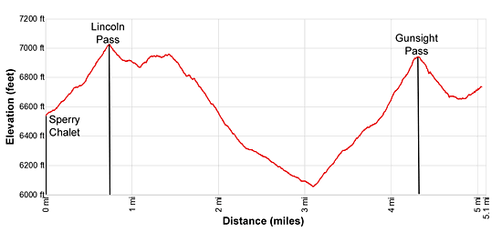
Sperry Chalet to Gunsight Pass
Elevation Profile: 6,650-ft. at Sperry Chalet
7,050-ft. at Lincoln Pass
6,050-ft. at the head of Lake Ellen Wilson
6,946-ft. at Gunsight Pass
The trail to the Sperry Chalet and campground starts at the Gunsight Pass Trailhead, located across from the Lake McDonald Lodge on the east side of the Going-to-the-Sun Road (see driving directions below). The first 6.2 miles of the hike follows the Gunsight Pass trail to the Sperry Chalet. See the Sperry Chalet trail description for more information about the section of the hike.
The mileage in this description assumes you are starting from the Sperry Chalet. If starting from the Sperry Campground subtract 0.3 miles from distances in the description.
From the Sperry Chalet, walk south on the Gunsight Pass trail toward Lincoln Pass. The trail starts climbing toward the pass on moderate to moderately-steep grades, passing the Sperry Campground at 0.3 miles and then a small tarn.
Beyond the tarn the trail ascends steep switchbacks through scree and then meadows to Lincoln Pass (7,050-ft.) at 0.7 miles. From the pass enjoy fine views of Mount Jackson (10,052-ft.) towering over the Lake Ellen Wilson Basin. To the west is Lake McDonald. Lincoln Peak rises along the ridge to the south.
After a short, steep descent from the pass the trail heads east on easy grades along talus slopes and rocky meadows. Soon the path winds around the end of a ridge and begins a traverse along a bench clad in meadows and rock outcroppings beneath the south-facing slopes of Peak 7,870-ft. Below the bench steep slopes drop over 2,300-ft. to the shores of Lincoln Lake. To the southwest are distance views of the Great Bear Wilderness.
At 1.45 miles the trail descends and soon curves to the left (northeast) around the end of a ridge. Here views open to beautiful Lake Ellen Wilson (5,929-ft.). Mount Jackson towers above the lake to the west. Gunsight Pass is now in sight, the saddle on the ridge above the head of the lake.
The descent steepens at 1.8 miles. The path now drops down talus slopes and meadows scattered with stunted trees on moderately-steep grades. Mount Jackson and Lake Ellen Wilson dominate the view to the east. Above the trail rugged Peak 9,258-ft., along the Gunsight Mountain ridge, competes for you attention.
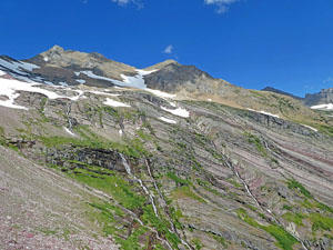
At 2.3 miles the grade moderates as the trail descends across avalanche slopes beneath Peak 9,258. A beautiful waterfall cascades down the rugged slopes beneath the peak. In season a profusion of wildflowers blanket the well-watered slopes along this section of the trail.
Cross the creek beneath the waterfall at 2.5 miles. At 2.6 miles pass the junction with the trail descending to the Lake Ellen Wilson Camping area. This 0.3 miles spur trail loses about 250-ft. as it descends to the lakeshore.
Beyond the junction the trail starts curving to the right (east) as it descends on moderate grades around the head of the basin. At 2.9 miles views open to the waterfall on the inlet stream at the head of the lake. Also now in view are the remains of glaciers on Mount Jackson’s northwest facing slope.
The beautiful waterfall on the inlet stream at the head of Lake Ellen Wilson gushes across a broad swath of the trail at 3.1 miles. Except for late in the season, expect to get your feet wet.
Beyond the falls the trail climbs switchbacks on moderately-steep to steep grades, gaining over 925-ft in 1.1 miles to Gunsight Pass (6,946-ft.). As you climb the trail crosses a few streams and enjoys great views of the waterfalls, fed by snow and glacial melt-water, spilling down Mount Jackson’s rugged slopes. To the west are ever improving views of the Gunsight Mountain massif.
Reach Gunsight Pass (6,946-ft.) at 4.25 miles. From the pass enjoy terrific views of the waterfalls and glaciers along Mount Jackson’s northwest-facing slopes. To the southwest views stretch down the length of Lake Ellen Wilson and beyond. The Gunsight Mountain massif dominates the view to the northwest. Atop the pass is a small rock shelter. Mountain goats are likely to be wandering around the pass.
A ridge extending from Mount Jackson restricts views to the northeast. I highly recommend dropping down the the pass gar enough to curve around the ridge. As you descend enjoy ever improving views of the Gunsight Mountain and the waterfalls tumbling down the massif’s colorful slopes. Soon views open to Fusillade Mountain rising to the northeast of Gunsight Mountain. In the distance, Going-to-the-Sun Mountain (9,642-ft.), Matahpi Peak (9,365-ft.) and Goat Mountain (8,826-ft.) tower above the north side of the Going-to-the-Sun Road.
At 4.6 miles Citadel Mountain (9,030-ft.), rising along the east side of the St. Mary Valley, and Gunsight Lake join the scene. The trail now curves to the right (east) around the end of the ridge. Here the grade briefly abates. The trail soon crosses a waterfall sliding down rock slabs above the trail and then climbs to a scenic overlook at 5.0 miles. Panoramic views stretch down the length of Gunsight Lake to the high peaks surrounding Going-to-the-Sun Mountain. Fusillade Peak towers above the far side of the lake. To the west are fine views of the Gunsight Pass massif.
Beyond this point the trail starts dropping in earnest to Gunsight Lake. Unless you are hiking all the way to the Jackson Glacier Overlook, turn around and retrace your steps to the Sperry Chalet, enjoying the great views in reverse on the trip back to the lodge.
Elevation Profile
Driving Directions
From West Glacier, MT: From the junction of US-2 and the Going-to-the-Sun Road, turn northwest on the Going-to-the-Sun Road and follow the road for 2.0 miles. Turn right at the junction with the Apgar Visitor Center to stay on Going-to-the-Sun Road. Continue for 8.9 miles. A crosswalk across the road signals the beginning of the Gunsight Pass/Sperry Chalet Trail on the right (east). Take the next left on an unmarked one-way road with a small wood building at the corner. Along this road you will find parking for the Lake McDonald Lodge and the trailhead. At the first intersection turn left on the road that runs parallel to the front of the Lodge. A short distance beyond take your next left on a one-way road heading back to the Going-to-the-Sun road. This road also includes parking for the Lake McDonald Lodge and the Gunsight Pass trail. Find a parking spot along the road and then walk the rest of the distance to the Going-to-the-Sun Road. Carefully cross the Going-to-the-Sun Road on the crosswalk. The trailhead for the Gunsight Pass trail to Snyder Lake and Sperry Chalet is on the east side of the road.
The parking lots around the Lake McDonald Lodge can be very congested. Typically in the morning, when people are checking out, you should be able to find a space. Alternative take the shuttle bus from the Apgar Visitor Center, a better option during the height of the summer when parking is limited.
Trail Resources
Trail Intro / Trail Photo Gallery / Trail Map
Basecamp(s) Information:
West Glacier
Region Information:
Glacier Natl Park, MT
Other Hiking Regions in:
Montana