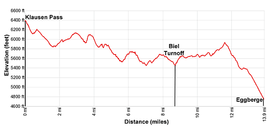
Details: Klausen Pass to Eggberge 
Distance: 9.5 - 13.9 miles (one way)
near Altdorf in The Bernese Oberland
Hike Facts
- Distance: 9.5 - 13.9 miles (one way)
- Elevation: 6,400-ft. - 4,712-ft.
- Elevation Gain: -1,688-ft.
- Difficulty: moderate-strenuous
- Trail Highlights: See Trail Intro
- Basecamp(s): Altdorf
- Region: The Bernese Oberland
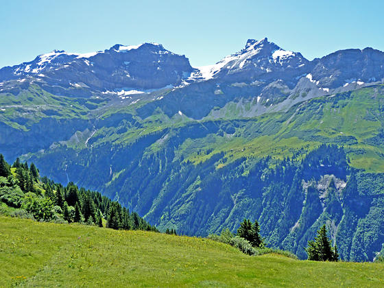
Running between Klausen Pass and Altdorf, the Schachental Hohenweg trail travels high above the north side of the Schachental Valley in the Schwyz Alps with panoramic views of the Glarus Alps to the south and the rugged cliffs of the Schachentaler Windgallen massif towering overhead
Klausen Pass to Biel
Distance from Trailhead: 9.5 miles (one way)
Ending/Highest Elevation: 5,337-ft.
Elevation Gain: -1,063-ft.
Note: There are many ascents and descents along this trail. The actual elevation gain to Eggberge is almost 2,400-ft. while the elevation loss is over 4,000-ft. If you stop at Biel, the elevation gain is about 1,800-ft. while the loss is over 2,800-ft.
The first 1.6 miles of this trail travels along or near the Klausen Pass Road. This description assumes you start at Klausen Pass. You can avoid the walk along the road by taking the bus to Untere Balm, below the west side of Klausen Pass. (See the trailhead directions below.) If you start at Untere Balm subtract 1.6 miles from the mileage in the description below.
From Klausen Pass (6,400-ft.) find the paved path on the south side of the highway, just to the west of the chapel (Kapelle Bruder). Walk south on the path. Soon you will see a signed trail branching right (west) toward Untere Balm, Spiringen and Biel. Turn right and descend through meadows on moderate grades. The trail is marked by white and red posts.
A rugged ridge anchored by the Marcher Stockli towers above north side of the pass. Ahead are distant views of the high peaks, including the Uri Rotstock, Brunnistock and Blackenstock, rising above the west side of Altdorf and the Reuss Valley.
After half a mile the trail ascends to the road and then descends on moderate grades alongside the road to a hairpin curve at Untere Balm at 1.6 miles. Along the way views open to the glacier-clad Scharhorn (10,807-ft.) towering above the emerald green meadows to the south.
At Untere Balm cross the road and then follow the Hohenweg Schachental (Trail #595) toward Biel and Eggberge. (Note: You are also following Trail #1, the Via Alpina or Alpine Pass Route. At 5.1 miles the two trails will diverge.) The broad track now ascends on easy to moderate grades through pastures and meadows beneath rugged cliffs. Across the valley to the south enjoy ever evolving views of the Scharhorn and nearby peaks in the Glarus Range.
At 2.25 miles the path curves around the end of a ridge and then ascends across a shallow valley, echoing the contours of the landscape. Along the way the path passes small farms and a few trails branching off to the right and left. At all intersections continue on the #595 Hohenweg trail.
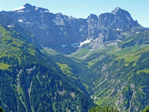
At 2.9 miles the trail begins a descent that crosses gullies draining the rugged slopes of the Schachentaler Windgallen massif towering overhead. Across the valley to the south Gross Ruchen (10,295-ft.) and Gross Windgallen (10,457-ft.) form the backdrop for the Brunnital Valley, a deep south to north valley that drains into the Schachental. To the southeast the Chammliberg (10,548-ft.) and Clariden (10,718-ft.) are now seen rising along the ridge to the east of the Scharhorn.
Watch for the Alp Stafel junction at 3.5 miles where trail #595 turns right onto a foot path that climbs steeply before descending to meet a broad track at 3.9 miles. Head down the track for 0.2 miles and then turn right on a trail signed for the #595 Hohenweg.
The undulating path now descends through meadows and clusters of trees as it cross a few minor ridges and contours around drainage channels. Reach a junction at Hegerwald at 5.1 miles where trail #1, the Via Alpina, turns lefts and descends steeply downhill. We continue straight ahead on the #595 Hohenweg.
At 5.6 miles the descent ends as the path climbs over an old rock slide and then briefly joins a broad track. Here great views open to the high peaks towering above the foot of the valley above the west side of Altdorf. The Gross Spitzen (7,873-ft.) dominates the view to the south.
At 6.1 miles a small yellow sign with the word “Wanderweg” points to a trail branching right from the track. Bear right on the Wanderweg, which descends on moderate grades, crosses a broad track at Sidenplangg and then joins a farm road at Abneter Wald at 6.5 miles. The descent continues along the road.
Reach a junction of two roads at 6.9 miles. Bear right and start ascending on a broad track that passes the alp of Rietlig. This section of the trail enjoys great views of Altdorf and the high peaks rising to the west/southwest.
At 7.5 miles the broad track curves to the right into a side valley. A short distance beyond the ascent ends and the track now descends on easy grades, reaching the junction with the trail to Biel at 8.6 miles. If you are ready to end the hike, bear left toward Biel on a trail that initially descends and then ascends to the lift station at 9.4 miles. Here a small cable car descends to Brugg on the Klausen Pass road. Otherwise, continue along the #595 trail toward Eggberge.
(At Biel you will also find accommodations, so it is possible to stop here for the night and then continue onto Eggberge and Altdorf. Accommodations are also available at the Edelweiss Skihaus at 9.1 miles.)
To Eggberge
Distance from Trailhead: 13.9 miles (one way)
Ending/Highest Elevation: 4,712-ft.
Elevation Gain: -1,688-ft.
Beyond the Biel junction the trail ascends and soon emerges from the side valley, crossing a second junction with a trail branching left toward Biel at 9.0 miles. A short distance beyond the path curves around the head of a ridge, passing the Edelweiss Skihaus and Restaurant in the small hamlet of Wiltschi at 9.1 miles.
Past the restaurant the undulating path curves to the left and enters a second side valley. Ahead are good views of the rugged ridge rimming the north side of the valley. The trail again exits the side valley, curves around the head of a ridge and enters a third side valley.
At 10.6 miles, near the head of the third side valley, the trail begins ascending on easy to moderate grades. The ascent ends at 11.5 miles as the trail emerges from the side valley, crests a ridges and arrives at the Gross Flesch (aka Fleschsee), a small tarn nestled along the west side of the ridge.
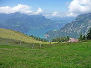
From this point the path descends on moderate grades, losing over 1,200-ft as it drops through trees and pastures to Eggberge at 13.9 miles. The village is set atop a grassy bench at the confluence of the Schachental and Reuss valleys. View stretch northwest to the Urnersee (aka Lake Lucerne), a large lake, and west/southwest to the high peaks towering above the Reuss Valley. At Eggberge a cable car descends to Fluelen, a town near the head of the Urnersee, where buses travel to Altdorf. A nearby train station offers transportation to places farther afield.
The Schachental Hohenweg continues beyond Eggberge, losing 3,320-ft as it drops to Fluelen. Allow 2 hr and 35 minutes for the hike down. I suggest avoiding the knee pounding descent and instead take the cable car.
Elevation Profile
Driving Directions
From Altdorf to Klausen Pass: From Altdorf catch the #408 bus at Telldenkmal, the main square in the center of town, to Klausen Passhole (Klausen Pass). If starting from the Altdorf train station take a bus from the train station bound for Brugg and then change at Telldenkmal for the #408 bus to the pass. Check the schedule before setting out. Given the length of this hike it is best to catch an early bus. The ride to the pass takes about 55 minutes.
Bus schedules are posted at the bus stops or are available online at the SBB website or the SBB app. When looking for buses use “Altdorf UR, Telldenkmal”, the UR in the name stands for the canton of Uri.
From Altdorf to Untere Balm: From Altdorf catch a bus at Telldenkmal, the main square in the center of town, heading toward Klausen Passhole (Klausen Pass) and get off at Untere Balm. If starting from the Altdorf train station take a bus from the train station bound for Brugg and then change at Telldenkmal for the bus to the pass. Again get off at Untere Balm. Check the schedule before setting out. Given the length of this hike it is best to catch an early bus. The ride to the Untere Balm takes about 47 minutes.
Bus schedules are posted at the bus stops and are available online at the SBB website or the SBB app. When looking for buses use “Altdorf UR, Telldenkmal”, the UR in the name stands for the canton of Uri. The stop you want is Unterschachen, Untere Balm.
From Biel Seilbahn/Brugg to Altdorf: From the valley station for the Biel Lift, walk down to the bus stop, located adjacent to a parking lot along the Klausenpass Road. Take the B3 bus bound for Seedorf or the B408 bus bound for Fluelen. Check the bus schedules posted at the bus stops and available online at the SBB website or the SBB app to make sure you are headed in the right direction. When looking for buses use “Altdorf UR, Telldenkmal”, the UR in the name stands for the canton of Uri. The ride takes about 17 minutes. See the the Biel to Brugg Seilbahn schedule for more information on the lift (in german).
From Eggberge Luftseilbahn/Flüelen to Altdorf: From the valley station of the Eggberge lift, walk a short distance to the Fluelen/Eggberge bus stop and catch the B408 toward Balm (Klausen) or B1 bus toward Goschenen or Amsteg and get off at Telldenkmal in the center of Altdorf. The ride takes about 9 minutes. Note: The B1 bus heading south lists different end points. Check the bus schedules which are posted at the bus stops and also available online at the SBB website or the SBB app to make sure you are headed in the right direction. When looking for buses use “Altdorf UR, Telldenkmal”, the UR in the name stands for the canton of Uri. See the Eggberge Luftseilbahn schedule for more information on the lift.
Trail Resources
Trail Intro / Trail Photo Gallery / Trail Map
Basecamp(s) Information:
Altdorf
Region Information:
The Bernese Oberland
Other Hiking Regions in:
Switzerland