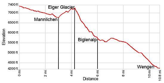
Details: Mannlichen to Wengen 
Distance: 10.8 miles (one way)
near Grindelwald in The Bernese Oberland
By: Diane Greer
Hike Facts
- Distance: 10.8 miles (one way)
- Elevation: 7,293-ft. - 4,190-ft.
- Elevation Gain: -3,103-ft.
- Difficulty: moderate
- Trail Highlights: See Trail Intro
- Basecamp(s): Grindelwald / Lauterbrunnen
- Region: The Bernese Oberland
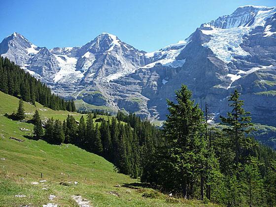
A triad of giants; the Eiger, Monch and Jungfrau, dominate the breathtaking views along this scenic hike from Mannlichen to Wengen.
Mannlichen to Kleine Scheidegg
Distance from Trailhead: 2.8 miles (one way)
Ending/Highest Elevation: 6,762-ft.
Elevation Gain: -531-ft.
The day starts by taking a gondola to Mannlichen (7,293-ft.), a small alp situated on a scenic ridge separating the Lutschental and Lauterbrunnental (Grindelwald and Lauterbrunnen Valleys). (See trailhead directions below.) Overlooks atop the ridge near the lift station enjoy great views to the west/southwest up the length of the Lauterbrunnen valley to the Jungfrau, Breithorn and Tschingelhorn along with the peaks lining the Sefinental valley. The Wetterhorn, Schreckhorn, Eiger and Monch dominate the skyline to the east.
Outside the lift station signs point south/southeast to Kleine Scheidegg (1-hr 30-min) along the Hohenweg 2100m. This is one of the themed walks in Grindelwald also known as the Panorama Trail or Panoramaweg. Other signs point north to the Mannlichen viewpoint, reached via the "Royal Walk" themed trail.
To reach Kleine Scheidegg, walk to the east side of the lift station and then turn right (south/southeast) on a broad gravel track descending on easy grades through meadows along the base of Mt. Tschuggen (8,270-ft.). In route enjoy wonderful views of the Wetterhorn, Schreckhorn and the massive north wall of the Eiger towering above the Grindelwald valley to the east.
At 1.5 miles the trail curves to the right (south) around a ridge extending from Mt. Tschuggen. A short distance beyond the trail again curves to the right (southwest), crosses under the Honegg chairlift and then descends along the south facing slopes of Mt. Tschuggen. Ahead are fine views of the rugged east wall of the Lauberhorn (8,110-ft.). To the south the Monch and Jungfrau form a beautiful backdrop for the trail descending to Kleine Scheidegg.
Cross the creek draining the slopes between Mt. Tschuggen and the Lauberhorn at 2.1 miles. Beyond the creek the trail turns to the left (southeast) before curving to the right (south) along the base of the Lauberhorn. Ignore the trail branching to the right and climbing toward to Lauberhorn at 2.5 miles. Instead, continue straight ahead toward Kleine Scheidegg.
On a clear day the views of the Eiger, Monch and Jungfrau from this segment of the trail are nothing short of spectacular. Look carefully to see the Jungfraujoch, the highest train station in Europe, housed in a gleaming silver building on the saddle between the Jungfrau and the Monch.
Soon the path reaches the Rotstockli (6,923-ft.), a scenic overlook with terrific views of the Eiger’s north wall soaring overhead. From here the trail descends on moderate grades to Kleine Scheidegg (6,762-ft.), located on a saddle between the Lauberhorn and the Eiger, at 2.8 miles.
The railway station at Kleine Scheidegg connects trains from Grindelwald and Lauterbrunnen with trains heading for the Jungfraujoch, a line that partially travels through tunnels dug through the Eiger. The Jungfraujoch (11,371-ft.), or “Top of Europe”, is an extremely popular destination with several panoramic restaurants and overlooks. As a result the area around Kleine Scheidegg, including the restaurants, souvenir shops and bathrooms, are often crowded with hordes of tourists.
Kleine Scheidegg to Eiger Glacier Viewpoint
Distance from Trailhead: 4.3 miles (one way)
Ending/Highest Elevation: 7,250-ft.
Elevation Gain: 488-ft.
From Kleine Scheidegg there are a number of routes to Wengen. The shortest and least scenic descends along the rail line to Wengen. A quick look at a map will show you a variety of possibilities.
My preferred route is a longer and very scenic, visiting the Eiger Glacier before descending to the beautiful alps of Biglenalp and Mettlenalp and then swinging north toward Wengen. Terrific views of the Eiger, Monch, Jungfrau and the high peaks towering above the Sefinental and Lauterbrunnen valleys are your constant companion along much of the trail.
When you are done exploring the Kleine Scheidegg area cross to the south side of the rail tracks and locate the trail signs near the base of the steps leading to the Hotel Bellevue des Alps, an old wood hotel. Follow the signs pointing to the Eigergletscher (Eiger Glacier), directing you to climb the stairs and then turn right, following a broad track ascending on moderate grades above the left (east) side of the train tracks for the Jungfraujoch.
Reach the Fallbodensee, a pretty little lake, at 3.5 miles. On a still day the mirror-like surface of the lake is a photographer’s dream with beautiful reflections of the Wetterhorn and Eiger. On the south side of the lake a small building houses an interesting exhibit showing the various routes climbing the Eiger’s north wall. It’s definitely worth a stop.
At the southeast end of the lake the trail turns right (south) and drops down a gravel track passing through a culvert going under the train tracks. Beyond the culvert the trail resumes its moderate climb, heading south toward the moraine of the Eigergletscher. At 4.0 miles the trail curves to the left (east) as it drops into a shallow bowl and then climbs to an overlook atop the moraine at 4.25 miles. The moraine crest features great views of the glacier tumbling down the rugged slopes between the Eiger and the Monch.
Eiger Glacier Viewpoint to Wengen
Distance from Trailhead: 10.8 miles (one way)
Ending/Highest Elevation: 4,190-ft.
Elevation Gain: -3,103-ft.
Signs atop the moraine point left (northeast) toward the Eigergletscher train station and right (southwest) to Biglenalp, Mettlenalp and Wengen. After viewing the glacier, turn right and descend the steep, narrow trail running along the crest of the moraine. Keep an eye out for a small herd of chamoix that graze along the slopes of the moraine wall.
At 4.4 miles, where continued travel along the top of the moraine is no longer safe, the trail turns right (west), drops off the moraine wall and descends steeply through pretty meadows. The Monch and the Jungfrau tower overhead. To the west views extend to the peaks rising above the Lauterbrunnen Valley.
Reach the junction at Haaregg (6,529-ft) at 4.8 miles and turn left toward Biglenalp (35-min) and Wengen (2-hr 20-min). The trail to the right heads toward Wixi and Wengernalp, a stop on the train going to Wengen and Lauterbrunnen.
Our trail now descends southwest on moderately steep grades along the top of an old moraine. Along the way the meadows give way to low-lying shrubs and small conifers. At 5.3 miles reach an intersection with a trail branching right toward Wengernalp. We turn left on the Bergwanderweg that drops down switchbacks to a trail junction at Weisse Fluh (6,020-ft.) at 5.5 miles. Here we turn left, descending south/southeast toward Biglenalp (15-min) Mettlenalp (50-min) and Wengen (2-hr). The trail to the right leads to the Wengernalp train station.
Follow the trail, covered with roots, as it drops through trees on moderate to moderately-steep grades toward the valley floor. Soon the trees give way to beautiful meadows. A short descent leads to Biglenalp at 6.0 miles, situated along a pretty stream. The meadows around Biglenalp enjoy gorgeous views of the Eiger, Monch and the Eiger Glacier. The Jungfrau looms overhead. Across the valley, waterfalls cascade down clefts in the rugged walls along the base of the Jungfrau. This is a great spot for a picnic or to take a break.
Don’t cross any of the bridges at Biglenalp, instead turn right and descend along the right (north) side of the stream. Soon the trail curves right (west/northwest) away from the stream, traveling through meadows and clusters of trees.
At 6.6 miles the path begins an easy ascent that ends at a junction with a gravel road at Mettlenalp (5,660-ft.) at 7.2 miles. Continue straight ahead on the gravel road in the direction of Stalden (15-min) and Wengen (1-hr 20-min). The road descends on easy grades through open pastures, passing a few farm buildings along the way. This section of the trail enjoys excellent views of the glaciers cascading down the slopes of the Monch and the Jungfrau. On a warm summer afternoon lucky hikers may see an icefall crashing down the rugged cliffs.
Take a detour along the narrow trail branching left at 7.6 miles, which leads to a scenic overlook with breathtaking views of the Eiger, Monch and Jungfrau. To the west the Bietenhorn and Schilthorn fill the skyline above the Lauterbrunnen Valley. To the south the Gspaltenhorn, rising above the Sefinental Valley, and the Breithorn, at the head of the Lauterbrunnen valley, dominate the view.
Beyond the overlook follow the signs pointing toward Wengen. The road soon enters the trees as it swings to the right (north/northeast) and climbs over a low hill. Here you get your first distant views of Wengen, nestle in a bowl beneath the west flanks of the ridge separating the Lutschental and Lauterbrunnental. Look carefully along the top of ridge to see the cable car station at Mannlichen.
The trail now starts a long descent on moderate grades heading northeast toward Wengen. Ignore any trails branching left toward Lauterbrunnen. Along the way, pass by Langetrejen, Hannegg and Allmend before the final descent to Wengen. Near Wengen the gravel track turns to a paved road and soon passes under the rail line. Turn left (west) at the next intersection, following the road to the Wengen Bahnhof (train station) at 10.8 miles. Here trains descend to Lauterbrunnen or go up to and over Kleine Scheidegg to Grindelwald. Alternatively you can take the cable car from Wengen back to Mannlichen and then the gondola from Mannlichen down to Grindelwald.
Elevation Profile
Driving Directions
From the Grindelwald Bahnhof (train station) to Mannlichen: From the Grindelwald train station walk a short distance to the east along the main street to the main bus stop on the south side of the road and catch the #121 bus to Terminal or #123 bus toward Itramen Egg. Get off at the Terminal stop where a new facility includes the valley stations for the Mannlichen and Eiger Express gondolas. The bus rides take about 8-12 minutes. You can also take the train from Grindelwald Bahnhof to Grindelwald Terminal. The ride takes five minutes.
Alternatively, from the train station follow the yellow signs pointing to the Terminal station for the Mannlichen and Eiger Express gondolas, which is to the northwest of the Grund Station on the Kleine Scheidegg line. The walk descends the hillsides to the south/southwest of the train station, using a combination of walkways and roads to the Terminal Station, a new facility for the Mannlichen and Eiger Express Gondolas. Allocate about 20 minutes for the 0.9 mile walk. The ride up the world’s longest passenger-carrying gondola takes about 30 minutes and is quite scenic.
From Lauterbrunnen to Mannlichen: From the train station in Lauterbrunnen, catch the cog railway heading toward Wengen/Kleine Scheidegg and get off in Wengen. (The ride to Wengen takes about 14 minutes.) In Wengen walk behind the train station to Dorfstrasse (the main street) and turn left (northwest). Soon you will see signs pointing right to a road leading to the cable car station. Along the way pass the Wengen tourism office. Purchase a one-way ticket and take the cable car to Mannlichen. The cable car climbs over 3,000-ft. and takes about 5 minutes. Keep an eye out for chamoix grazing on the grassy slopes beneath the cable car.
From Wengen to Mannlichen: In Wengen, the bottom station for the cable car is located to the north/northeast of the train station. Walk behind the train station to Dorfstrasse (the main street) and then turn left (northwest). Soon you will see signs pointing right to the cable car station. Along the way pass the Wengen tourism office. Purchase a one-way ticket and take the cable car to Mannlichen. The cable car climbs over 3,000-ft. and takes about 5 minutes. Keep an eye out for chamoix grazing on the grassy slopes beneath the cable car.
From Wengen to Lauterbrunnen/Grindelwald: From the train station in Wengen catch the cog railway heading down to Lauterbrunnen. (The ride takes about 14 minutes.) To travel to Grindelwald, at the Lauterbrunnen train station take a train heading to Interlaken and get off at Zweilutschinen where you catch a connecting train to Grindelwald.
Trail Resources
Trail Intro / Trail Photo Gallery / Trail Map
Basecamp(s) Information:
Grindelwald / Lauterbrunnen
Region Information:
The Bernese Oberland
Other Hiking Regions in:
Switzerland