Details: Lötschentaler Höhenweg 
Distance: 10.8 - 12.8 miles (one way)
near Kandersteg in The Bernese Oberland
Hike Facts
- Distance: 10.8 - 12.8 miles (one way)
- Elevation: 4,500-ft. - 6,950-ft.
- Elevation Gain: 4,050-ft.
- Difficulty: strenuous
- Trail Highlights: See Trail Intro
- Basecamp(s): Kandersteg
- Region: The Bernese Oberland
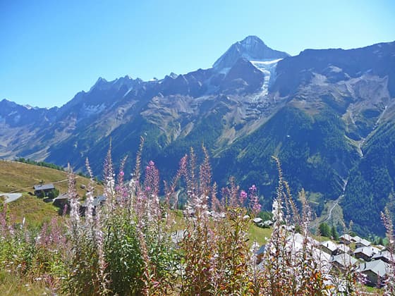
Soaring peaks, a glacier-clad cirque, pretty villages, and nonstop views are the hallmarks of this scenic hike traveling high above the north side of the Lötschental. Views stretch up the length of the panoramic valley and south to the high peaks towering above the Valais.
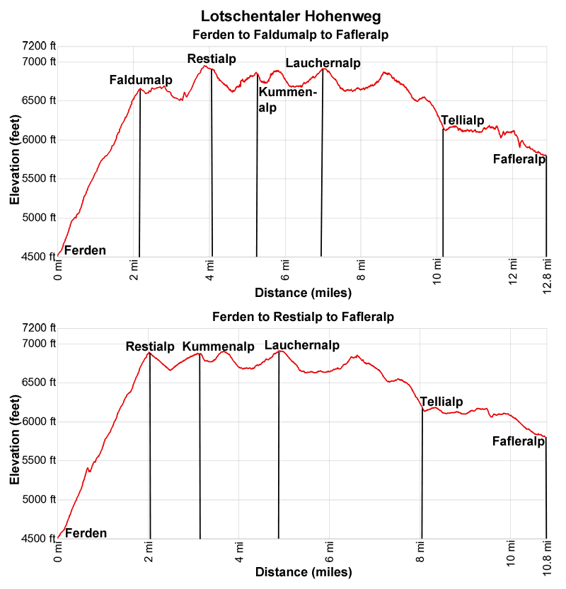
Lotschentaler Hohenweg

Note: The elevation gains and losses along the Hohenweg are greater than the difference between the highpoint on the hike and the trailhead elevation. Each starting option lists the cumulative elevation gain and loss.
For a description of the 10.8 miles hike from Ferden to Restialp to Fafleralp, skip the initial sections of this description and start reading at “Starting Option 2: From Ferden to Restialp”.
Starting Option 1: From Ferden to Faldumalp
Distance: 12.8 miles (20.6 km)
Elevation gain/loss: +4,050 / -2,754-ft (+1,234/ -840-meters)

From the bus stop in Ferden (see trailhead directions below), find the trailhead signs on the north side of the road. Here signs point northeast up a cobblestone road to Zum Lötschentaler Höhenweg (to the Lötschentaler High Route): Faldumalp (2 hr) and Restialp (2hr). Follow the road as it ascends on moderate grades past a few houses. At the first intersection turn left on a paved track toward Faldumalp and Restialp.
Head up the road. Shortly after crossing an intersection reach a post with signs pointing left (west) toward Faldumalp and Restialp. The path leaves the road and ascends through trees, crossing the road again at 0.4 miles (0.6 km). A short distance beyond, reach a trail junction. Here the trail to Restialp turns right (northwest). We turn left (west) toward Faldumalp.
The trail to Faldumalp ascends steeply through meadows and trees, crossing a stream at 0.7 miles (1.1 km). Openings offer ever-improving views of the peaks rising across the valley and the summits in the distance to the south.
At 1.5 miles (2.4 km) the path reaches the road heading to Faldumalp. Turn right, follow the road for a short distance and then bear left on the continuation of the trail, which now ascends through trees. Soon the path turns left on a switchback and we leave the trees, ascending steeply along grassy slopes above the north side of the Faldumbach (Faldum stream). A few switchbacks ease the ascent. Ahead views open to Faldumalp with its distinctive wood chapel.
At 2.1 miles (3.4 km) the path curves to the left and reaches a junction. Turn left toward Faldumalp on a track that crosses the Faldumbach on a bridge. Past the bridge the trail ascends to Faldumalp at 2.2 miles (3.5 km). The village with its pretty wood chapel is set atop an overlook with stunning views up the length of the Lötschental. The Faldumrothorn rises to the west.
Faldumalp to Restialp
After visiting the chapel and taking in the views, retrace your steps, descending to and crossing the bridge over the Faldumbach. Reach the trail junction beyond the bridge at 2.3 miles (3.7 km). Continue straight ahead (north) toward Restialp.
The narrow path travels through meadows and trees on easy to moderate grades. A few short sections of the trail are somewhat exposed but are secured with fix cables. Along the way enjoy panoramic views of the Lötschental.
On a clear day you should be able to see the Breithorn, Grosshorn, Sattelhorn and Schinhorn anchoring the cirque towering above the head of the valley. The Lang and Anun glaciers spill down the slopes of the cirque. Turn around for views of Faldumalp and the distant, ice-clad peaks of the Mischabel Range rising to the south.
At 3.1 miles (5.0 km) the path curves to the left around the slopes at the end of the Faldumgrat (Faldum Ridge) and then ascends through a tributary valley, crossing the Dornbach – the stream draining the slopes beneath Restipass. Beyond the crossing the trail climbs up the slopes above the north of the stream before descending gently to Restialp and a junction at 4.0 miles.
At the junction a trail branches left, climbing to Restipass, the saddle on the ridge at the head of the tributary valley between the Restirothorn and the Loischerspitza. We continue straight ahead on the Lötschentaler Höhenweg. Soon the path reaches a second junction with the trail coming up from Ferden at 4.1 miles (6.6 km). We now leave the village, continuing straight ahead on the Lötschentaler Höhenweg toward Kummenalp, Lauchernalp and Fafleralp, accompanied by more great views up the length of the Lötschental.
Skip to the Restialp to Lauchernalp section.
Starting Option 2: From Ferden to Restialp
Distance: 10.8 miles (17.4 km)
>
Elevation gain/loss: +3,342 / -2,040-ft. (+1,018/ -622-meters
This is a description of the alternative start for the hike from Ferden to Restialp to Fafleralp.

From the bus stop in Ferden (see trailhead directions below), find the trailhead signs on the north side of the road. Here signs point northeast up a cobblestone road to Zum Lötschentaler Höhenweg (to the Lötschentaler High Route): Faldumalp (2 hr) and Restialp (2hr). Follow the road as it ascends on moderate grades past a few houses. At the first intersection turn left on a paved track toward Faldumalp and Restialp.
Head up the road. Shortly after crossing an intersection reach a post with signs pointing left (west) toward Faldumalp and Restialp. The path leaves the road and ascends through trees, crossing the road again at 0.4 miles (0.6 km). A short distance beyond, reach a trail junction. Here the trail to Faldumalp turns left (west). We turn right on the trail to Restialp.
The path ascends steeply on switchbacks through trees and intermittent meadows. At all intersections take the trail marked for Restialp. At 0.9 miles (1.4 km) the path briefly travels along a road to a three-way junction at Barsol. Here roads branch left toward Faldumalp and right to Restialp. We continue straight ahead the trail to Restialp, which short-cuts long switchbacks on the road. As the path gains elevation openings offer distant views of the peaks in the Mischabel Range to the south and great views up the length of the Lötschental.
At 1.5 miles (2.4 km) the path again joins the road to Restialp, ascending a short distance up a switchback (follow the sign saying Wanderweg) before turning left onto the continuation of the trail. Be sure to watch for signs indicating where the trail leaves the road and continues its steep ascent up the hillside.
At 2.1 miles (3.4 km) the trail reaches Restialp and a junction with the Lötschentaler Höhenweg. Here we enjoy fine views up the length of the Lötschental. When you are ready to continue turn right on the Hohenweg toward Kummenalp, Lauchernalp and Fafleralp.
The remainder of this trail description assumes that you are doing the full Lötschentaler Höhenweg from Ferden to Faldumalp to Fafleralp. If you are cutting off the first section of the hike and instead walking from Ferden to Restialp, subtract 2.0 miles (3.2 km) from the trail distances in the description below.
Restialp to Lauchernalp
From Restialp a broad track descends on moderate to moderately steep grades accompanied by fine views of the Bietschhorn, Breitlauihorn and Breithorn towering above the south side of the valley. Turn around for views of the peaks rising in the distance to the south.
The grade abates at 4.5 miles (7.25 km) as the trail curves to the left around the slopes at the head of the Restigrat (Resti Ridge) and reaches an intersection at Trockene Stiege. Continue straight ahead on the Hohenweg that now ascends through a second tributary valley accompanied by views of the Ferdenrothorn and Balmhorn rising to the west/northwest. Lotschenpass, the saddle on the ridge beneath the Balmhorn, leads to Selden in the Gasterntal. Kummenalp sits on a shelf above the north side of the valley.

At 4.9 miles (7.9 km) the trail curves to the right and crosses a bridge over the Fardanbach, a stream draining the tributary valley, and then ascends to Kummenalp and a junction at 5.2 miles (8.4 km). Here two trails branch left. One to Ferdenpass and Leukerbad and the second to Lotschenpass, Selden and Kandersteg. We bear right on the continuation of the Lötschentaler Höhenweg toward Hockenalp and Lauchernalp.
After descending to cross a bridge over a stream, the path soon passes a trail dropping down to Kippel along the valley floor. After a brief, easy stretch the trail again ascends and then descends along the steep slopes above the north side of the valley.
At 6.1 miles (9.8 km) the grade briefly abates as the trail crosses the Golmbach, a stream draining the slopes beneath the Hockenhorn, looming overhead. A short distance beyond, the trail joins a wide track ascending to Hockenalp at 6.5 miles (10.5 km). Here a junction marks a trail branching right and dropping down to center of Lauchernalp where the Lauchernalp Bergbahn, a cable car, descends to Wiler, located along the valley floor. This is a good place to cut the hike short if the weather is taking a turn for the worse. Otherwise continue straight ahead on the Hohenweg toward the upper section of Lauchernalp.
Beyond Hockenalp the trail ascends on moderate grades to upper section of Lauchernalp and a junction at 7.0 miles (11.25 km). Nearby you will see the upper station of the Lauchernalp-Stafel lift, which only operates in the winter. Turn right and walk a short distance along the broad track to a second junction. Here a trail branches right and descends to the Lauchernalp Bergbahn (cable car) descending to Wiler. This is another opportunity to cut the hike short.
From Lauchernalp to Fafleralp

To continue the hike, stay on the Lötschentaler Höhenweg by following the signs pointing toward Weritzalp and Fafleralp. The broad track now descends through the upper part of the village to a junction at 7.3 miles (11.7 km). Here we leave the road, bearing left on a trail toward Weritzalp and Fafleralp. The grade eases as the path, now traveling through pastures, curves to the left. Along the way our trail joins with a path coming up from the Lauchernalp Bergbahn station in the lower part of the village.
At 7.5 miles (12.1 km) the trail curves to the right and crosses a bridge over the Milibach. Beyond the crossing the path follows an undulating course though pretty meadows along the north side of the Loetschental. Along the way turn around for distant views of the Weisshorn, towering above the ridges to the south. The Bietschhorn and its glaciers dominate the view across the valley while the summits of the peaks rimming the north side of the valley are seen above the trail.
At 8.0 miles (12.9 km) the trail briefly joins a road at Biel and quickly reaches a junction. Bear right on a trail, which drops below the road toward Weritzalp, Tellialp and Fafleralp. The path now ascends through meadows with scattered trees, accompanied by great views of the Bietschhorn anchoring the serrated ridge of peaks across the valley.
Reach Weritzalp and a junction at 8.5 miles (13.7 km). Here we bear right on the continuation of the Hohenweg toward Tellialp and Fafleralp. Be sure to turn around for good views of Lauchernalp and the peaks rising above the west end of the Lötschental.
The path now descends on moderate to moderately-steep grades along steep slopes clad in meadows and trees, accompanied by fine views of the summits across the valley. At 9.1 miles (14.6 km) pass a junction with a trail dropping down to Blatten on the valley floor. We continue straight ahead toward Tellialp, the Schwarzsee and Fafleralp.
Past the junction the trail enters a pretty larch forest with intermittent meadows. Soon the grade abates and the path follows an undulating course through the trees. At 9.75 miles (15.7 km) the trail curves left into Im Tellin, a tributary valley, and then descends steep switchbacks to the valley floor. Openings along the way offers glimpses of the Tellingletscher (Tellin Glacier) and the Birghorn rising to the north.
At 10.2 miles (16.4 km) the path passes the tiny hamlet of Tellialp and then drops down to cross a bridge over the Gisentella, a raging torrent carrying meltwater from the Tellingletscher. The best views of the rugged ridge and glacier are seen from the pastures on east side of the Im Tellin.

Soon the path exits the Im Tellin and follows an undulating course through larches and intermittent meadows along the Loetschental’s north slopes. Openings offer great views of the Bietschhorn, Loetschentaler Breithorn and the Lonzahoner.
At 11.1 miles (17.9 km) the trail reaches the Schwarzsee, a pretty lake set amid rocky meadows and trees. A second smaller lake is located just to the east. The lake is a popular picnic spot and a good place to cool off on a hot day.
Past the lake the trail initially ascends and then descends through trees and meadows as it curves into the Uisters Tal, a tributary valley. Ahead views open to the Tellingletscher blanketing the rugged slopes high above the valley.
At 12.0 miles (19.3 km) the path crosses the stream draining the Uisters Tal and then curves right (southeast) on a broad track that descends on moderate grades through meadows. The path soon curves to the left (east) as it exits the Uisters Tal and heads toward Fafleralp.
Reach the village of Fafleralp and a small pond at 12.4 miles (20.0 km). Continue past the village toward Fafleralp Parkplatz/Post Auto (parking lot). Soon views open to the Breithorn towering above the Inners Tal, another tributary valley. Cross a bridge over the stream draining the Inners Tal, travel through a campground and then reach a large parking area, the Fafleralp Park Platz. The bus stop and the end of the hike is located at the east end of the parking lot at 12.8 miles (20.6 km). From the bus stop stunning views stretch up the upper Loetschental to the Lang and Anun glaciers flowing down the slopes beneath the Sattelhorn and Anuchnubel.
I recommend coming back to the Loetschental another day and hiking the upper Lötschental valley from Fafleralp to Anenhutte, a 7.3 miles (11.4) loop trail leading to the Anen Hut. The entire day is filled with amazing views of the high peaks rimming the upper Loetschental Valley and the glacier-clad cirque at the head of the valley.
Elevation Profile
Driving Directions
From Wiler in the Lötschental to Ferden: From Wiler, catch the bus toward Goppenstein Bahnhof or Gampel-Steg and get off at Ferden Dorf. The bus ride takes about 8 minutes, depending on what stop is nearest your accommodations. Cross the road and find the signs pointing toward Lötschentaler Höhenweg. There are very good connections between the train and the bus in both directions. Bus schedules are available at the bus stops and online on the SBB website and the SBB app.
From Kandersteg (Bernese Oberland): From the Kandersteg Bahnhof take the train in the direction of Brig and get off at Goppenstein (about 13 minutes). Find the stairs that lead under the train tracks to the bus stop on the east side of the train station where you should board the bus bound for Fafleralp. Get off the bus at the Ferden Dorf. The bus ride takes about 5 minutes. Cross the road and find the post with trail signs pointing toward Lötschentaler Höhenweg. There are very good connections between the train and the bus in both directions. Train and bus schedule are at the train stations, bus stops and are available online on the SBB website and the SBB app.
Return from Fafleralp
From Fafleralp to Wiler: At Fafleralp take the bus going to Goppenstein Bahnhof or Gampel-Steg and get off at the stop nearest your accommodations in Wiler. The ride takes about 16 minutes. Bus schedules are available at the bus stops and online on the SBB website and the SBB app.
From Fafleralp to Kandersteg: From Fafleralp take the bus going to Goppenstein Bahnhof or Gampel-Steg and get off at the Goppenstein Bahnhof. The ride takes about 32 minutes. Check the train information screen to determine the track number for the train to Kandersteg. Typically, it leaves from Track 1. To reach Track 1 find the stairs that descend to the passage under the train tracks and to Platform 1 on the west side of the tracks. Then take the train heading to Kandersteg. The ride takes about 14 minutes. Train and Bus schedules are available at the train stations, bus stops and online on the SBB website and the SBB app.
Trail Resources
Trail Intro / Trail Photo Gallery / Trail Map
Basecamp(s) Information:
Kandersteg
Region Information:
The Bernese Oberland
Other Hiking Regions in:
Switzerland