Selden to the Kanderfirn 
Distance: 3.3 - 8.4 miles
near Kandersteg in The Bernese Oberland
By: Diane Greer
Kanderfirn (Alpetligletscher)
This scenic hike travels up the rugged Gasterntal (Gastern Valley) and then climbs steeply to viewpoints above the Kanderfirn Glacier. Two shorter versions of the hike offer beautiful views of the valley while avoiding the steep ascent to the glacier overlook.
- Distance: 3.3 - 8.4 miles (RT)
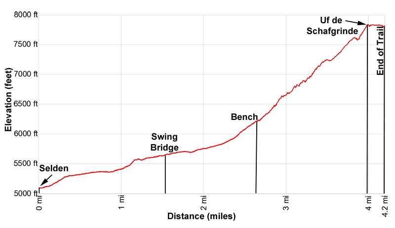
- Elevation: 5,070-ft. at Trailhead
Maximum elevation - 7,890-ft. - Elevation Gain: 2,820-ft.
- Difficulty: moderate-strenuous
- Basecamp: Kandersteg
- Region: The Bernese Oberland
Trail Description - Selden to the Kanderfirn
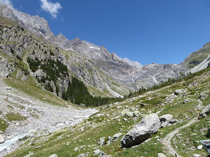
The trail up the beautiful Gasterntal (Gastern Valley) offers hikers three options; a short, easy loop hike, a moderately-strenuous mid-distance hike to a bench at the base of the cliffs beneath the upper valley and a longer, challenging hike to an overlook in the upper valley with great views of the Kanderfirn Glacier and the summits towering above this massive river of ice. Whatever your choice the trip up the valley passes through an evolving landscape where pastures and rocky meadows are slowing being buried by scree and boulders from rockslides and avalanches spilling down the rugged peaks rimming the valley.
To the north the Bluemlisalphorn, Wyssi Frau and Morgenhorn form the backdrop for the Kanderfirn, a massive river of ice flowing along the floor of the upper
Many hikers visit this interesting valley on a day trip from Kandersteg. I strongly recommend getting an early start, especially if you wish to hike to the overlook above the glacier. The trip to the trailhead starts with a ride on a private minibus that must be booked in advance. (See trailhead directions.)
Sections of the mid-distance and longer hike travel through boulder fields. Reaching the Uf de Schafgrinde, the small peak overlooking the glacier, requires a very steep climb up a rugged rock wall. The trail builders have done an amazing job building steps, reinforcing ramps up ledges and slabs and installing safety cables to facilitate the stiff ascent. As such the final section of the hike is only recommended for experienced hikers. No matter your destination you will enjoy the beautiful, unspoiled valley, devoid of ski apparatus.
Trail from Selden to the Kanderfirn
This hike starts at the Gasthaus Steinbock in Selden, the last stop on the private minibus that runs between the Kandersteg Bahnhof and the hamlet of Selden. (See trailhead directions below.) From the Gasthaus walk east up the Gasterntal (Gastern Valley) along a broad track for 0.2 miles to a junction at the bridge over the Kander River. Two trails travel to Heimritz and Uf de Schafgrinde (the overlook atop the Schafgrinde), the path straight ahead goes up the west side of the valley while the path to the right ascends the east side of the valley.
I recommend the trail up the east side of the valley which is slightly longer but has better views. To reach the east side trail turn right at the junction and cross the bridge over the Kander River. The broad gravel track ascends on easy to moderate grades through meadows, clusters of trees and avalanche chutes. Below the trail the Kander River rushes down the valley floor. Ahead the Sackhorn, Elwertatsch and Birghorn rim the east side of the valley. The rugged slopes of the Doldenhorn tower above the valley to the north while the Balmhorn fills the skyline to the southwest. The Gross Loner rises in the distance to the west beyond the foot of the valley.
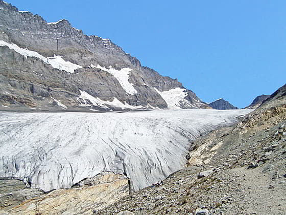
At 0.7 miles (1.1 km) reach a bridge crossing the river to the Berggasthaus Heimritz. Our trail, continuing straight ahead toward Uf de Schafgrinde, leaves the road and curves to the right as it crosses a boulder field at the base of an avalanche chute/rockslide. Views extend up the valley to the waterfalls cascading down the cliffs beneath to upper Gasterntal. The Alpetligletscher (Alpetli Glacier), the toe of the Kanderfirn, previously flowed down the cliffs but has now receded. The summits of the Frundenhorn and the Bluemlisalphorn, soaring above the upper valley, are now in view.
Soon the trail curves to the left, traveling through meadows and trees as it arcs around a meander in the river. Here the valley floor is filled with rock debris from avalanches and rockslides spilling down the valley’s slopes.
After a mile (1.6 km) the path briefly climbs and then threads its way through an avalanche chute/rockslide beneath the west facing slopes of the Sackhorn. Cairns mark parts of the route through the slide. Past the slide the path wanders through rocky meadows with lovely views of the rugged peaks rimming the valley and the waterfalls cascading down the cliffs beneath the upper valley. Turn around for fine views of the Balmhorn.
Soon the trail crosses the toe of a second rockslide and then reaches a junction at 1.6 miles (2.6 km). The trail to the left crosses the Kander River on a swing bridge and connects with the trail on the west side of the valley that leads back to Heimritz and Selden. Hikers looking for a short, easy walk can cross the bridge and then take this trail back to Selden for a 3.25-mile (5.2 km) loop. Before returning to Selden spend some time in the pretty meadows on the west side of the bridge where a bench provides the perfect spot to relax and enjoy the views of the Gasterntal.
To the Scenic Bench
To continue the hike, stay on the east side of the valley toward Uf de Schafgrinde. (The Schafgrinde is small peak with an overlook above the Kanderfirn.) The trail crosses another boulder field and then rocky meadows scattered with junipers, dwarf pines and shrubs.
At 1.75 miles (2.8 km) the trail passes an old junction with a path, now closed, that climbed the rocky slopes high above the valley floor to a moraine. The path then ascended atop the moraine toward the cliffs. This path is no longer safe for travel. Avalanches/rockfalls spilling down the slopes of the Birghorn have carved a deep ditch across the moraine and littered the area with large boulders.
In 2019 the trail was rerouted to circumvent this obstacle. The new path ascends along the east side of the valley floor, traveling through an evolving landscape where pastures and rocky meadows are slowing being buried by scree and boulders. One can only marvel at the perseverance of the trail builders who continue to adapt the trail to ever changing conditions.
As you ascend the new trail enjoy fine views of the Doldenhorn and the Frundenhorn towering above the west side of the valley along with the waterfalls spilling down the cliffs beneath the upper valley. Turn around for great views of the Balmhorn.
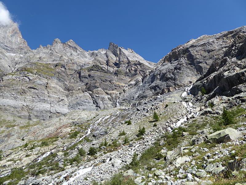
As the trail approaches the cliffs the going become more cumbersome. Red and white stripped poles now mark the route through boulder fields and across streams channeling meltwater from the high peaks above the trail.
At 2.3 miles (3.7 km) the path curves to the northeast as it ascends on steeper grades beside a channel of the Kander River. The trail soon leaves the boulder field and zig-zags up meadows scattered with dwarf conifers.
The meadows end at 2.5 miles (4.0 km) where the trail hits another boulder field. Watch for red and white striped poles and markers on the rocks to stay on track as the route ascends through the boulders. Take a break occasionally to enjoy the fine views of the high peaks rimming the valley and the waterfalls tumbling down the rugged cliffs.
The boulder field finally ends and the path now continues up rocky meadows to a bench set beneath a massive boulder at 2.7 miles (4.3 km). This is a great place to enjoy a snack and take in the views. Beyond the bench the trail becomes steeper and more challenging as it climbs up a rugged rockface to the upper valley. As you look up it seems difficult to believe that a trail scales the rock wall.
The bench is another good turnaround point for parties that do not want to climb any further or if the weather is taking a turn for the worse. Heading back from the bench results in a satisfying 5.4 miles (8.7 km) round trip hike.
To the Kanderfirn Glacier
Beyond the bench the trail switchbacks up the rockface. Man-made stone and wood supported steps, cables and reinforcements made of stone and logs facilitate the ascent through rocky meadows, over slab and up rock ledges. The terrain demands that you pay more attention to your feet than the views. Take a few breaks along the way to appreciate the vistas that extend to the peaks towering above the west side of the valley, the waterfalls spilling down the headwall and the panoramic views that stretches down the valley to the Balmhorn.
At 3.3 miles (5.3 km) the new trail intersects the old trail that previously climbed the moraine. Turn left and continue the steep ascent on switchbacks through rocky meadows. Along the way the trail climbs through a few sections of scree.
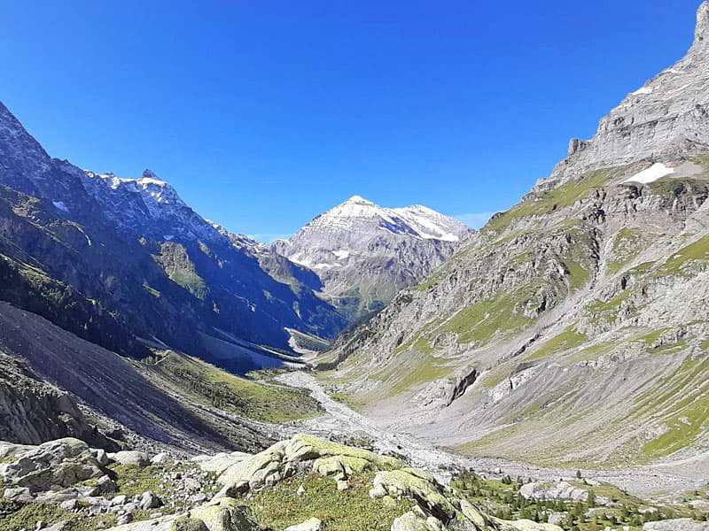
The grade abates at the trail crests the top of the wall at 3.9 miles (6.3 km). Take a quick side trip by following a spur trail up to the grassy overlook at Uf de Schafgrinde where a wood cross is supported by a large rock cairn. Here views extend down the Gasterntal to the Balmhorn towering above the valley floor. To the west/northwest a jagged ridge, punctuated by the Frundenhorn and Doldenhorn, dominates the views while the Hockenhorn and Sackhorn rim the east side of the valley. To the north the Bluemlisalphorn, Wyssi Frau and Morgenhorn form the backdrop for the Kanderfirn, a massive river of ice flowing along the floor of the upper Gasterntal. The Tschingelspitz and Mutthorn rise above the Kanderfirn at the head of the valley.
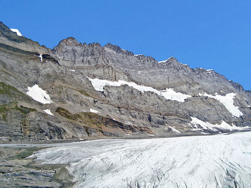
From the overlook descend back to the main trail and then follow the boot beaten path that climbs over a moraine and then descends along the flanks of the moraine to the upper valley floor at 4.2 miles (6.75 km). Here we enjoy up-close views of the toe of the snout of the Kanderfirn, which is also called the Alpetligletscher.
When you are done taking in the views, retrace your steps to the swing bridge. Here I recommend crossing the bridge and spending some time in the pretty park-like setting on the west side of the bridge. Here a bench offers lovely views up the valley. After your break return to Seldon on the trail along the west side of the valley.
Elevation Profile
Driving Directions
From Kandersteg: From the Kandersteg Bahnhof, take the bus to Selden and get off at the last stop at the Gasthaus Steinbock. This is a private bus that requires reservations (41 33 671 1172). The trip takes about 20 minutes. Make sure you also make reservations for the return journey. Bus schedules are available on the SBB website and the SBB app.
Trail Resources
- Trail Photo Gallery
- Trail Maps
- Basecamp(s) Information: Kandersteg
- Region Information: The Bernese Oberland
- Other Hiking Regions in: Switzerland