Alp Laret and Piz Clunas 
Distance: 7.3 - 9.2 miles (loop)
near Scuol in Eastern Switzerland
By: Diane Greer
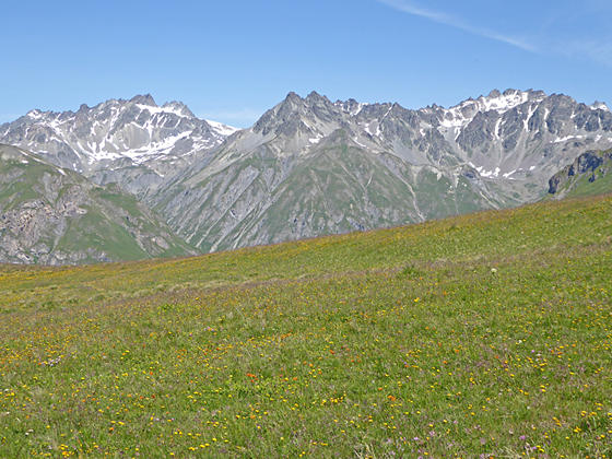
Summits towering above the Tasna and Mala Valleys
This loop hike ascends thorough lovely meadows to the overlook at Mout da l’Hom and then the summit of Piz Clunas with panoramic views of the high peaks towering above the Lower Engadine Valley and beyond.
See Trail Detail/Full Description
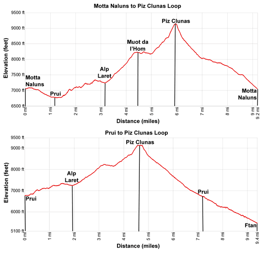
- Distance: 3.1 miles (one way) to Alp Laret
5.9 miles (one way) to Piz Clunas
9.2 miles (loop) to Motta Naluns - Elevation: 7,008-ft. at Trailhead
7,238-ft. at Alp Laret
9,160-ft. at Piz Clunas
7,008-ft. at Motta Naluns - Elevation Gain: 570-ft. to Alp Laret
1,922-ft. to Piz Clunas
-2,152-ft. to Motta Naluns - Difficulty: moderate-strenuous
- More Hikes in:
Scuol / Eastern Switzerland
Why Hike Alp Laret and Piz Clunas
This hike, starting in either Ftan or Scuol, uses ski lifts to reach the slopes high above the north side of the Lower Engadine Valley and then travels along scenic paths to pretty Alp Laret. Here the trail ascends to Muot da l'Hom, a panoramic overlook with wonderful views of the high peaks towering above the River Inn (En in Romansh) and the tributary valleys to the south and west. From the viewpoint the trail climbs Piz Clunas with superb, 360-degree views of the Lower Engadine Valley and beyond.
A steep descent down the south facing slopes of Piz Clunas leads to trail dropping steeply down to Prui and Ftan or a more gentle descent through meadows and ski slopes to the top of the Motta Naluns lift that descends to Scuol. The hike can be extended by eliminating the lifts at either the start or end of the hike.
Note: The trails along this hike, with the exception of the paths ascending and descending Piz Clunas, are open to mountain bikes. Much of this hike travels above the timberline and is not recommended during bad weather or if thunderstorms are threatening.
Elevation Profile
| Support our Site |
Trail Resources
Trail Detail/Full Description / Trail Photo Gallery / Trail Map
Basecamp(s) Information:
Scuol
Region Information:
Eastern Switzerland
Other Hiking Regions in:
Switzerland