Trail through the gorge
This trail, popular with hikers and mountain bikers, ascends through forest and then the meadows of Alp Dadaint before traveling through the dramatic Uina Gorge, a narrow chasm between two sheer rock walls.
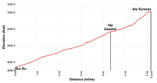
- Distance: 12.4 miles (RT)
- Elevation: 3,688-ft. at Trailhead
Maximum elevation - 7,058-ft. - Elevation Gain: 3,370-ft.
- Difficulty: moderate-strenuous
- Basecamp: Scuol
- Region: Eastern Switzerland
Trail Description - Val d'Uina
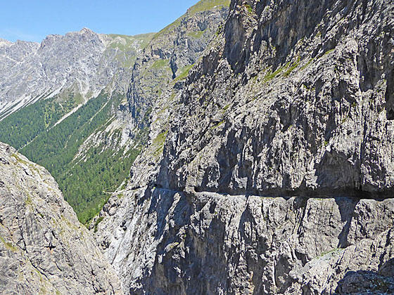
The spectacular Uina Gorge, composed of two near vertical rock walls, guards the head of the Uina Valley. When looking toward the gorge it seems impossible that a route could pass through this chasm. But a trail, carved and tunneled through the sheer rock walls, does indeed travel through this amazing gorge accompanied by dramatic views of the gorge and the river tumbling down the ravine beneath the path.
To reach the gorge requires a long hike up a forested track, with limited views, along the floor the Uina Valley. After 4.3 miles the trail breaks from the trees and we get our first views of the narrow cleft at the head of the valley.
The trail through the gorge, while exposed in sections, is secured with railings and fixed cables. People with a fear of heights or uncomfortable on exposed trail will want to avoid the hike.
This trail is very popular with hikers and mountain bikers. Hikers should expect to see bikers pushing and/or carrying their bikes through the gorge. Everyone needs to be cautious and considerate to ensure safe passage along this section of the trail. If you don’t like sharing a path with mountain bikes then find another trail.
Hiking Val d' Uina
Take the bus from Scuol to Sur En, a small hamlet located on the south side of the River Inn (En in Romansh) in the Lower Engadine Valley. (See trailhead directions below.) At the bus stop signs point southeast up the road toward Uina Dadaint and Chna Lischana (Lischana Hut).
Walk along the dirt road as it passes through the village and then ascends on moderate grades through forest along the east side of the river. Cross a bridge to the west side of the river at 0.4 miles. As you progress up the narrow valley the road will cross the river several times. All crossings are bridged.
At 2.0 miles the valley widens as the trail crosses a bridge back to the west side of the valley to avoid the remains of a landslide. Here the river has cut a channel through the rock debris deposited along the valley floor. Ahead we get our first glimpse of Piz Rims towering above the west side of the valley. Views of the peak will continue to improve as you ascend the valley.
At 2.5 miles ignore the road branching right to Uina Dadora. A short distance beyond we pass through meadows with views of the summits rising above the Curtinatsch Valley to the south and then cross a bridge to the east side of the river. A short segment of the trail along the east side of the river offers more views of the peaks rising to the west before we plunge back into the trees.
After climbing a few switchbacks the trees give way to the meadows at Alp Uina Dadaint at 4.3 miles. Here views open to Piz Mezdi and Piz da Gliasen rising along the east side of the valley. The path now ascends through the meadows, passing the alp buildings where you can purchase cheese, yogurt and other refreshments.
Past the alp the trail briefly travels through trees before again emerging on meadows with fine views toward the head of the valley. Look closely and you will see where the trail is carved into the sheer rock face.
At 5.0 miles the grade steepens as the trail ascends a rugged hillside through scattered trees. Along the way, cross a makeshift bridge over a stream tumbling down a rocky side canyon. The crossing enjoys great views down the Uina Valley to the peaks rising above the north side of the Lower Engadine Valley.
Beyond the crossing the trail climbs steeply to the entrance of the dramatic Uina Gorge, a narrow chasm between two sheer rock walls, at 5.7 miles. The trail now ascends along a path carved into the gorge’s eastern wall, high above the river tumbling down a narrow ravine. At times the trail passes through short tunnels. Handrails and fixed cables safeguard exposed sections of the trail.
Care should be used along this section of the trail. Look ahead and watch for bike riders who must carry or push their bikes through the gorge. Thankfully there are many places along the trail where it is easy to step out of the way.
The trail emerges from the Uina Gorge at 6.0 miles and soon passes a junction with trail branching right toward Rims, the Lischana Hut and the route to Fora da l’Aua at 6.2 miles. We continue toward the Sesvenna Hut on a path ascending on easy grades through the pretty meadows of Alp Sursass beneath Piz Cristanas and Piz d’Immez. The meadows are a great place to take a break and enjoy a picnic lunch before retracing your steps back through the amazing gorge to the trailhead at Sur En.
Elevation Profile
Driving Directions
From the Scuol to Sent, Sur En: From the Scuol Train station, board the #923 bus heading toward Sent, Sur En. The bus travels east along the north side of the River Inn (En in Romansh) before crossing to the south side of the river. The first stop on the south side of the river is the Sur En campground. Do not get off here. Instead, continue to the last stop in the small hamlet of Sur En. The ride takes 24 minutes.
On the way to Sur En, the bus travels through the Scuol. Consult the SBB Website/SBB app to find the bus stop nearest your accommodation.
Trail Resources
- Trail Photo Gallery
- Trail Maps
- Basecamp(s) Information: Scuol
- Region Information: Eastern Switzerland
- Other Hiking Regions in: Switzerland