Hike Facts
- Distance: 6.8 - 10.4 miles (one way)
- Elevation: 5,428-ft. - 7,664-ft.
- Elevation Gain: 2,236-ft.
- Difficulty: moderate-strenuous
- Trail Highlights: See Trail Intro
- Basecamp(s): Scuol
- Region: Eastern Switzerland
Panoramic views of rugged peaks, two beautiful valleys and a chance to see wildlife are the scenic rewards of this great hike, one of the best in the Swiss National Park, visiting Val Minger and Val Plavna.
From the Trailhead to Sur il Foss
Distance from Trailhead: 6.8 miles (round trip)
Ending/Highest Elevation: 7,664-ft.
Elevation Gain: 2,236-ft.
From the train station at Scuol, take the bus headed for S-charl and get off at the Val Minger (Mingerbrucke) stop. (See trailhead directions below.) The bus stop is located near the parking lot for a small concrete dam and water intake on the Clemgia River.
Cross the dam to the west side of the river and then follow the trail as it climbs southwest on gentle to moderate grades through a forest of larch and pine trees. At 0.3 miles the trail passes through a small meadow containing the ruins of an old stable. Here we get our first tantalizing glimpse of the scenery to come before plunging back into the woods.
Our trail soon leads to the stream draining Val Minger, which will be our constant companion along the initial segment of the hike. As the trees thin the trail passes the confluence of the Val Foraz, a side valley branching to the south at 0.8 miles. Interesting rock formations, caused by erosion of the canyon's glacial gravel walls, are found near the confluence. One of the formations looks like the head of a raven and another like the head of a witch.
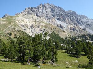
Soon views open the rugged peaks and craggy slopes flanking the Minger valley. Turn around for distant views of the peaks of the Sesvenna Lischana range, including Piz Madlain and the Piz San Jon massif, rising above the east side of the S-charl valley.
The trail now ascends at a steady pace, crossing the rocky stream four times over the next 1.25 miles. The trail and steam crossings are marked by red and white stakes. Typically the stream contains little or no water so the crossings should not present any problems.
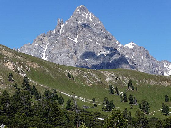
As the trees thin views open to Piz Foraz rising along the south side of the valley. The triangular top of Piz Plavna Dadaint is seen above the trees to the west. As you climb, keep an eye out for red deer and chamoix on the slopes of Piz Minger and Piz dals Cotschen, looming above the trail to the north.
At 2.2 miles the trees give way to the beautiful open meadows of Alp Minger. Reach the official park rest stop (7,115-ft.), with stunning 360-degree views, at 2.5 miles. Piz Minger towers above the valley to the north while Piz Foraz and its craggy ridges dominate the view to the south. To the west, the pyramid-shaped Piz Plavna Dadaint rises beyond Sur il Foss, the saddle on the ridge between Piz Minger and Piz Foraz at the head of the valley. To the east, the peaks soaring above the east side of the S-charl valley fill the skyline. This is another good spot to look for red deer and chamoix.
The rest area, equipped with benches and tables, is delineated by yellow posts. This is the only place in the valley where hikers are allowed to eat. My recommendation is not to eat lunch here. Instead enjoy the views and then continue to the saddle, which is outside the National Park. At the pass you can sit anywhere you like.
When you are ready to continue follow the path as it heads west, ascending on easy grades through low-lying shrubs. Soon the trail curves to the northwest, climbing through pretty meadows with great views of the peaks surrounding the valley. At 3.0 miles the grade steepens and the path curves to the west and ascends a grassy gully along the left (south) side of a stream.
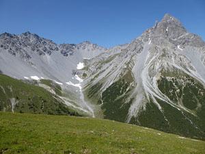
Reach Sur il Foss (7,602-ft.) at 3.4 miles. The pass, which is outside the park, is situated on a broad, grassy saddle overlooking Val Plavna to the west and Val Minger to the east. The Piz Plavna Dadaint massif dominates the view across the Plavna Valley. Piz Minger towers above the pass to the north while a rugged cirque rims the head of Val Plavna to the south. The Sesvenna Lischana range fills the skyline to the east.
At this point you have three choices. You can either turn around and retrace your steps to the trailhead for a 6.8 mile round trip hike, walk to Tarasp via the Val Plavna (3-hr) or climb to the pass at Fuorcla Val dal Botsch (1-hr 45-min) and then descend to Il Fuorn (3-hrs). I recommend walking to Tarasp via the Val Plavna. The Fuorcla Val da Botsch extension is quite strenuous and very steep. (See below for more information on this option.)
From Sur il Foss to Tarasp (Complete the Hike)
Distance from Trailhead: 10.4 miles (one way)
Ending/Highest Elevation: 4,616-ft.
Elevation Gain: -3,408-ft.
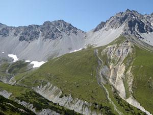
To walk to the village of Tarasp from Sur il Foss, turn left (south) toward Val Plavna and Fuorcla Val dal Botsch. The wide track travels along the top of the ridge and then traverses beneath a minor summit accompanied by fine views of Piz Plavna Dadaint massif and the glacial cirque ringing the head of Val Plavna.
Reach a junction at 3.8 miles and turn right on the trail descending toward Alp Plavna and Tarasp-Fontana. The trail straight ahead leads to Fuorcla Val dal Botsch and Il Fuorn. If you look carefully, you can see the trail to the right of the head of the valley climbing very steeply up scree-covered slopes to Fuorcla Val dal Botsch, a saddle in the ridge between Piz Murters and Piz dal Botsch.
Our trail drops down steep switchbacks and then turns north/northwest, descending through rocky meadows and then trees on steep to moderately steep grades to Alp Plavna (6,811-ft.) at 4.8 miles. Piz Plavna Dadaint towers above the idyllic little alp to the west.
At the alp the trail joins a jeep road that descends through pretty pastures sprinkled with wildflowers toward Tarasp. The walk enjoys great views of the craggy peaks lining both sides of the valley. Ahead the peaks forming the northern wall of the Lower Engadine Valley fill the skyline.
Soon the trail curves to the northwest, descending on moderate grades along the right (east) side of the Aua da Plavna, the river draining the Plavna Valley. Beyond the alp the meadows give way to trees.
At 5.2 miles the grade eases as the trail descends along a seldom used road through a massive flood plain covered in small white rocks. It appears that at times during the spring melt the stream bed widens to engulf the entire valley floor. Avalanche chutes scar the flanks of the rugged peaks lining both sides of the valley, creating wide talus aprons at the base of the peaks. It is amazing to think about the forces of water and ice that have created this landscape.
At 5.6 miles the road crosses a bridge to the west side of the river and then continues descending on easy grades along the rocky valley floor. At 6.6 miles the flood plain ends and the grade steepens as the trail drops through forest and meadows. From the meadows enjoy nice views of the peaks rising to the north of Ftan and Scuol.
At 7.3 miles the road crosses a stream and reaches a trail junction. The road branching left leads to Alp Laisch, Plaz and Ardez. We bear right on a trail dropping steeply down meadows toward Resgia Plavna and Tarasp-Fontana. Soon the valley narrows and the trail descends steep to moderately-steep grades through meadows and trees along the left (west) side of the rushing river. At 7.9 miles the trail turns into a dirt road.
Reach Resgia Plavna (5,135-ft.) and a junction at 8.7 mile. Continue straight ahead on the dirt road toward Tarasp (40-min), passing a small building with a picnic table and wood carvings of elves. Soon the road crosses a bridge to the east side of the river.
Beyond the bridge the grade abates as the trail descends through trees. Opening in the forest offer views of Ftan, nestled in meadows on a bench along the north side of the Lower Engadine Valley. Pass three more junctions, at each continue on the broad track headed toward Tarasp-Fontana.
At 9.6 miles the descent steepens as the trail curves northeast and drops down to Tarasp. As you reach the town the track turns to pavement and leads to the center of the village where the Schloss (Castle) Tarasp is perched on a high promontory above the town. The bus stop in Tarasp (4,616-ft.) is located near a peach colored building, the former Hotel Tarasp, at 10.4 miles. Before getting on the bus back to Scuol enjoy the views of Piz Lischana, which forms the perfect backdrop for the town’s picturesque little lake.
Fuorcla Val da Botsch to Il Fuorn
Distance from Trailhead: 9.0 miles (one way)
Ending/Highest Elevation: 8,782-ft.
Elevation Gain: 3,430-ft.
Note: The hike over the Fuorcla Val da Botsch is quite strenuous and includes steep ascents and descents.
To continue the hike over Fuorcla Val da Botsch to Il Fuorn from Sur il Foss, turn left (south) toward Val Plavna and Fuorcla Val dal Botsch. The wide track travels along the top of the ridge and then traverses beneath a minor peak accompanied by fine views of Piz Plavna Dadaint massif and the glacial cirque ringing the head of Val Plavna. Distant views extend north to the peaks rising above the Lower Engadine Valley.
Reach a junction at 3.8 miles. The trail to the right drops steeply to Alp Plavna and Tarasp-Fontana. We continue straight ahead (southeast) toward Fuorcla Val dal Botsch and Il Fuorn. If you look carefully, you can see the trail, located to the right of the head of the valley, climbing steeply up scree-covered slopes to Fuorcla Val dal Botsch, a saddle in the ridge between Piz Murters and Piz dal Botsch.
The trail now descends gently toward the head of Val Plavna, crossing a stream at 4.6 miles. Beyond the stream the trail turns right (southwest), ascending through rocky meadows and then climbing very steep scree covered slopes to the pass at 5.5 miles. The stiff ascent gains over 1,200-ft. in less than a mile.
Fuorcla Val dal Botsch (8,782-ft.) enjoys magnificent views of the sea of peaks to the west, including the distant Bernina Alps. Nearer at hand are great views of the cirque at the head of the Val Plavna and the Piz Plavna Dadaint massif. Piz Minger and the Sesvenna Lischana range dominate the view to the northeast while the peaks towering above the Lower Engadine Valley fill the skyline to the north.
From Fuorcla Val da Botsch, a knee crunching trail descends on steep grades to Il Fuorn (5,886-ft.), losing over 2,800-ft. in 3.5 miles. The last 0.7 miles of the hike travels along the road to the bus stop. Total hiking distance is 9.0 miles.
To return to Scuol, catch the bus to Zernez and then take the train from Zernez to Scuol. The trip back to Scuol takes 1 hour and 24 minutes.
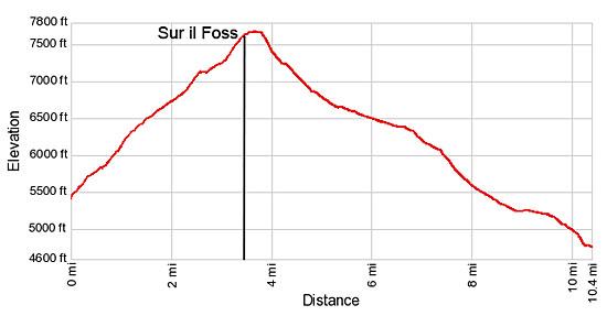
Elevation Profile
Driving Directions
From Scuol to the Val Minger Trailhead: From the train station in Scuol, take the #913 bus headed toward S-charl and get off at the Val Minger (Mingerbrucke) stop. The bus makes several stops in Scuol between the train station and Val Minger. Visit the SBB Website/SBB app to find the stop nearest your accommodations. The ride takes about 26 minutes.
If you are staying in another part of the valley, take the train or the postbus to Scuol and then catch the postbus to Val Minger. Note: This is a very popular route. Get an early start and, if possible, purchase your tickets the night before the hike.
From Tarasp to Scuol: From the Fontana bus stop in Tarasp (near a peach colored building, the former Hotel Tarasp, and across from the small lake), take the #923 bus toward Sent, Sur En and get off at the Scuol train station. The ride takes 11 minutes.
The bus makes several stops in Scuol. Consult the SBB Website/SBB app to find the stop nearest your accommodations.
Trail Resources
Trail Intro / Trail Photo Gallery / Trail Map
Basecamp(s) Information:
Scuol
Region Information:
Eastern Switzerland
Other Hiking Regions in:
Switzerland