Details: Morteratsch Glacier and Boval Hut 
Distance: 6.7 - 8.0 miles (round trip)
near St Moritz in Eastern Switzerland
Hike Facts
- Distance: 6.7 - 8.0 miles (round trip)
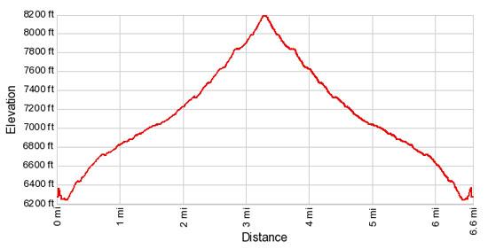
- Elevation: 6,220-ft. - 8,225-ft.
- Elevation Gain: 2,005-ft.
- Difficulty: moderate-strenuous
- Trail Highlights: See Trail Intro
- Basecamp(s): St Moritz
- Region: Eastern Switzerland
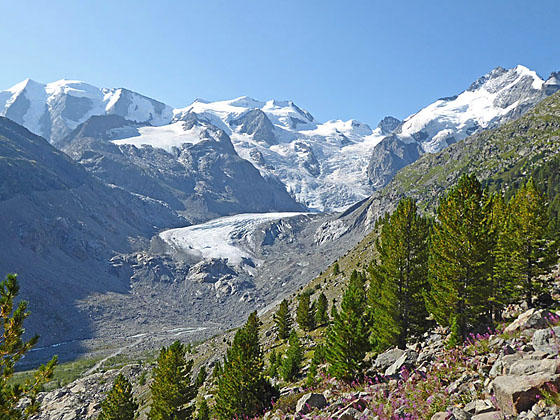
The hike to the Boval Hut enjoys breathtaking views of the dramatic glacial cirque at the head of the Morteratsch Valley, dominated by the Piz Palu and Bernina massifs along with the Morteratsch and Pers glaciers.
Boval Hut
Take the train to Morteratsch (6,220-ft.), located in the Bernina Valley. (See trailhead directions below). Walk east from the station past the Hotel Morteratsch. Turn right on the first road that crosses the train tracks. Across the track you will find hiking signs. Walk south on the broad trail toward the Vadret de Morteratsch (Morteratsch Glacier) (50-min) and Chamanna de Boval (Boval Hut) (2-hr). In less than 0.1 miles reach a junction. Turn right on the trail toward the Boval Hut. The broad trail straight ahead leads to the foot of the glacier.
Soon the trail starts ascending on moderately-steep grades up the west side of the valley through a forest of larch and pine trees. Switchbacks facilitate the climb. Openings in the trees offer tantalizing views of the high peaks and glaciers at the head of the valley.
At 0.6 miles pass a trail, branching right, to Pontresina (Puntraschigna is the Romansh spelling). A short distance beyond a second trail branches right to the Chunetta viewpoint (6,834-ft.). The short 5 minute detour to the viewpoint rewards hikers with great views of the glacier-clad peaks at the head of the valley. To be honest, these are the same views you will see soon along the main trail. Still it is a nice diversion and a good destination for parties short on time or who can’t make it all the way to the Boval Hut.
Past the viewpoint ignore the trail branching left (southeast) at 0.8 miles and dropping steeply down to the Morteratsch Glacier trail on the valley floor trail. We continue straight ahead toward the Boval Hut.
Beyond the junction the trees thin and terrific views open to the incredible glacial cirque at the head of the valley. Cross a wood bridge over a stream at 1.3 miles. Past the bridge the trail climbs to the crest of the lateral moraine along the west side of the Morteratsch glacier. The trail now travels either atop the moraine or in the trough below the moraine. Large sections of the moraine are eroded and unstable. The trail builders are in a constant battle to strike a balance between offering hikers great views of the valley while keeping parties off potentially dangerous parts of the moraine wall.
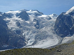
Views continue to improve as you head up valley. A wall of mountains, including Piz Palu, the Bellavista ridge, Crast' Aguzza, Piz Bernina and Piz Morteratsch, form the valley’s spectacular head wall. The Morteratsch glacier spills down from the slopes between the Bellavista ridge and Piz Bernina to the valley floor where it is joined by the Pers glacier, tumbling down the flanks of the Piz Palu massif.
At 2.1 miles views open to beautiful waterfalls, fed by glacial meltwater, cascading down the steep slopes above the trail. Munt Pers (Pers Mountain) rises above the east side of the valley. The rapidly receding Morteratsch glacier is now seen flowing along the valley floor. Across the valley the Pers glacier barely reaches the valley floor.
The grade steepens as the trail continues up the valley. Ahead a knoll protruding into the valley partially blocks the view up the valley. At 2.7 miles the moraine wall has collapsed and the trail is forced to climb switchbacks up the flanks of the rugged hillside. Fix chains safeguard steep, partially exposed sections of the trail. The grade eases at the top of the switchbacks and the path now ascends along the valley's steep western slopes high above the glacier flowing down the valley floor.
At 3.1 miles the trail rounds the knoll and views reopen to the valley's glacier-clad head wall. Piz Trovat, Piz d’Arlas and Piz Cambrena now join the scene, rising to the northeast of the Piz Palu massif. Soon the trail curves left (southwest/west) as it climbs switchbacks up rocky meadows to the Boval Hut (8,186-ft.) at 3.3 miles. The hut, sitting in rugged meadows atop a bench, offers refreshments and accommodations. Breathtaking views from the hut encompass the Bernina massif and the Morteratsch Glacier.
A use trail climbs the rocky hillside above the hut to great viewpoints with panoramic vistas of the valley’s head wall. Here you have a front row seat to the amazing spectacle of rock and ice. Piz Morteratsch, Piz Bernina, the Bellavista ridge, Piz Palu and Piz Cambrena dominate the dramatic glacial cirque at the head of the valley. The Morteratsch and Pers glaciers flow in motionless waves down the flanks of the peaks. Piz Boval towers above the hut to the west while to the east Piz Trovat, Piz d’Arlas and Piz Cambrena form an arc around a massive bowl cradling the Pers glacier.
When you are done taking in the views retrace your steps to the Morteratsch train station. Ambitious hikers can drop down to the Morteratsch Glacier trail on the valley floor (passed on the way to Boval Hut), losing about 300-ft. in 0.3 miles, and then walk up the valley for one mile to the foot of the glacier. The return trip to the Morteratsch train station from the glacier is 1.8 miles. Total hiking distance to visit the hut and the foot of the glacier is 8.0 miles.
Elevation Profile
Driving Directions
From St. Moritz to Morteratsch: Take the train from the St. Moritz Bahnhof to Morteratsch. Depending on the time of day the ride will take 24 to 28 minutes. Check the SBB website/SBB app for the current train schedule.
Trail Resources
Trail Intro / Trail Photo Gallery / Trail Map
Basecamp(s) Information:
St Moritz
Region Information:
Eastern Switzerland
Other Hiking Regions in:
Switzerland