Details: Muottas Muragl to Alp Languard 
Distance: 4.0 - 6.0 miles (one way)
near St Moritz in Eastern Switzerland
By: Diane Greer
Hike Facts
- Distance: 4.0 - 6.0 miles (one way)
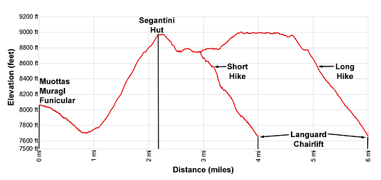
- Elevation: 8,050-ft. - 9,020-ft.
- Elevation Gain: 920-ft. - 1,556-ft.
- Difficulty: moderate-strenuous
- Trail Highlights: See Trail Intro
- Basecamp(s): St Moritz
- Region: Eastern Switzerland
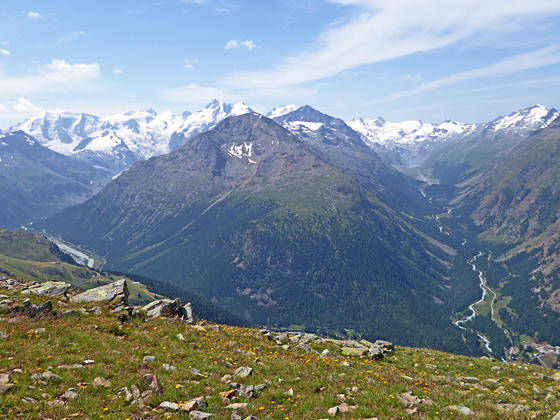
A short hike that is long on panoramic views of the high peak towering above the Roseg, Morteratsch and Upper Engadine valleys. Extend the hike with a high traverse beneath the ridge anchored by Piz Muragl and Piz Languard for great views of the Bernina massif.
Muottas Muragl to Alp Languard (short)
Distance from Trailhead: 4.0 miles (one way)
Ending/Highest Elevation: 8,970-ft.
Elevation Gain: 1,270-ft.
Take the Muottas Muragl Funicular from the Punt Muragl Talstation (bottom station) to Muottas Muragl (8,051-ft.). (See trailhead directions below). Overlooks near the exit of the funicular station offer stunning views of the Albula Alps, dominated by Piz Julier and Piz Ot, towering above the northwest side of the Upper Engadine Valley. St. Moritz, Celerina and Samedan lie nestled along the valley floor.
To the south views extend up Val Roseg to the high peaks of the Bernina Alps, including Piz Bernina, Piz Scerscen, Piz Roseg and Piz Gluschaint, to name a few. To the east/southeast, Piz Vadret and Piz Muragl fill the skyline above the Val Muragl (Muragl Valley).
After enjoying the views, find the trail signpost behind the funicular station and head southeast toward Chana Segantini (Segantini Hut). The trail descends on moderate grades through pastures, passing Alp Muottas along the way. At 0.9 miles the grade abates as the path reaches the floor of Val Muragl and passes a small building. Ignore the trail to the right that drops to Punt Muragl and Samedan.
Just before reaching a stream, pass a trail branching left at 1.1 miles toward Lej Muragl (Lake Muragl) and Fcla. Muragl (Muragl Pass). Continue straight ahead, crossing the wood bridge over the stream draining Val Muragl.
On the other side of the bridge pass a trail branching right (west) and descending to Unterer Schafberg, Alp Languard and Puntraschinga (a Romansh derivation of Pontresina). Our trail toward Chana Segantini now climbs a series of steep switchbacks up to the ridge extending northwest from Munt da la Bes-cha. At 1.6 miles the switchbacks end and the trail curves to right, continuing its steep climb toward the ridge crest.
As you ascend enjoy ever improving views of Piz Ot and the peaks lining the head of the Val Saluver to the west of Celerina. To the north, Piz Kesch, Piz Cotschen and nearby peaks form the backdrop for Muottas Muragl.
At 1.9 miles the trail curves to the left (southwest) and climbs to the ridge crest at Munt de la Bes-cha (8,683-ft.). Here glorious views encompass Piz Ot, Piz Julier and the high peaks of the Albula range rising above the northwest side of the Upper Engadine Valley. Beneath the overlook, Celerina and Samedan lie on either side of the flood plain marking the confluence of Val Bernina with the Upper Engadine valley. Views extend up the Upper Engadine valley to St. Moritz, Lake St. Moritz, Lake Silvaplana and, in the distance, Lake Sils.
To south are wonderful views of Piz Roseg, Piz Scerscen, Piz Sella and Piz Gluschaint rising above the head of Val Roseg. Piz Bernina, Piz Zupo and Piz Palu soar above the Morteratsch Valley to the east of Val Roseg.
The trail now climbs steeply up the broad ridge crest to the Segantini Hut (8,960-ft.) at 2.1 miles. The hut, now a restaurant, is named after a famous artist that painted and died here in 1899. From the hut and surrounding area enjoy breathtaking views of the Bernina massif, Val Roseg, the Upper Engadine Valley and the Albula Alps. Beyond the hut the path travels on easy grades along the ridge, passing some nice places to sit and take in the views at 2.25 miles.
Hikers not comfortable with narrow, exposed trails should turn around here and return to Muottas Muragl for a 4.5 mile hike. Otherwise, pass a junction at 2.25 miles with a trail branching left and climbing to the summit of Las Sours. Our trail, branching right, drops steeply through meadows along the southwest face of the ridge.
Reach a trail junction at 2.5 miles. The trail to the right descends very steep switchbacks to Unterer Schafberg and Pontresina. We take the trail straight ahead toward the Bergstation Languard and Piz Languard. You are now on the Climate Trail, which features eighteen information panels explaining how climate change is impacting the alpine environment.
Follow the trail as it traverses southeast along the extremely steep flanks of Las Sours, passing through an area of rock walls constructed as avalanche barriers. Fixed chains provide a level of security along narrow, exposed section of the path. Along the way enjoy stunning, non-stop views of the Bernina massif, Piz Zupo and Piz Palu and the Morteratsch Glacier.
Reach a “Y” intersection at 3.0 miles. Here a decision needs to be made. &For the short version of the hike take the trail branching right toward the Bergstation Languard and Puntraschinga (alternative spelling of Pontresina). This path descends steeply on a diagonal along the slopes beneath Piz Muragl to a junction at 3.9 miles. Turn right at the junction toward toward Bergstation Languard, which is now in sight, and Pontresina. Reach the chairlift at Alp Languard (7,631-ft.) at 4.0 miles. A six minute chairlift ride whisks hikers down to Pontresina. Alternatively, a trail drops steeply down the hillside to Pontresina, losing over 1,600-ft. in 1.8 miles.
Long Version of the Hike to Alp Languard
Distance from Trailhead: 6.0 miles (one way)
Ending/Highest Elevation: 9,020-ft.
Elevation Gain: 1,556-ft.
For the longer version of the walk, at the "Y" junction at 3.0 miles take the trail branching left toward Piz Languard. This rocky, undulating trail curves around the slopes beneath Muot da Barba Peider, a minor peak on the ridge extending southwest from Piz Muragl, passing through an area with more avalanche barriers. Here great views open to Lake Languard nestled in meadows beneath Piz Albris near the head of the Languard Valley.
At 3.25 miles the trail ascends on moderate to moderately-steep grades up scree-covered slopes. The grade abates as 3.6 miles. The path now traverses through scree and rocky meadows beneath the ridge anchored by Piz Muragl and Piz Languard. Views extend south up the Morteratsch Valley to the Morteratsch Glacier flowing down the cirque defined by Piz Bernina, Piz Argient, Piz Zupo and the Bellavista ridge. Piz Palu towers above the Pers Glacier.
At 4.0 miles the rocky slopes give way to meadows and the hiking gets easier. Piz Languard now dominates the view above the trail. Great views extend up the length of the Languard valley to Fuorcla Pischa, the pass at the head of the valley.
At 4.6 miles reach a junction with the second trail branching right toward Piz Languard. The trail to the left ascends steeply toward Piz Languard and Fuorcla Pischa. Parties with the time, energy and good weather can opt to climb Piz Languard before descending to Alp Languard. The very strenuous climb gains over 1,700-ft. in 1.2 miles. For more information see the Piz Languard hike description.
Turn right (west) at the junction and descend steeply toward Alp Languard and the Languard chairlift. Pass a junction with a trail branching southeast toward Lake Languard and Chamana Paradis (Paradis Hut) at 5.1 miles.
The descent to Alp Languard is accompanied by fine views of the peaks rising above the Upper Engadine Valley, Piz Albris towering above the Languard Valley and the Bernina massif rising beyond the Paradis ridge lining the south side of the Languard Valley. At 5.8 pass a second trail heading southeast toward Lake Languard and the Paradis Hut. Ahead our destination, Alp Languard and the lift down to Pontresina, are in sight.
Reach Alp Languard (7,631-ft.) and the Languard chairlift at 6.0 miles. Here you will also find trails dropping down to Pontresina (spelled Puntraschigna in Romansh). The knee crunching descent to town loses over 1,600-ft. in 1.8 miles. My advice is the save your knees and take the chairlift, which carries you down to the village in just 6 minutes.
Elevation Profile
Driving Directions
From St. Moritz: From the St. Moritz Bahnhof, take the #1 bus toward Samedan, which stops at Punt Muragl (the bottom station of the Muottas Muragl Funicular), located in Val Bernina to the northwest of Pontresina. There are other bus routes that stop at Punt Muragl leaving from St. Moritz, St. Moritz Bad and Pontresina. Get bus information from the local tourist office, the Engadine Bus Routes page or the SBB website/SBB app to find the closest stop to your accommodations.
From Alp Languard to St. Moritz: Take the chairlift from Alp Languard to the bottom station in Pontresina. Exit the chair lift and walk down the street. Take a right (northwest) on Via Cruscheda. Follow Crusheda down to Via Maistra, the main street in Pontresina. Continue straight ahead on Maistra (northwest) to the Pontresina Rondo bus stop. Catch the #1 bus in the direction of Surlej, Corvatschbahn and get off at the stop in St. Moritz closest to your accommodations. The ride takes 45 minutes. Get bus information from the local tourist office, the Engadine Bus Routes page or the SBB website/SBB app to find the closest stop to your accommodations.
Other options require a bus change or a long walk. For example, you can walk to the Pontresina, Punt Ota Sur bus stop. (To find the Punt Ota Sur stop, continue along Via Miastra and turn left on Via Da la Staziun. Follow this street for a short distance to the Punta Ota Sur bus stop.) At this stop, get on a #2 bus bounds for Silvaplana post. Change to the #1 bus (headed to the St. Moritz Bahnhof) at the Punt Muragl Talstation (valley station).
You can also follow Via Da la Staziun as it drops down the hill, crosses the River Flax on a bridge and then curves around to the Pontresina train station. At the train station get on a train headed for St. Moritz. The walk to the train station takes about 20 minutes.
Trail Resources
Trail Intro / Trail Photo Gallery / Trail Map
Basecamp(s) Information:
St Moritz
Region Information:
Eastern Switzerland
Other Hiking Regions in:
Switzerland