Details: Gspon to Kreuzboden (Gspon Hohenweg) 
Distance: 8.6 miles (one way)
near Saas Fee in The Valais
Hike Facts
- Distance: 8.6 miles (one way)
- Elevation: 6,260-ft. - 8,110-ft.
- Elevation Gain: 1,850-ft.
- Difficulty: moderate-strenuous
- Trail Highlights: See Trail Intro
- Basecamp(s): Saas Fee
- Region: The Valais
The Gspon Hohenweg is another of the great high routes in the Saas Valley. This scenic trail, traversing high above the east side of the valley, features wonderful panoramic views of the 13,000-ft. (4,000-meter) peaks of the Mischabel Range.
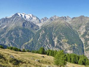
Gspon to Kreuzboden along the Gspon Hohenweg
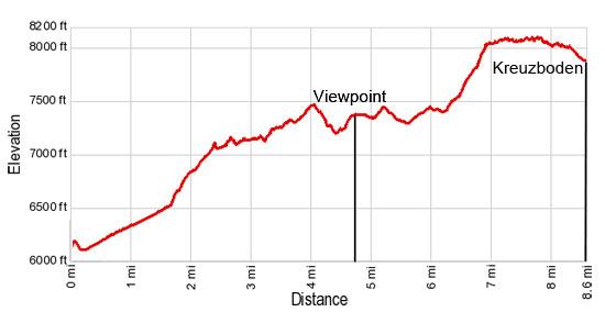
Note: Due to the up and down nature of the trail, the elevation gain and loss is much greater than it appears by simply looking at the trailhead elevation and the high point on the hike. Total elevation gain for the hike is 2,485-ft and the loss is 2,780-ft.
Take the bus from Saas Fee to the Stalden Bahnhof and then ride the two stage cable car to Gspon. (See trailhead directions below.) In Gspon (6,217-ft.) find the trail signs outside the lift station. Walk south/southeast along the cobbled track descending through the village toward Chrizbode (alternative spelling for Kreuzboden). Along the way enjoy fine views of the Mischabel Range, including the Balfrin, Lammerhorn, Bigerhorn and Seetalhorn, towering above the west side of the Saastal (Saas Valley). The Bernese Oberland peaks, including the distinctive triangular-shaped Bietschhorn, rise above the Rhone Valley to the north/northwest.
Reach at “Y” intersection at Ze Hiischinu (6,070-ft.) at 0.2 miles. Bear left on the dirt road in the direction of Chrizbode (Kreuzboden). The path branching to the right drops to Stalden. Beyond the intersection the road ascends through pastures on easy to moderate grades along the east side of the valley and soon enters the trees. After walking a little over a mile the trees thin and give way to meadows with nice views of the peaks across the valley.
At 1.7 miles arrive at Oberfinilu (6,690-ft.) where the trail splits. Bear left on the narrow track toward Chrizbode (Kreuzboden) that ascends through a small alp with a pretty little chapel and then enters the trees. After passing a trail branching left toward Richtung the ascent continues on moderate to steep grades. Note the trail signs now point you toward Kreuzboden (the alternative spelling).
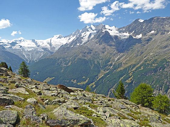
At 2.4 miles the trail starts traveling through an area scarred by landslides. Beyond the last slide the path climbs through trees up a rocky hillside to Schwarzwald (7,218-ft.) at 3.0 miles. Here a small alp/cafe is set amid lovely meadows with wonderful views of the Balfrin massif and the Mischabel Range. In the distance, a portion of the glacial cirque rising above Saas Fee is visible.
Beyond the meadows the trail briefly reenters the trees before descending rocky meadows to cross a stream at 3.4 miles. The path now ascends through trees, dipping in and out of minor gullies with small streams.
Reach a pasture at 3.9 miles with more great views across the valley. The trail ascends across the pasture, passing an old stone building and the remains of holding pens, before dropping down soggy slopes on moderately steep grades to cross a wood bridge over the Mattwaldbach (stream).
Past the bridge the trail climbs a series of switchbacks through a wooded area and then ascends a rockslide to emerge on a large, beautiful meadow at 4.7 miles. The meadows feature breathtaking views of the Mischabel Range. The Lammerhorn and Balfrin are now joined by the jagged profiles of the Taschhorn, Dom and Lenzspitze, the tallest peaks in the range. Further to the southwest the massive Fee Glacier spills down the slopes of the Allalinhorn and Alphubel. To the north are splendid views of the Bietschhorn.
The meadow is a great place for a picnic or to simply take a break and soak in the scene. When you are ready to continue, follow the trail as it wanders southeast across the meadows on easy grades and then travels through a forest of old larch and pine trees. Openings in the trees offer ever improving views of the Mischabel Range. In the distance Saas Grund sprawls along the valley floor while Saas Fee lies nestled in a hanging valley along the west side of the valley.
At 5.1 miles the path climbs briefly and then descends on moderate grades to a trail junction at Linde Bode (7,310-ft.) at 5.5 miles. Here a trail branches to the right (south) toward Saas-Balen and Saas Grund. We continue toward Kreuzboden, descending through meadows and then trees to a gravel road at 5.6 miles.
Follow the gravel road as it ascends southeast on easy grades, reaching a signed “Y” intersection at 6.0 miles. The trail to the left ascends toward Gletscher Seewjine and Sattel. We bear right toward Kreuzboden. Looking south, views open to the Mattmark area and the Schwarzberg Glacier at the head of the Saas Valley.
A short distance past the junction, reach Hoferalpi (7,415-ft.) where more signs point toward Kreuzboden. Soon the road passes to the right (south) of an alp with a restaurant. Shortly beyond the alp the trail dips into ravine, crosses a bridge over the Fellbach carrying glacial meltwater and then climbs out of the ravine. Past the ravine the path ascends steeply through pretty meadows to the tiny hamlet of Gruebe (7,546-ft.) at 6.5 miles.
The steep ascent through rocky meadows continues past Gruebe. Stunning views of the amazing cirque of 4,000-meter peaks, including the Allalinhorn, Alphubel, Taschhorn, Dom and Lenzspitze, surrounding the Saas Fee valley will help take your mind off the stiff climb. Huge glaciers cling to the flanks of the peaks while waterfalls fed by glacial meltwater gush down the mountainsides.
At 7.0 miles the grade abates as the trail reaches the massive boulder field along the southwest flanks for the Jegihorn. Trail crews have done an exceptional job of plotting a course through the rock. Grand views of the Mischabel range make it hard to keep your eyes on the trail.
Finally the rocks end and you arrive at Hannig (8,022-ft.), a popular viewpoint, at 8.0 miles. Here the trail turns left (northeast) and descends to Kreuzboden on moderate grades. Along the way enjoy views of the Lagginhorn and Weissmies towering above the Kreuzboden valley.
Reach the gondola at Kreuzboden (7,874-ft.) at 8.7 miles. Near the lift station is a playground, a small lake and a restaurant with a sun terrace offering sweeping views of the Mischabel Range. From Kreuzboden take the Kreuzboden Gondola down to Saas Grund and then catch a bus back to Saas Fee.
Alternatively, you can walk back to Saas Grund via Triftalp on a knee crunching trail that descends extremely steep switchbacks down a rugged hillside, losing 2,760-ft over 2.8 miles. My advice is to take the gondola and save your knees.
This walk is an easier and shorter alternative to the challenging Saas Fee Hohenweg across the valley, making it a good option for parties looking for a great hike with lovely views.
The trail can be walked in either direction, I recommend walking up valley, from Gspon to Kreuzboden, for the best views.
Elevation Profile
Driving Directions
From the Saas Fee Bus Terminal to Gspon: Take the bus bound for Brig and get off at the Stalden Bahnhof (train station). The ride takes 32 minutes. Walk across the train tracks to the Stalden- Gspon Luftseilbahn (Cable Car) station and buy a one-way ticket to Gspon. This is a two stage cable car that requires you to change cars at Stalden Reid. Note that the first stage of the cable car stops at a mid-station. Stay put until you get to Stalden Reid where you change to the cable car bound for Gspon. It is a very short walk to the connecting cable car and there is a short wait so you don’t need to rush while changing cars.
Returning to Saas Fee from Saas Grund: The bottom station for the Kreuzboden gondola is in Saas Grund. To return to Saas Fee, walk west from the gondola station to the main road. Cross the road and turn left to reach the post bus stop (located between the Hotel Bergheimat and the Alpen-Perle) A signpost with a post bus schedule marks the stop. Catch the bus heading to Saas Fee.
Trail Resources
Trail Intro / Trail Photo Gallery / Trail Map
Basecamp(s) Information:
Saas Fee
Region Information:
The Valais
Other Hiking Regions in:
Switzerland