Hike Facts
- Distance: 4.5 miles (round trip)
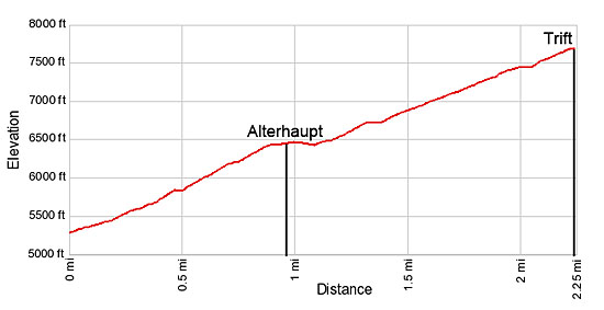
- Elevation: 5,325-ft. - 7,667-ft.
- Elevation Gain: 2,342-ft.
- Difficulty: moderate-strenuous
- Trail Highlights: See Trail Intro
- Basecamp(s): Zermatt
- Region: The Valais
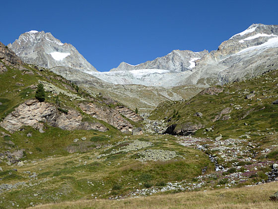
This lovely hike climbs steeply up the beautiful Trift Gorge beside a cascading stream, traveling through lovely wildflower-filled meadows to the basin at head of the gorge surrounded by a gorgeous cirque of rugged peaks adorn with glaciers.
Trift Hike
The Trift hike begins at the corner of Chrum and Bahnhofstrasse (the main street), a quarter mile south of the train station (Bahnhof), in Zermatt. (See directions below.) Start walking uphill on Chrum, a narrow alley. Signs a short distance up the alley indicate you are on Chrum and point toward the Trift, Alterhaupt, Hohbalm and Arbenbach trails.
Bear left where the alley splits and about 500-ft. further along turn left onto Triftweg, a paved walkway. (Look for a blue metal Triftweg sign embedded in the stone wall along the right side of the pavement.) The steep walkway initially climbs south but soon curves to the right (north/northwest) at the corner of the Omnia Hotel. Past the hotel the path turns into a dirt track ascending steeply through meadows with nice view of Zermatt.
The trail now climbs toward the Trift Gorge, the obvious cleft in the hillside carved by the waters of the Triftbach. Pass trail junctions at 0.3 miles and 0.5 miles. At each intersection continue in the direction of Trift and Alterhaupt (Edelweiss).
After a slight bit of downhill cross the Triftbach on a good wooden bridge and then ascend to join a track coming up from town. Turn right at the signed junction toward Alterhaupt (Edelweiss), Trift and the Hohbalmen, a popular viewpoint on the Hohbalm plateau.
Follow the trail as it climbs switchbacks through a forest of larch and fir trees, leaving the river briefly to circumvent a large rock outcropping. Arrive at the Alterhaupt (6,345-ft.) and the Café Edelweiss at 0.9 miles. This beautiful overlook enjoys bird’s-eye views of Zermatt and nice vistas of the Mattertal (Matter Valley) along with the Dom (14,911-ft.) and the Taschhorn (14,733-ft.) to the northeast.
Just beyond the restaurant the track splits. The trail to the left signed for Hohbalmen (2-hr) and Arbenbach (3-hr 40-min) is a shorter and steeper route to the Hohbalm plateau that is not recommended since it misses some spectacular scenery. Our trail toward Trift (1-hr 10-min) and the Wisshorn (3-hr 10-min) continues straight ahead up the gorge, ascending slightly before dropping gently down to the river (Triftbach).
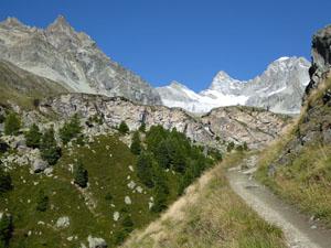
When the trail reaches the river it resumes its ascent up the gorge, crossing a bridge to the right (north) side of the Triftbach at 1.5 miles. As you climb, periodically turn around for good views of the Oberrothorn and the Monte Rosa massif across the Mattertal to the southeast.
During late July and early August the meadows along the gorge feature an impressive display of wildflowers. Signs along the way identify the flowers and describe their unique habitat. Keep an eye out for the elusive Edelweiss with its delicate white petals.
Not far beyond the bridge views open to the Wellenkuppe’s (12,805-ft.) snow covered summit rising above the head of the Trift Valley. With each step the views improve and soon the pyramid-shaped Ober Gabelhorn (13,330-ft.) joins the scene followed by the rugged crags of the Unter Gabelhorn (11,125-ft.).
Reach the Hotel du Trift (7,667-ft.) at 2.25 miles. The hotel, situated in a lovely alpine basin at the head of the gorge, is surrounded by a stunning cirque of high peaks and glaciers. Views (from right to left) encompass the Zinalrothorn (13,848-ft.), Trifthorn (12,230-ft.), Wellenkuppe, Ober Gabelhorn, Mittel Gabelhorn and Unter Gabelhorn. The Trift and Gabelhorn glaciers along with numerous snow fields adorn the flanks of the peaks. Turn around for equally impressive views of the Monte Rosa massif rising above Gornergrat (Gorner Ridge) to the southeast.
This is a great spot for a long break. The Trift Hotel provides 30 dormitory spaces and 9 private rooms along with beverages, snacks and meals. Picnic tables in front of the hotel offer front row seats to the panorama of peaks rising above the valley. Alternately, find a nice spot in the meadows to the west of the hotel to enjoy a picnic lunch and the terrific views.
The valley is the jumping off point for a number of longer hikes. Just beyond the hotel is a trail junction with signs point right toward the Wisshorn (2-hr) and the routes to the Rothhornhutte (2-hr 30-min), Platthorn (3-hr 05-m) and Mettelhorn (3-hr 40-min). A sign points left to the Hohbalm (1-hr 05min) and Schonbielhutte (4-hr 10-min) trail. We will leave these hikes for another day.
After enjoying the Trift area turn around and retrace your steps back to Zermatt for a 4.5 mile round-trip hike.
Elevation Profile
Driving Directions
From the Zermatt Bahnhof (Train Station): Walk south on Bahnhofstrasse, the main street, for 0.25 miles and turn right on Chrum, a small alley. Chrum is the first street on the right after the Mont Cervin Hotel (left).
From the Church in Zermatt: From the south end of town, walk to the church at the corner of Kirchstrasse and Bahnhofstrasse. Walk 0.15 miles (820-ft.) north on Bahnhofstrasse and turn left on Chrum, a small alley. Chrum is the first street on the left after the Hotel Monte Rosa.
Note: The Unique Hotel Post is located across from Chrum street. Gees Cockoo Club, with Grampi’s on the second floor, is located at the southeast corner of Bahnhofstrasse and Chrum.
As you head up the alley you will see signs indicating you are on Chrum and pointing toward the trails to Trift, Alterhaupt, Hohbalm and Arbenbach. At 0.1 miles the alley splits. Bear left at the split and about 500-ft. further along turn left onto Triftweg, a paved walkway, marked with a blue metal sign embedded in the stone wall running along the right side of the street. Follow the hiking directions above.
Trail Resources
Trail Intro / Trail Photo Gallery / Trail Map
Basecamp(s) Information:
Zermatt
Region Information:
The Valais
Other Hiking Regions in:
Switzerland