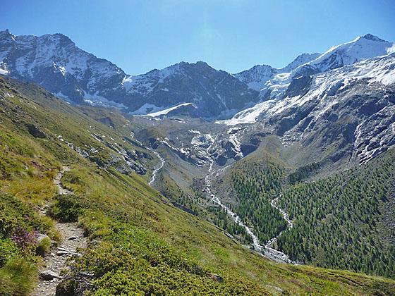
Weisshorn, Schalihorn and Zinalrothorn at the head of the valley
The long and strenuous climb to the Cabane Arpitetta features wonderful views of the glacial cirque at the head of the Arpitetta valley, dominated by the Weisshorn, Zinalrothorn, Moming massif and the Moming glacier.
See Trail Detail/Full Description
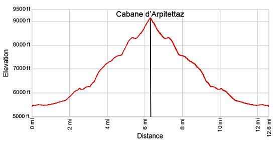
- Distance: 12.6 miles (round trip) to Cabane Arpitetta
- Elevation: 5,480-ft. at Trailhead
9,140-ft. at Cabane Arpitetta - Elevation Gain: 3,660-ft. to Cabane Arpitetta
- Difficulty: strenuous
- More Hikes in:
Zinal / The Valais
Why Hike Cabane Arpitetta
This great hike ascends the Arpitetta Valley to the Cabane Arpitetta, situated at the base of the Weisshorn's west face. Hikers making the steep climb to the hut are rewarded with glorious views of the large glacial cirque at the head of the Arpitetta Valley, dominated by the Weisshorn and Schalihorn to the east and the Zinalrothorn, Moming massif and Besso to the south. Two massive glaciers, the Moming and the Weisshorn spill down the flanks of the cirque.
Starting in Zinal, the trail travels up the Zinal Valley along La Navisence River with fine view of Besso rising to the east. Near the Petite Mountet hut the trail crosses the La Navisence to the east side of the Zinal Valley and then crosses the Torrent de l’Arpitetta to the north side of the Arpitetta Valley.
Beyond the crossings the path climbs steeply to Lac d'Arpitetta with wonderful views of the Weisshorn, Schalihorn, Pointe Sud de Moming, the Zinalrothorn, Blanc de Moming and Besso, in the Arpitetta Valley. To the south are views of the Pigne de la Le, the Grand Cornier, Dent Blanche and Pointe de Zinal towering above the west side of the Zinal Valley.
Beyond the lake the trail climbs up the north side of the valley on moderate to very steep grades beneath the south facing flanks of the Pointe d’Arpitetta. A final steep climb through rocky meadows leads to the hut with stunning panoramic views of the Weisshorn and nearby peaks forming the splendid cirque towering above the head of the valley. The massive Moming glacier tumbles down the flanks of the peaks to the south. The amphitheater is bookended by Besso to the southwest and the Pointe d’Arpitetta to the northwest.
This is a long, strenuous hike best undertaken by hikers who are well acclimated and fit. The hike can be extended by returning to Zinal via Roc de la Vache.
Elevation Profile
| Support our Site |
Trail Resources
Trail Detail/Full Description / Trail Photo Gallery / Trail Map
Basecamp(s) Information:
Zinal
Region Information:
The Valais
Other Hiking Regions in:
Switzerland