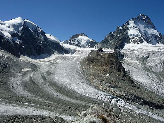
Mount Durand, Pointe de Zinal and Dent Blanche
Magnificent views of one of the most stunning glacial cirques in the Pennine Alps is the reward for hikers completing this long and very strenuous hike to the Cabane du Grand Mountet at the head of the Zinal Valley.
See Trail Detail/Full Description
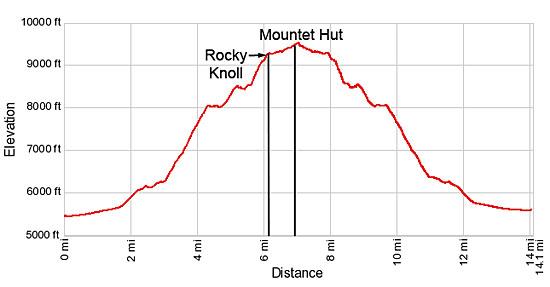
- Distance: 12.2 miles (round trip) to Rocky Knoll
14.1 miles (round trip) to Cabane du Grand Mountet - Elevation: 5,480-ft. at Trailhead
9,284-ft. at Rocky Knoll
9,520-ft. at Cabane du Grand Mountet - Elevation Gain: 3,804-ft. to Rocky Knoll
4,040-ft. to Cabane du Grand Mountet - Difficulty: strenuous-difficult
- More Hikes in:
Zinal / The Valais
Why Hike Cabane du Grand Mountet
At the head of the Zinal Valley is one of the most dramatic cirques in the Pennine Alps. A massive wall of high peaks including the Zinalrothorn, Ober Gabelhorn, Mont Durand, the Pointe de Zinal, Dent Blanche and the Grand Cornier tower above the head of the valley. Three large glaciers, the Grand Cornier, Durand and Mountet, tumble down the flanks of the peak and join to form the Zinal Glacier, a massive river of ice flowing along the valley floor. Smaller glaciers hang from ledges, glistening in the sun.
The Cabane du Grand Mountet lies at the base of this magnificent amphitheater, offering front row seats to a spectacular landscape of rock and ice. The long and strenuous trail to the hut permits day hikers entry into this splendid realm.
Starting in Zinal, the trail travels up the Zinal Valley along the La Navisence River with fine view of Besso rising to the east. Near the Petite Mountet hut the trail crosses the Navisence to the east side of the valley. Here views open to the Grand Cornier.
Now the real work begins as the trail climbs steeply up the east side of the valley and then follows an ascending traverse across steep slopes beneath Besso’s west face. As the trail progresses up the valley Dent Blanche and the Pointe de Zinal join the scene.
At 5.6 miles the trail starts an extremely steep climb, aided by switchbacks, up the rocky flanks of Besso’s northwest ridge. Fix chains offer handholds and a level of security as you haul yourself up rocky, exposed and extremely steep sections of the trail. After an exhausting climb the trail crosses Besso’s northwest ridge and views open to Mont Durand, the Ober Gabelhorn and the Wellenkuppe.
After crossing a boulder field the trail arrives at a rocky knoll, featuring stunning views of the ice-clad peaks stretching from the Grand Cornier to the Wellenkuppe, at 6.1 miles. Below the knoll the Zinal Glacier flows along the valley floor. This is a good turnaround point for many hikers.
Parties with the stamina, along with good weather, can continue ascending across boulder fields to the hut. Beyond the hut a use/social trail ascends to the crest of the moraine along the west side of the Mountet Glacier for breathtaking 270-degree views of the entire cirque, which now includes the Zinalrothorn and the Trifthorn. From this vantage point you are surrounded by towering mountains and rivers of ice flowing down the flanks of the rugged peaks and along the valley floor.
The day hike to the hut is only recommended for strong, well acclimated hikers. Pick a clear day, get a very early start and take plenty of food and drink. The hike will take longer than you expect. An overnight visit to the hut is a more viable proposition for many hikers and allows extra time to explore this amazing landscape.
Elevation Profile
| Support our Site |
Trail Resources
Trail Detail/Full Description / Trail Photo Gallery / Trail Map
Basecamp(s) Information:
Zinal
Region Information:
The Valais
Other Hiking Regions in:
Switzerland