Details: St. Luc / Hotel Weisshorn to Gruben via Meidpass 
Distance: 6.8 - 7.8 miles (one way)
near Zinal in The Valais
Hike Facts
- Distance: 6.8 - 7.8 miles (one way)
- Elevation: 7,145-ft. - 9,154-ft.
- Elevation Gain: 2,009-ft.
- Difficulty: moderate-strenuous
- Trail Highlights: See Trail Intro
- Basecamp(s): Zinal / Gruben
- Region: The Valais
Meidpass features splendid views of the glacier clad peaks of the Turtmann Valley, the summits towering above the Rhone, Anniviers and Moiry Valleys along with distant views of Grand Combin and Mont Blanc, rising to the southwest beyond the Anniviers Valley.
To Gruben via Meidpass
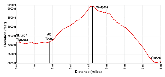
Elevation Information from St. Luc:
- Distance: 7.8 miles (one way)
- Trailhead Elevation: 7,145-ft.
- High Point at Meidpass: 9,154-ft.
- Ending Elevation at Gruben: 5,964-ft.
- Net Gain/Loss: +2,009-ft. / -3,190-ft.
Elevation Information from Hotel Weisshorn
- Distance: 6.8 miles (one way)
- Trailhead Elevation: 7,667-ft.
- High Point at Meidpass: 9,154-ft.
- Ending Elevation at Gruben: 5,964-ft.
- Net Gain/Loss: 1,487-ft. / - 3,190-ft.
The hike to Meidpass starts at either Tignousa, located at the top of the funicular station in St. Luc, or the Hotel Weisshorn, a circa 1880’s Victorian Hotel with panoramic views of the high peaks towering above the Rhone Valley and the Val Anniviers. Note: If you are unable to get into the Weisshorn or opt to skip that day on the Haute Route, you can stay either in Grimentz or Zinal and easily take a bus to St. Luc. (See trailhead directions below.)
Starting from St. Luc
In St. Luc, take the funicular to Tignousa (7,145-ft.). Outside the station find the trail signs and start hiking along the broad track heading southeast toward Meidpass and Gruben.
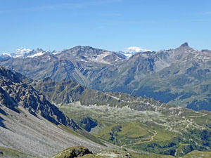
As you walk ignore the nearby ski lifts and pistes and instead focus on the great views to the south where the distinctively shape summit of the Matterhorn (14,692-ft.) towers above the peaks at the head of the Zinal Valley. To the southeast Les Diablons (11,840-ft.), the Bishorn (13,625-ft.) and the Weisshorn (14,783-ft.) rise above the ridge separating the Anniviers and Turtmanntal (Turtmann) valleys. Below the trail vistas stretch southwest to Grimentz at the foot of the Moiry Valley.
The path, known as the Planets trail, travels through meadows and forest around a shallow side valley, passing short spur paths leading to sculptures of the sun and the planets. The meadows offer fine views of the ridge rimming the west side of the Anniviers Valley and Les Diablerets, a flat topped peak, rising above the north side of the Rhone Valley. The white building setting atop a knoll across the valley is the Hotel Weisshorn.
At 0.8 miles pass a side trail at Chalet Blanc. A short distance beyond ignore trails branching right and dropping down to St. Luc. Reach the alp at Touno and a junction at 1.9 miles. Here we turn left toward Meidpass and Gruben.
Starting from the Hotel Weisshorn
Behind the Hotel Weisshorn find the signs pointing to Meidpass. The trail heads east, descending on easy grades through meadows. After 0.7 miles the trail curves to the north and soon reaches the alp at Touno and a junction at 0.9 miles. Here we turn right toward Meidpass and Gruben. For the remainder of this description the first number listed in the mileage is the distance is from the Hotel Weisshorn while the second number is the distance from Tignousa (the top of the funicular in St. Luc).
Touno to Gruben via Meidpass
The trail briefly ascends north past an alp building and then turns right (east/northeast), ascending steeply through pastures. The trail soon passes a hut and then continues climbing. At 1.5/2.5 miles the trail veers left and crosses a stream. Le Touno (9,898-ft.) rises above the trail to the south.
At 1.6/2.6 miles the grade eases a bit as the trail travels through an undulating landscape of meadows and low knolls, reaching a junction at 1.7/2.7 miles. Here a short spur trail branches right toward the Lac de Combavert (8,005-ft.). We continue toward Meidpass.
Soon views open left (north/northwest) to the jagged ridge of peaks rising above the north side of the Rhone valley. The ridge forms a lovely backdrop for a small tarn in the meadows a short distance from the trail. Ahead are views of the craggy ridge separating the Anniviers and Turtmann Valleys.
At 2.0/3.0 miles the ascent steepens and the landscape becomes more rugged as the path climbs through rocky meadows toward the ridge. The obvious saddle on the ridge is Meidpass. As you gain elevation the views continue to improve. Le Touno and the Point de Tourtemagne (10,138-ft.) rise to the south. To the north are the peaks rimming the Rhone Valley. Turn around periodically for panoramic views of Sasseneire (10,675-ft.) and Bes de Bosson (10,330-ft.) towering above the Val de Moiry and Grimentz.
At 2.7/3.7 miles reach a junction with a trail branching toward Lac de l'Armina. We bear right toward Meidpass. The trail now climbs steeply up scree covered slopes and rocky meadows. Switchbacks facilitate the ascent. Turn around for panoramic views to the southwest. On a clear day you should be able the see the summits stretching from the Grand Combin (14,154-ft.) to Mont Blanc (15,777-ft.).
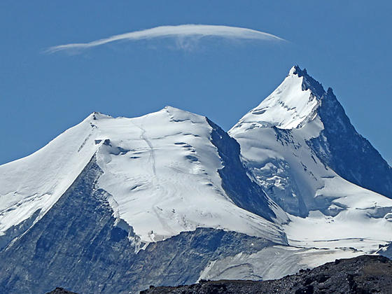
Reach Meidpass (9,154-ft.) at 3.2/4.2 miles. As you top the pass views unfold southeast to the glacier-clad Brunegghorn (12,575-ft.), Bishorn (13,625-ft.) and Weisshorn (14,783-ft.) soaring above the intervening ridge of craggy peaks. The Dom (14,911-ft.) and the Taschhorn (14,734-ft.), located in the Mattetal Valley to the east, rise above the ridge rimming the east side of the Turtmann Valley.
Turn around for more amazing view of the high peaks, including the Grand Combin and Mont Blanc, rising beyond the western ridges rimming the Moiry and Anniviers valleys. To the north/northwest a sea of peaks fills the skyline above the Rhone Valley. Rugged crags rise along the ridge above the pass, Aiguilles du Meiden (9,629-ft.) (aka Meidspitz), to the north, and the Pigne de Combavert (9,419-ft.), to the south.
On a beautiful day it is difficult to pull yourself away from this scenic pass. To continue to Gruben, descend the east side of the pass on steep grades, traveling through scree covered slopes and rocky meadows. At 3.5/4.5 miles the grade abates as the path crosses the bowl beneath the Aiguilles du Meiden and Rotighorn (9,708-ft.).
At 3.8/4.8 miles the trail veers right (southeast), skirting the slopes above the west side of the Meidsee (8,730-ft.). This tarn, set in a rocky bowl, is a favorite spot for hikers to take a break, especially if it is windy at the pass.
At 4.0/5.0 miles the trail starts a steep descent down the east side of the Turtmann Valley dropping through meadows and then pastures. At 4.4/5.4 miles the grade moderates before resuming its steep descent at 4.9/5.9 miles.
At 5.25/6.25 miles pass through Meiden Oberstafel and reach a junction. We bear left on the trail toward Gruben. The turn is marked with a small stones painted with red and white slashes. The wide track/road to the right heads toward the Stausee and the Turtmannhutte at the head of the valley.
The trail now descends through pastures with terrific views of the Turtmann Glacier spilling down the slopes between Les Diablons, Tete de Milon and the Bishorn at the head of the valley. The spike rising behind the Bishorn is the Weisshorn.
At 5.4/6.4 miles the trail crosses the road above Mittelstafel, a group of alp buildings seen below the trail. Continue straight ahead on the trail toward Gruben, which descends through meadows, passes through Mittelstafel and then turns left (northeast) at 5.5/6.5 miles, dropping through meadows that give way to trees.
At 5.7/6.7 miles the trail curves to the right (south/southeast), descending through viewless forest to the main road through Gruben at 6.5/7.5 miles. Turn left on the road and walk by summer homes. Ahead you will see a multi-story stone building. This is the Hotel Schwarzhorn. A road on a diagonal veers off the main road and ascends to the hotel at 6.8/7.8 miles. Total elevation loss from the pass to Gruben is 3,190-ft.
The quiet little Turtmann valley feels like a place where time has stood still, harkening back to the days before upscale ski resorts littered the mountain regions of Switzerland. There is a small shop in the Hotel Schwarzhorn where you can buy snacks. My advice is stock up on all needed supplies before leaving the Anniviers Valley.
Transportation in and out of Gruben is very limited. A van runs between the Hotel Schwarzhorn and the Silbahn (Cable car) in Oberems. From the bottom station of the cable car it is a 10 minute walk to the Turtmann train station, a local stop in the Rhone Valley with connections to Visp in the east and Sion in the west. This is the best escape route if the weather is too bad to proceed over Augstbord Pass.
The time table for the bus and cable car are available on the SBB site. (See the SBB website or download the app for the current schedules.) Note: There are two towns called Gruben in Switzerland. When using the SBB site choose Gruben (VS) as the destination.
The Hotel Schwarzhorn, only open in the summer and early fall, includes 15 private rooms and dormitory accommodations. Meals, snacks and drinks are available in the hotel’s cafe.
Elevation Profile
Driving Directions
From Zinal to St Luc, Bella Tola: From the post office in Zinal, board bus #453 bound for Vissoie. At Vissoie Post, change to Bus 454 to Chandolin, Poste. Get off the buss in St. Luc at the Bella Tola stop. The bus ride takes 48 minutes.
From Grimentz to St Luc, Bella Tola: From the post office in Grimentz, board bus #452 bound for Vissoie Poste. At Vissoie Post, change to Bus 454 to Chandolin, Poste. Get off the buss in St. Luc at the Bella Tola stop. The bus ride takes 46-53 minutes.
Walk south from the Bella Tola bus stop (in the direction the bus is traveling) along the main road. Soon you will reach a hairpin curve. Exit the main road and follow the Route Vieux Village toward the funicular. You will see blue signs for the funicular marking the route. At the next intersection bear left, continuing to follow the signs. Pass a small side street on the left, the Rue du Cervin. At the next street bear left and in a short distance turn right on the Route de Funiculaire. Again, all of these turns are marked with signs. Walk up the road (Route de Funiculaire) to the funicular station on your left. The walk should take about 9 minutes.
See the SBB website or download the app for the current schedules. See the Val Anniviers website for more information about the St. Luc Funicular schedule.
Trail Resources
Trail Intro / Trail Photo Gallery / Trail Map
Basecamp(s) Information:
Zinal / Gruben
Region Information:
The Valais
Other Hiking Regions in:
Switzerland