Details: Cabane de Moiry to Zinal via Col de Sorebois 
Distance: 7.5 - 9.9 miles (one way)
Valais, near Zinal in The Valais
Hike Facts
- Distance: 7.5 - 9.9 miles (one way)
- Elevation: 9,268-ft. - 9,374-ft.
- Elevation Gain: 1,574-ft.
- Difficulty: moderate-strenuous
- Trail Highlights: See Trail Intro
- Basecamp(s): Zinal
- Region: The Valais
This hike, part of the Haute Route, also makes for a great point to point day hike with lovely views of the Zinal and Moiry Valleys along with dramatic up-close views of the Moiry Glacier. The hike can be walked in either direction.
Cabane de Moiry to Sorebois via the Col de Sorebois
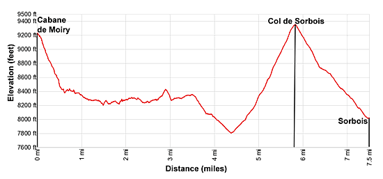
Elevation Information:
- Distance from Trailhead: 7.5 miles
- Elevation at the Cabane de Moiry: 9,268-ft.
Low Point on the Hike: 7,800-ft.
Col de Sorebois: 9,374-ft.
Sorebois: 8,000-ft.
Zinal: 5,450-ft. - Elevation Gain/Loss to Sorebois: 1,574-ft. / -2,834-ft.
Gain/Loss to Zinal: 1,574-ft. / -5,392-ft.
This description assumes you spent the night at the Cabane de Moiry. Day hikers will need to first climb to the hut, which adds 1.9 miles and 1,534-ft. in elevation to the hike. See the Cabane de Moiry hiking description for more information.
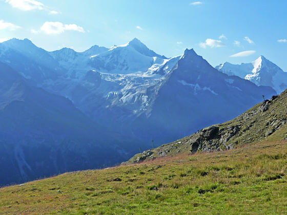
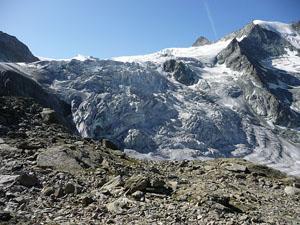
The Cabane de Moiry (9,268-ft.) sits atop a rocky knoll with dramatic views of the Moiry Glacier and the high peaks towering above the valley to the west including the Pointes de Mourti, Tsa de l’Ano and Pointe de Moiry. Pigne de la Le dominates the view to the south.
From the hut the trail descends from the knoll and then drops down very steep switchbacks on slopes covered with boulders and rocky meadows, losing 800-ft. in half a mile. At 0.7 miles the grades abates as the path descends through scree to the right (east) of the lateral moraine of the Moiry Glacier.
Soon the trail climbs to and then descends along the moraine crest accompanied by fine views of the glacier and the ridge rimming the west side of the valley. Turn right at 1.3 miles when you reach the junction with the Haut Tour du Lac – Chemin 2500 toward the Barrage de Moiry, Sorebois and Zinal. (The trail straight ahead descends to the parking lot at the foot of Moiry Glacier where buses depart for Grimentz and Zinal.)
The Chemin 2500 is an undulating path that contours high above the east side of the valley at around 2,500-meters (8,200-ft.). Before starting on the trail turn around for fine views of the Moiry Glacier flowing down the north face of the Grand Cornier at the head of the valley. The tip of Dent Blanche rises beyond the Grand Cornier. Across the valley the rugged ridge rimming the west side of the valley dominates the view. Below is the small lake at the foot of the glacier.
The path now heads northwest, curving around a ridge extending from the Garde de Bordon (10,860-ft.). At 2.0 miles pass a trail dropping steeply down to the road running along the east side of the lake. This path also connects with the trail traversing the lake’s western shore and the road around the eastern shore. Ahead are ever improving views of the Lac de Moiry and Sasseneire (10,675-ft.) and Diablon (10,016-ft.) rising to the northwest above the head of the lake.
At 2.6 miles the path rounds the end of the Bordon ridge and we lose our views of the Moiry Glacier. Instead we now look down the full length of the lake and enjoy fine views of the peaks rising to the west/northwest.
At 2.8 miles the trail briefly climbs up a hillside, crosses a rugged stream bed and then drops down a gully beside the stream to avoid a steep, eroded section of the hillside. At 3.1 miles the descent ends and the path resumes its undulating traverse along the hillside.
After a half mile of easy walking the path begins to descend on moderate grades, reaching a junction at 4.4 miles. Here a path, branching left, zig-zags down the hillside to the road at the foot of the Moiry Lake. A short distance beyond is a cafe and bus stop adjacent to the dam at the foot of the lake. In the summer regularly scheduled buses leave from the dam to Grimentz and Zinal.
We turn right at the junction, climbing over 1,500-ft. up steep switchbacks to the Col de Sorebois (9,374-ft.) at 5.8 miles. The pass, located on the ridge separating the Val de Moiry from the Val de Zinal, enjoys fine views of the Weisshorn, Zinalrothorn and Ober Gabelhorn to the southeast. To the southwest, the Bouquetins, Aiguille de la Tsa, Dents de Veisivi, Pigne d'Arolla, Mont Blanc de Cheillon, Grand Combin and Aiguilles Rouges d'Arolla rise beyond the ridge separating the Val de Moiry from Val de Herens. Below the Col, Lac de Moiry sprawls along the floor of the Val de Moiry. Sasseneire, Sex de Marinda and Bec de Bosson fill the skyline to the west. Garde de Bordon rises along the ridge to the south of the Col. Unfortunately views of the peaks towering above the head of the Val de Moiry are mostly blocked by a ridge of the Garde de Bordon.
Hikers with the time and energy can make the short side trip to the summit of the Corne de Sorebois (9,501-ft.), which features terrific 360-degree views that include the Bernese Alps to the north.
When you are done taking in the views descend from the Col on steep to moderately steep grades through pastures on a combination of ski services roads and trails. (The trails cutoff meanders along the road.) The pastures unfortunately are marred by ski apparatus.
Ignore the ski area and instead focus on the stunning views of the glacier-clad summits of the Weisshorn, Zinalrothorn, Besso and Ober Gabelhorn soaring above the east side of the valley. Garde de Bordon rises above the west side of the Zinal Valley. A segment of the road/trail drops down the east ridge of the Corne de Sorebois. Here we enjoy views that stretch north up the Val d’Anniviers to the Rhone Valley.
If you are not watching it is easy to miss some of the cutoff trails. This is hardly a big deal and does not make a substantial difference in the overall mileage.
Reach Sorebois at 7.5 miles. Here you will find a restaurant, bathrooms and a gondola descending to Zinal. If you wish to walk to Zinal, head south from the lift station on a signed road toward Zinal. After 0.2 miles watch for a trail, signed for Zinal, branching left. The path descends steep switchbacks, losing 2,700-ft. in 2.4 miles for a 9.9 mile walk from the Cabane de Moiry to Zinal. If you miss the turn you can follow the road down. The road is longer and not as steep but shared with mountain bikes. If your budget allows, my advice is to take lift down, saving your knees and energy for tomorrow’s walk.
Elevation Profile
Driving Directions
From the Sorebois Cable Car to Zinal Center: Take the cable car from Sorebois to Zinal. At the bottom station of the Zinal Telepherique, Cable Car station, walk south along the main street for a short distance. Just past the post office you will find grocery stores, restaurants and various types of accommodations.
From the Sorebois Cable Car to Grimentz: From the Zinal Telepherique (Cable Car station) walk south to the Zinal Post. From the Zinal Post board a bus bound for Grimentz. If possible catch a direct bus to Grimentz. Otherwise, take the Vissoie Bus to Vissoie where you will need to change for a bus heading to Grimentz. The direct buses take about 15 minutes. If you need to change in Vissoie the ride will take 58 minutes.
From the Moiry Barrage to Grimentz or Zinal: If you hit bad weather it might make sense to take the bus to Zinal or Grimentz instead of trying to cross the Col. At the glacier parking lot or the dam at the foot of the lake, board a bus headed toward Zinal or Vissoie. There are several stops in Grimentz, about a 20 minute ride from the dam. If you are headed to Zinal, the best bet is to catch a bus heading directly to Zinal. Otherwise, take the Vissoie Bus to Vissoie where you will need to change for a bus going up valley to Zinal. The direct buses take a little over a half hour. If you need to change the ride will take an hour and 15 minute or more, depending on the time of day.
Bus schedules are posted at the bus stops in Zinal, Grimentz and at the dam and are also available online at the SBB website or the SBB app.
Trail Resources
Trail Intro / Trail Photo Gallery / Trail Map
Basecamp(s) Information:
Zinal
Region Information:
The Valais
Other Hiking Regions in:
Switzerland