Details: Sorebois to Lac de Moiry via Col de Sorebois 
Distance: 5.6 - 8.9 miles (one way)
near Zinal in The Valais
By: Diane Greer
Hike Facts
- Distance: 5.6 - 8.9 miles (one way)
- Elevation: 8,000-ft. - 9,374-ft.
- Elevation Gain: 2,000-ft.
- Difficulty: moderate
- Trail Highlights: See Trail Intro
- Basecamp(s): Zinal
- Region: The Valais
Climb to the Col de Sorebois and then travel high above the Lac de Moiry to the Moiry Glacier. The walk is accompanied by fine views of the peaks towering above the Zinal, Moiry and Arolla valleys. Extend the hike by visiting the Moiry Hut or walking back along the lake to the dam.
Sorebois to the Moiry Glacier via Col de Sorebois
Distance from Trailhead: 5.6 miles (one way)
Ending/Highest Elevation: 9,374-ft.
Elevation Gain: 2,000-ft.
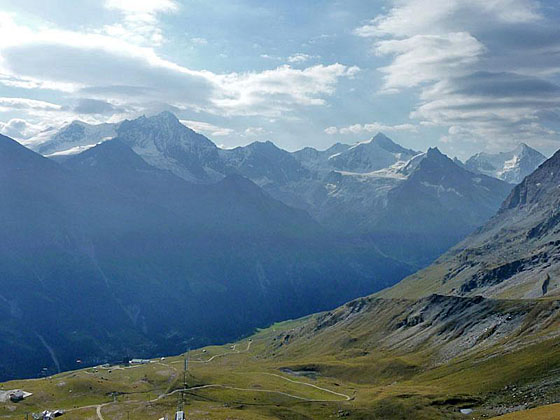
Take the cable car from Zinal to Sorebois (8,000-ft.) situated high above the west side of the Zinal valley. (See trailhead directions below.) Exit the lift and find the trail signs behind the lift station. Walk west on a dirt road toward the Corne de Sorebois (1-h4 20-min) and the Lac de Moiry (2-hr 20-min), ascending on moderate grades through pastures marred with ski apparatus. As you ascend enjoy great views of the high peaks towering above the east side of the Zinal valley including the Weisshorn, Schalihorn, Zinalrothorn, Besso and Ober Gabelhorn.
After a half mile the trail curves to the right (north). Soon views open south to the Garde de Bordon towering along the ridge separating Zinal Valley from the Val de Moiry (Moiry Valley). The grade steepens as the trail climbs to the top of a ridge extending east from the Corne de Sorebois at 1.2 miles. From atop the ridge, views stretch north up the Val d’Anniviers to the Bernese Alps.
The trail now turns left (west) and climbs steeply along the south face of the ridge, slightly below the ridge crest. Soon the path curves to the left (southwest), ascending along the east facing slopes below the Corne de Sorebois to the Col de Sorebois (9,301-ft.) at 1.8 miles.
The pass, on the ridge separate the Val de Moriy from the Val de Zinal, enjoys fine views of the Weisshorn, Zinalrothorn and Ober Gabelhorn to the southeast. In the distance to the southwest, summits in the valleys to the west, including the Bouquetins, Aiguille de la Tsa, Dents de Veisivi, Pigne d'Arolla, Mont Blanc de Cheillon, the Grand Combin and Aiguilles Rouges d'Arolla, rise beyond the ridge separating the Val de Moriy from Val de Herens. Below the pass the Lac de Moiry sprawls along the floor of the Val de Moiry. Sasseneire, Sex de Marinda and Bec de Bosson fill the skyline to the west. Garde de Bordon rises along the ridge to the south of the Col. Unfortunately views of the peaks rising at the head of the Val de Moiry are mostly blocked by a ridge of the Garde de Bordon extending into the Moiry valley.
Hikers with the time and energy can make the short side trip to the summit of the Corne de Sorebois (9,574-ft.), which features terrific 360-degree views that include the Bernese Alps to the north.
From the pass the trail drops down the west side of the ridge on steep switchback to a trail junction at 3.1 miles, losing 1,500-ft. from the Col. At the junction turn left on the trail called the Haut Tour de Lac 2500, which heads south toward the Moiry Glacier (2-hr 30-min) and the Cabane de Moiry (4-hr). The trail branching right descends on steep switchbacks to the dam (barrage) at the foot of the Lac de Moiry where buses return to Grimentz and Zinal.
Our path ascends along the eastern slopes of the Val de Moiry high above the lake. At 4.0 miles the grade abates as the trail contours along the hillside. After a half mile of easy walking the trail briefly climbs up a gully beside a stream to avoid an eroded section of the hillside. Soon the trail crosses the stream and reaches the high point along the trail before dropping a short distance down the slope.
The path now traverses the west facing slopes of the Garde de Bordon, curving to the southwest and then south. To southwest are nice views of the Pointes de Mourti, Pointe de Moiry and Couronne de Breona.
At 5.0 miles the path rounds a minor ridge and curves to the southeast. The Moiry Glacier, flowing down the north face of the Grand Cornier at the head of the valley, springs into view. The tip of Dent Blanche rises beyond the Grand Cornier. Pigne de la Le towers above the glacier to the east.
Reach a “Y” intersection (8,235-ft.) at 5.6 miles. The trail branching left contours along the hillside and soon joins the trail ascending to the Cabane de Moiry in 0.8 miles. Take the trail to the right that drops down steep switchbacks to the Lac de Chateaupre, the lake near the foot of the Moiry Glacier. From the lake views extend southeast to the Moiry Glacier along with the Pointes de Mourti and Pointe de Moiry, rising to the west of the river of ice.
After enjoying the views, turnaround and head north to the Moiry Glacier parking lot. Here buses return to the dam (barrage) at the foot of Lac de Moiry, Grimentz and Zinal. Alternatively, hikers can opt to walk back to the dam on the trail along the west side of the lake.
See the description of the hike to the Cabane de Moiry for more information on visiting this scenic hut with terrific views of the Moiry Glacier.
From Moiry Glacier to Lac de Moiry Barrage
Distance from Trailhead: 8.9 miles (one way)
Ending/Highest Elevation: 7,380-ft.
Elevation Gain: -343-ft.
To return to the Moiry dam along the west side of the lake, walk north/northwest from the Moiry Glacier parking lot for 0.2 miles to a trail junction on the west side of the road at 6.25 miles. Take the trail branching left (northwest) that drops steeply through meadows and then travels on easy grades along the right (east) side of the outlet stream for Lac de Chateaupre. Along the way pass a trail branching right and climbing to the road.
Rock hop across the stream at 6.6 miles and then follow the trail as it cuts across meadows to the southwest end of the Lac de Moiry at 6.9 miles. Nice views extend north across the aquamarine lake to Sasseneire rising to the west above the dam. Turn around for fine views of the Moiry Glacier. The tip of the Grand Cornier peeks above the ice sheet.
The trail now drops down to the lake and heads north, traveling along the west side of the lake shore on easy grades. Turn around occasionally for views of the glacier. Soon you will see the tip of Dent Blanche appear to the south of the Grand Cornier.
A rocky outcropping near the foot of the lake forces the trail to climb to meet a road at 8.4 miles. After walking a short distance along the road the trail drops down to the west end of the Barrage de Moiry (7,380-ft.) at 8.5 miles. Here signs point north to a trail dropping steeply down to Grimentz (1-hr 40-min), losing over 2,250-ft. in 3.8 miles.
We turn right (east) and walk cross the top of the dam on a wide paved road. Along the way enjoy fine views that stretch up the length of the lake to the Moiry Glacier. Reach the cafe and bus stop at the east end of the dam at 8.9 miles. During the summer regularly scheduled buses depart for Grimentz and Zinal. Buses also travel south to the Glacier Parking area at the head of Lac Moiry
Note: This hike can be done in either direction. I prefer starting the hike at Sorebois so that I get over the Col de Sorebois in the morning when skies are typically clear. Clouds are more likely to obscure views of the glacier and surrounding peaks in the afternoon.
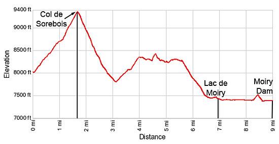
Elevation Profile
Driving Directions
From Zinal to the Sorebois Cable Car: From the post office in Zinal, walk north along the main street for a short distance to the Zinal Telepherique (Cable Car station) and take the cable car to Sorebois.
From Grimentz to the Sorebois Cable Car: From Grimentz, board the bus to Zinal and get off at the Zinal post office stop. From the post office, walk north along the main street for a short distance to the Zinal Telepherique (Cable Car station) and take the cable car to Sorebois
If possible catch a direct bus to Zinal. Otherwise, take the Vissoie Bus to Vissoie where you will need to change for a bus headed up valley to Zinal. The direct buses take 15 minutes. If you need to change in Vissoie the ride will take 58 minutes.
Buses make several stops in Grimentz. Schedules are posted at the bus stops and are available online at the SBB website and the SBB app.
From the Moiry Barrage to Grimentz or Zinal: At the dam, board a bus headed toward Zinal or Vissoie. There are several stops in Grimentz, about a 20 minute ride from the dam. If you are headed to Zinal, the best bet is to catch a bus heading directly to Zinal. Otherwise, take the Vissoie Bus to Vissoie where you will need to change for a bus headed up valley to Zinal. The direct buses take a little over a half hour. If you need to change the ride will take an hour and 15 minute or more, depending on the time of day. Schedules are posted at the bus stop by the dam and are available online at the SBB website and the SBB app.
Trail Resources
Trail Intro / Trail Photo Gallery / Trail Map
Basecamp(s) Information:
Zinal
Region Information:
The Valais
Other Hiking Regions in:
Switzerland