Cassidy Arch 
Distance: 3.4 miles
Fruita District, Capitol Reef National Park, near Capitol Reef in South Central Utah
By: Diane Greer
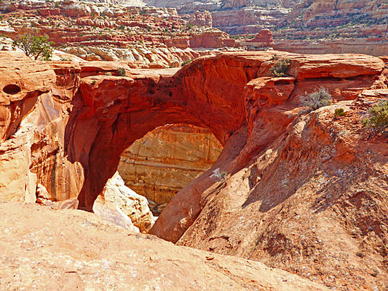
Cassidy Arch
A steep climb up the north wall of Grand Wash leads to a spur trail that ascends to an overlook above photogenic Cassidy Arch, spanning a large chasm. The trail is quite scenic with fine views of the colorful sandstone formation in the heart of Capitol Reef.
- Distance: 3.4 miles (RT)
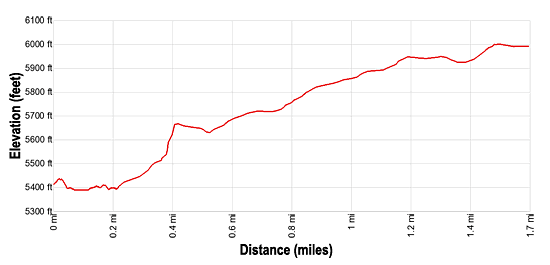
- Elevation: 5,390-ft. at Trailhead
Maximum elevation - 6,000-ft. - Elevation Gain: 610-ft.
- Difficulty: moderate-strenuous
- Basecamp: Capitol Reef
- Region: South Central Utah
Trail Description - Cassidy Arch
The trail to Cassidy Arch begins with an easy walk down the Grand Wash. From the northeast end of the Grand Wash trailhead parking lot (see driving directions below), the path heads east along a bench on the north side of the wash for 0.1 miles and then drops down to and continues along the wash. At 0.25 miles reach a signed junction on the left (north) side of the wash marking the start of the Cassidy Arch and Fryingpan trails.
Turn left and follow the Cassidy Arch trail as it climbs switchbacks and slickrock ramps on moderate to strenuous grades through colorful Wingate sandstone. The trail is now heading generally west as if curves in and out of side canyons, echoing the contours of the Grand Wash.
As you ascend enjoy fine views of the south wall of Grand Wash and the formations along the side canyons. There is one section of the trail with some exposure but the trail is wide enough to make most people feel comfortable.
The grade abates at 1.0 miles as you reach the top of the Kayenta sandstone. White Navajo sandstone domes and blocks tower above the trail to the north.
The trail soon curves to the right around a low knoll. Look west to see Cassidy Arch, located in a red band of rock on the west walls of a side canyon.
At 1.30 miles reach a signed junction where the Fryingpan trail continues straight ahead. Here we bear left on the trail to Cassidy Arch. A cairned route now curves around to the left to circumvent a deep chasm and then turns left (south) on an undulating route that initially descends and then ascending across a slickrock expanse. Keep track of the rock cairns to the stay on the trail.
Toward the end of the trail the route descends slightly to a spot where you can look down upon the Cassidy Arch at 1.7 miles. The arch, situated in a deep cavity, is named after Butch Cassidy, who is thought to have used Grand Wash as a hide out. Use care around the sheer drop-offs at the edge of the cavity. Around you are terrific views of the white domes and block set atop tilted layers of multi-hued sandstone.
When you are done admiring the arch and surrounding views, retrace your steps to the trailhead for a 3.4 mile round-trip walk.
Elevation Profile
Driving Directions
Capitol Reef Visitor Center to Grand Wash Trailhead: Turn right out of the Visitor Center on Campground Road/Scenic Drive. Follow Scenic Drive for 3.4 miles and then turn left onto the Grand Wash Road. Drive 1.3 miles on the good dirt road to the Grand Wash/Cassidy Arch trailhead parking area, located on the end of the road.
Trail Resources
- Trail Photo Gallery
- Trail Maps
- Basecamp(s) Information: Capitol Reef
- Region Information: South Central Utah
- Other Hiking Regions in: Utah