Natural Bridges Loop 
Distance: 8.6 miles (loop)
Natural Bridges National Monument, near Blanding in Southeast Utah
By: Diane Greer
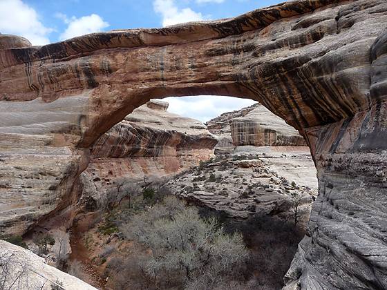
Sipapu Bridge from the trail climbing to to the rim.
This great loop hike in Natural Bridges National Monument visits three majestic natural bridges, crosses a high desert landscape and wanders along two scenic canyons with rock art panels and ancestral Puebloan ruins.
See Trail Detail/Full Description
- Distance: 8.6 miles (loop)
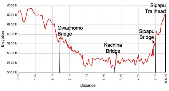
- Elevation: 6,210-ft. at Trailhead
Maximum elevation: 6,210-ft. - Elevation Gain: 560-ft.
- Difficulty: moderate
- More Hikes in:
Bears Ears NM / Natural Bridges NM / Southeast Utah
Why Hike Natural Bridges Loop
Natural Bridges National Monument (6,200-ft), situated high atop Cedar Mesa, illustrates the power of water in shaping a high desert landscape. Intermittent streams have cut two deep canyons and three massive bridges in sandstone formed from what was once the shore of an ancient sea that covered the area.
Trails, starting on the mesa, descend into the canyons to the bridges, named "Kachina," "Owachomo" and "Sipapu" in honor of the Native Americans that once lived in the area. A longer trail meanders along the bottom of scenic White and Armstrong Canyons and across the mesa, connecting the three bridges in a great 8.6 mile loop hike. Along the way the trail passes rock art panels and the ruins of ancestral Puebloan cliff dwellings.
Shorter look hikes between Kachina and Sipapu (5.7 miles round trip) and Owachomo and Kachina (6.5 miles round trip) are good options for hikers with limited time, as are the trails that descend from the rim to each of the bridges. From the rim a steep trail descends to Sipapu in 1.2 miles round trip, a moderately steep trail drops from the rim to Kachina in 1.4 miles round trip and a moderately-easy trail descend from the rim to Owachomo in 0.4 miles round trip.
The best time to hike the loop is in the spring and fall when temperatures are milder. During the summer temperatures often exceed 100 degrees. Hiking in the winter can be problematic due to ice on the trails.
Be sure to stop in the Visitor Center before you start hiking to pick up a map and get information on current conditions. Carry plenty of water. Do not depend on finding water in the canyons.
Elevation Profile
Trail Resources
Trail Detail/Full Description / Trail Photo Gallery / Trail Map
Basecamp(s) Information:
Bears Ears NM / Natural Bridges NM
Region Information:
Southeast Utah
Other Hiking Regions in:
Utah