Details: Lower Butler Wash 
Distance: 3.0 - 5.4 miles (round trip)
BLM, Monticello, Utah office, near Bluff in Southeast Utah
Hike Facts
- Distance: 3.0 - 5.4 miles (round trip)
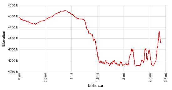
- Elevation: 4,480-ft. - 4,270-ft.
- Elevation Gain: -210-ft.
- Difficulty: easy-moderate
- Trail Highlights: See Trail Intro
- Basecamp(s): Bluff / Blanding
- Region: Southeast Utah
This short, moderately-easy hike leads to a stunning rock art panel along the north side of the San Juan River.
To Lower Butler Wash
Note: The mileage for this hike assumes you are starting from the 4WD parking area. Hikers starting from the 2WD parking spot near the drill hole should add 1.2 miles to the mileage listed below.
The trail starts off the Bluff Airport Road, 4.2 miles from Bluff, Utah. (See driving directions below.) From the 2WD parking area at the drill hole, walk southwest on easy grades along the unmarked dirt road for 1.2 miles to its end at a large expanse of slickrock near the rim of Lower Butler Wash. This is the parking area for 4WD vehicles.
From the 4WD parking area, walk southwest across the slickrock to the rim of Lower Butler Wash. At the rim an old wagon road descends south/southwest on moderate grades down the canyon’s eastern wall. A switchback, encountered at 0.2 miles, facilitates the decent. Reach the floor of the wash after losing 200-ft in 0.4 miles.
In the canyon follow the boot beaten path as it travels along the bench to the east of the wash. The wash is clogged with tamarisks, russian olives, willows and a few cottonwood trees. A short distance after passing a side canyon to the right (west) you will see an alcove sheltering a few ruins along the canyon’s west wall. The alcove is located at 0.8 miles (2.0 miles from the 2WD parking area).
At 0.9 miles the trail crosses to the west side of the wash and then crosses back again at 1.0 mile. Just beyond the second crossing you will see a spur trail on the right leading to a petroglyph panel. More petroglyphs are located along the eastern wall at 1.1 and along the western wall at 1.2 miles.
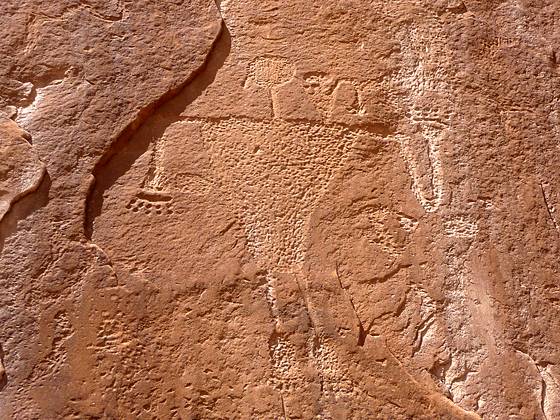
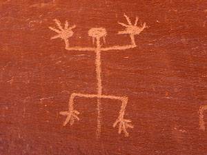
Reach the confluence of Lower Butler Wash and the San Juan River at 1.4 miles (2.6 miles from the 2WD parking area). Here the trail curves to the left (east) where you will find the large Butler Wash Petroglyph Panel along the cliffs on the north side of the river. The long panel, a popular stop for rafters floating the San Juan River, includes hundreds of petroglyphs of animals, humans, plants and geometric figures that date back to the Basketmaker period.
The longer you look at the cliff face the more figures you will see. Some of the figures are at eye level and others are high up on the rock face. Trails run along the length of the panel allowing close up views of the images.
Please remember that rock art is very fragile and easily damaged. Do not touch or tamper with the images in any way. Never touch rock panels as the oil on your fingers can speed the erosion of the rock art. Do not vandalize the panels by taking latex mold prints or rubbings from rock art or adding modern additions. This is a truly amazing panel. Treat it with respect so that it may be enjoyed by future generations.
After enjoying the panel and views of the San Juan River reverse your route back to the trailhead.
Elevation Profile
Driving Directions
From Bluff: Drive southwest on US-191 S for 4.2 miles. Where US-191 turns south, continue straight ahead on US 162 for 0.9 miles and turn left on County Road 269A / Bluff Airport Road. The road is located between mile posts 40 and 41 and is right across from the Butler Wash Road. Follow the road south for 0.2 miles and turn right (southwest) on an unmarked dirt road. (There is an old drill hole at the intersection with plenty of room for parking.)
Hikers with 2WD vehicle will want to park at the drill hole or follow the road for 0.2 miles to a wide area off the road and park. This second parking area is right before the road makes a wide curve to the right to avoid a large area of slickrock.
Hikers will 4WD/high clearance vehicles should be able to follow the rough dirt road for 1.2 miles to its end at a large expanse of slickrock near the rim of Lower Butler Wash. Park here and walk west/southwest to the rim. Note: The road is impassable when wet, includes some sandy sections and crosses a few areas of slickrock.
From Mexican Hat: Drive east on US-163 for 19.6 miles and turn right on County Road 269A / Bluff Airport Road. The road is located between mile posts 41 and 40 and is right across from the Butler Wash Road. Follow the road south for 0.2 miles and turn right (southwest) on an unmarked dirt road. (There is an old drill hole at the intersection with plenty of room for parking.
Hikers with 2WD vehicle will want to park at the drill hole or follow the road for 0.2 miles to a wide area off the road and park. This second parking area is just before the road makes a wide curve to the right to avoid a large expanse of slickrock.
Hikers will 4WD/high clearance vehicles should be able to follow the rough dirt road for 1.2 miles to its end at a large expanse of slickrock near the rim of Lower Butler Wash. Park here and walk west/southwest to the rim. Note: The road is impassable when wet, includes some sandy sections and crosses a few areas of slickrock.
Trail Resources
Trail Intro / Trail Photo Gallery / Trail Map
Basecamp(s) Information:
Bluff / Blanding
Region Information:
Southeast Utah
Other Hiking Regions in:
Utah