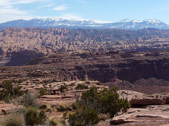
View of Behind the Rocks and the La Sal Mountains from the Amasa Back trail.
The Amasa Back trail offers a challenging, view packed hike to a ridge overlooking the Colorado River and the red rock country beyond.
See Trail Detail/Full Description
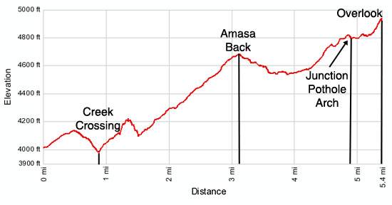
- Distance: 8.0 miles (round trip) to First Overlook
10.4 miles (round trip) to Colorado River Overlook - Elevation: 4,000-ft. at Trailhead
4,612-ft. at First Overlook
4,975-ft. at Colorado River Overlook - Elevation Gain: 612-ft. to First Overlook
975-ft. to Colorado River Overlook - Difficulty: moderate
- More Hikes in:
Moab / Southeast Utah
Why Hike Amasa Back
Fabulous views abound on this great hike climbing a 4WD road to a high isolated mesa surrounded on three sides by the Colorado River. As an added bonus two side trips along the trail lead to interesting rock art panels.
Initial views encompass the sculpted sandstone formations atop the walls rimming Kane Creek Canyon. As the route gain altitude views open south/southeast to Behind the Rocks, a maze of sandstone fins and knobs, and beyond to the La Sal Mountains. Atop Amasa Back the trail travels along a cliff edge, high above Jackson Hole, an abandoned meander on the Colorado, before climbing to a spectacular viewpoint overlooking the Colorado River.
While I am not typically a big fan of hikes along 4WD roads I make an exception for the Amasa Back trail. The big slickrock ledges and challenging obstacles along the road limit the number of 4-wheelers that attempt the route. Mountain bikers now have their own trail up Amasa Back, called Hymasa, which bypasses much of the jeep road.
My advice is to hike the road on a weekday when 4WD traffic is lightest. Avoid holiday weekends and the Jeep Rally. I only saw two jeeps on my last trip up the trail. Their presence did not detract from the hike. Watching them climbing the big ledges was actually quite entertaining.
Be forewarned that there is little shade along the route. The trail is best hiked in the spring or fall when temperatures are moderate. Be sure to carry plenty of water. Do not depend on finding water along the route.
Elevation Profile
Trail Resources
Trail Detail/Full Description / Trail Photo Gallery / Trail Map
Basecamp(s) Information:
Moab
Region Information:
Southeast Utah
Other Hiking Regions in:
Utah