Details: Dead Horse State Park Loop Trails 
Distance: 2.0 - 6.6 miles (loop)
Dead Horse State Park, near Moab in Southeast Utah
Hike Facts
- Distance: 2.0 - 6.6 miles (loop)
- Elevation: 5,940-ft. - 6,010-ft.
- Elevation Gain: 70-ft.
- Difficulty: easy-moderate
- Trail Highlights: See Trail Intro
- Basecamp(s): Moab
- Region: Southeast Utah
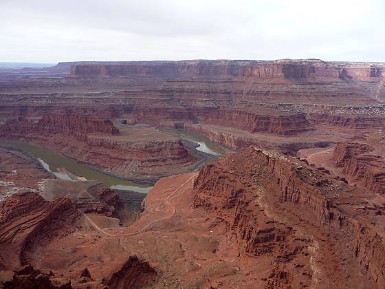
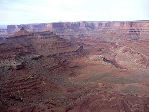
Amazing vistas of the sculpted canyons, pinnacles and buttes defining the landscape along the Colorado River and nearby Canyonlands National Park are the highlights of this easy 6.0 mile loop hike traveling around the southern end of Dead Horse State Park.
Dead Horse State Park Loop
This hike combines the West Rim and the East Rim trails to form a great loop hike around the south end of Dead Horse State Park plateau. If starting the hike early in the morning I suggest walking in a counter-clockwise direction from the west rim to the east rim so you are not looking directly into the rising sun. Otherwise the hike is great in either direction.
The trail starts at the Dead Horse State Park Visitor. Before beginning the hike take a few minutes to visit the viewpoint to the east of the Visitor Center building. The overlook offers good views of the geologic strata of the plateau’s walls composed of layers of Entrada, Navajo and Wingate Sandstone in addition to the Chinle, Moenkopi and Cutler formations. To the east are distant views of the La Sal Mountains while to the southeast you can see a small section of the Colorado River.
In the mid-distance to the east are large rectangular bodies of water. These are the solar evaporation ponds for the Potash Plant owned by Texasgulf Inc, located along the west side of the Colorado River. Potash is used in fertilizer.
The plant employs natural evaporation as part of its production process. The process works by pumping water from the Colorado River into an underground mine. The water dissolves the potash ore creating a brine that is pumped to the surface and into the ponds. The hot, dry climate rapidly evaporates the water leaving potash solids, which are then processed in a nearby plant. The 23 ponds covering 400 acres produce 260,000-lbs of potash/year.
After taking in the view to the east head around the back of the Visitor Center and find a trail heading southwest toward the campground and the West Rim trail. The trail crosses UT 313 in 0.3 miles and then follows a slightly descending traverse west on a packed sand trail through high desert scrub scattered with pinion pines and junipers. Initially the trail parallels the south side of the road leading to the campground. Just beyond the campground a trail to the right (north) at 0.6 miles leads to the Bighorn Overlook, a 2.5 miles round trip hike. (See below for more information.) We continue straight ahead on the West Rim trail.
At 0.9 mile reach the junction with the spur trail to the Rim Overlook. This 0.5 miles round trip detour is worth the minor effort. Turn west on the spur trail and follow the cairned path as it drops on easy grades to an outcropping with views to the west / southwest of the sheer red rock walls defining the East Fork Shafer Canyon drainage. Beyond is the Island in the Sky mesa.
Retrace your steps to the main trail and follow the boot beaten path as it heads south. Although you are not walking right along the rim the open landscape offers intermittent views to the west.
After hiking a little over 0.7 miles from the Rim Overlook junction reach the spur trail to Shafer Overlook, another recommended side trip. At the junction be sure to look southwest to see a small section of the Colorado River. The mountains rising beyond the high mesas to the south are the Abajo’s, located to the south/southeast of the Needles District of Canyonlands National Park.
The 0.4 miles round-trip spur to Shafer Point heads west to an overlook with great views of the East Fork and Middle Fork of Shafer Canyon. Bird’s Eye Butte and Crow’s Head Spire top the ridge separating the two canyons. Look south / southwest to see a small section of the Colorado River. After enjoying the views return to the main trail.
The West Rim trail now heads south for a short distance and then curves to the southeast. About 0.2 miles along the trail is a spot where you can walk over to the rim to see the first views of a large gooseneck about 2,000-ft. below the plateau, where the Colorado River take a 180-degree turn.
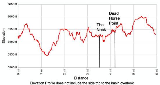
Soon the trail turns back to the south and crosses the “neck”, a narrow strip of land about 30-yards wide connecting the main part of the plateau to the point. (The neck is 0.8 miles from the junction with the trail to Shafer Point.)
According to one legend cowboys rounded up horses and herded them across the narrow neck of land to the point at the end of the plateau. The point was then converted into a natural corral by spreading branches and brush across the neck. During one roundup the cowboys left the horses they did not want corralled on the waterless point where the horses died of thirst, hence the unappealing name for the park.
Beyond the neck the trail travels south along the western rim of the point, with ever improving views of the gooseneck on the Colorado River. About 0.4 miles past the neck the trail curves to the southeast and follows a circuitous route to Dead Horse Point Overlook, reach at 4.2 miles from the trailhead (including side trips). From the point enjoy wonderful views of the gooseneck, the Colorado River, Pyramid Butte and the huge expanse of red rock canyons and mesas and buttes to the south. Facilities at the point include restrooms and picnic tables.
After taking in the views continue along the trail that rounds the point and starts heading north on the East Rim trail. Overlooks along the trail offer good views to the east / southeast of Pyramid Butte, the evaporation ponds and the La Sal Mountains. In several spots the geologic strata of the plateaus walls is on vivid display.
Cross back over the neck at 4.8 miles and follow the trail as it curves to the northeast, arriving at Basin Overlook at 5.4 miles. The 0.5 miles round trip spur trail heads east to the viewpoint that features expansive views of Shafer Basin, the evaporation ponds and Pyramid Point. Return to the main trail and walk the remaining 0.7 miles back to the visitor center.
Bighorn Over Look Trail – The 2.5 mile round trip Bighorn Overlook trail starts at a signed junction along the West Rim trail, 0.6 miles from the visitor center. From the West Rim trail turn right and follow the path as it travels north / northwest to a rocky point jutting into the East Fork of Shafer Canyon. Large potholes are scattered about the overlook that enjoys excellent views of Crows Head Spires, Bird’s Eye Butte and the Island in the Sky district of Canyonlands National Park.
Colorado River Overlook – Starting from the north end of the visitor center parking area, this 1.0 mile round trip hike heads north / northeast along the east rim of the plateau past desert potholes to a grand overlook of the Colorado River.
Elevation Profile
Driving Directions
From Moab: Head north on US 191 N for 11 miles and turn left (west) on UT 313. Follow UT 313 for 14.6 miles to an intersection. Turn left and drive on UT 313 for 6.5 miles to the park Visitor Center. (Continuing straight ahead at the intersection leads to Canyonlands National Park, Island in the Sky district.)
Trail Resources
Trail Intro / Trail Photo Gallery / Trail Map
Basecamp(s) Information:
Moab
Region Information:
Southeast Utah
Other Hiking Regions in:
Utah