Details: South Leigh to Granite Basin 
Distance: 7.2 - 15.6 miles (round trip)
Jedediah Smith Wilderness, Targhee National Forest, near Driggs in The Tetons
Hike Facts
- Distance: 7.2 - 15.6 miles (round trip)
- Elevation: 7,090-ft. - 9,530-ft.
- Elevation Gain: 1,385-ft. - 2,440-ft.
- Difficulty: moderate-strenuous
- Trail Highlights: See Trail Intro
- Basecamp(s): Driggs / Jackson Hole
- Region: The Tetons
Lovely forests and meadows filled with wildflowers along with views of peaks rimming South Leigh Canyon, Fred’s Mountain and the summit of the Grand Teton, are the rewards of this hike up a pretty canyon. Parties looking for an easier hike can turn around at the meadows, located at 3.6 miles.
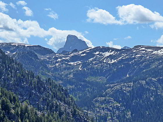
South Leigh Canyon

Note: The mileage in this description begins at the parking area adjacent to the turnaround at the end of the road. (See driving directions below.)
The trail starts near a large trail sign along the east side of the turnaround at the end of the South Leigh Canyon Road. Initially the path follows a two track that soon turns into a trail. The trail ascends on gentle grades along the north side of the Leigh Canyon, traveling through meadows and forest. During the mid- to late-July the meadows are filled with wildflowers.
In just under 0.5 miles the path passes a junction with the Beaver Creek Trail branching left (north). A short distance beyond the trail crosses the first of numerous tributary streams feeding into South Leigh Creek. South Leigh Creek, located to the south of the trail, is hidden from view by the lush foliage. Simple log bridges are provided for the wider crossings. Hop over the smaller streams or use well placed rocks to keep your feet dry. Later in the season many of these streams will either diminish to a trickle or dry up. The bulk of the streams are crossed during the first mile of the walk.
At 1.4 miles reach the boundary of the Jedediah Smith Wilderness and the junction with the Andy Stone Trail, heading left (northeast). This is a longer, more strenuous and, in my opinion, less scenic option for reaching Granite Basin. We continue up the South Leigh Trail, crossing three more tributary creeks on logs or rocks.
At 2.4 miles views open to South Leigh Creek flowing down the canyon floor. The trail briefly travels alongside the lake before again moving away from the shore. Thick trees growing along the creek keep the views to a minimum.
At 2.9 miles pass the junction with the Beards Wheatfield Trail, branching right (southeast). The junction is easy to miss.
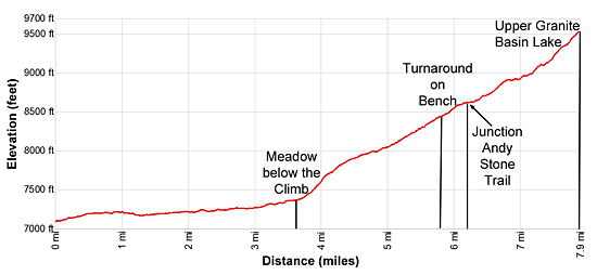
At 3.6 miles the trail breaks from the forest into a lush meadow filled with wildflowers. This meadow is a good turnaround point for parties looking for an easier hike. Beyond the meadow the trail starts ascending, gaining over 1,000-ft. in 1.7 miles.
To continue, look for a sign set amid the blooms pointing to the trail, which curves to the left (north) and starts climbing moderate to moderately-steep switchbacks through lush meadows and scattered trees up the canyon’s north slopes. As the path gain elevation the trees thin and sage starts making an appearance along the dryer slopes.
Views open to the cliffs rising above the trail to the north, the head of South Leigh Canyon to the east/southeast and Fred’s Mountain to the southwest. Soon the summit of the Grand Teton appears beyond the saddle on the ridge at the head of the canyon. As the trail climbs enjoy ever improving views of the Grand along with the peaks rimming the head of the valley.
At 4.7 and 4.9 miles the trail crosses a stream draining the slopes above the trail. Beyond the last switchback, at 5.4 miles, the trail reaches the edge of a large meadow-clad bench high above the north side of the canyon. The vast meadows are awash in lovely wildflowers and small groves of stunted conifers.
The trail now ascends northeast across the bench. The long southwest ridge of Peak 9974 towers above the bench to the northeast. At 5.8 miles large rocks set amid the meadows offer scenic perches with vistas stretching from Fred’s Mountain in the southwest to the head wall of South Leigh Canyon to the high ridge rimming the bench. The summit of the Grand Teton rises beyond the head of South Leigh Canyon to the southeast. This viewpoint is another good turnaround point for day hikers.
Continuing the hike to upper Granite Basin Lakes is beyond the range of most day hikers and best done as an overnight or two night backpack that includes a visit to the Green Lakes. From the viewpoint the trail continues across the bench to the junction with the Andy Stone trail at 6.25 miles. Bear right (east/northeast) at the junction to stay on the South Leigh Trail to Granite Basin Lakes.
The path now travels on moderate to moderately steep grades through forest and intermittent meadows set amid rock outcroppings and boulders. At 7.1 miles the trail curves to the right (south/southeast) and the ascent steepens. Cross a tributary creek at 7.25 miles and then outlet stream for upper Granite Basin Lake at 7.4 miles.
At 7.5 miles the trail curves to left (east), ascending tight switchbacks to the meadows above the south side of upper Granite Basin Lake at 7.8 miles. The two other lakes in the basin are located to the south/southeast of this lake.
Beyond the lake the trail curves to the left (north) as it ascends on moderate grades through rock outcroppings and low, rocky knolls to the a saddle on the divide, at 8.4 miles. The saddle separates Granite Basin Lakes and the Green Lakes. The path now descends gently across the broad saddle to an overlook above the Green Lakes at 8.8 miles. From the overlook the trail descends to the junction with the Teton Crest Trail and the loop trail around the Green Lakes at 9.4 miles. See the Green Lakes – Granite Basin Loop description for more information.
Elevation Profile
Driving Directions
From Driggs, ID: From the traffic light on Main St./ID-33 W drive north on ID-33 for 5.6 miles. As the road turns to the left (west) continue straight ahead, exiting the highway onto N 500 West. Take the first right (0.2 miles) on to W 5750 North Road. Follow the road for 0.5 miles and turn left onto N Baseline Road. The road soon curves to the right and becomes E 6000 N. Follow E 6000 N for 2.6 miles and then turn left on N Baseline Road. Continue on the road for 0.8 miles. The road now curves to the right and becomes South Leigh Canyon Road. Follow South Leigh for 3.1 miles to the trailhead at a traffic loop. This is the best parking area.
It is possible to follow a 2-track that heads east from the loop for 0.2 miles to a small parking area near a grove of conifers. The South Leigh Road is initially paved but soon turns to gravel/dirt. There are a few ruts and potholes along the way.
From Jackson, WY: Head south/southwest through Jackson on US 191 S / US 26 W. At the southwest end of town turn right on WY-22 W. (A large Albertson’s Supermarket is located on the southeast corner of the intersection.)
Follow WY-22 W/ID 33 W for 36.9 miles. (The route will cross Teton Pass and enter Idaho, where the road becomes ID-33 and passes through Victor and Driggs, ID.) As ID 33 W turns to the left (west) continue straight ahead, exiting the highway on to N 500 West. Take the first right (0.2 miles) on to W 5750 North Road. Follow the road for 0.5 miles and turn left onto N Baseline Road. The road soon curves to the right and becomes E 6000 N. Follow E 6000 N for 2.6 miles and then turn left on N Baseline Road. Continue on the road for 0.8 miles. The road now curves to the right and becomes South Leigh Canyon Road. Follow South Leigh for 3.1 miles to the trailhead at a traffic loop. This is the best parking area.
It is possible to follow a 2-track that heads east from the loop for 0.2 miles to a small parking area near a grove of conifers. The South Leigh Road is initially paved but soon turns to gravel/dirt. There are a few ruts and potholes along the way.
Trail Resources
Trail Intro / Trail Photo Gallery / Trail Map
Basecamp(s) Information:
Driggs / Jackson Hole
Region Information:
The Tetons
Other Hiking Regions in:
Wyoming