Details: Hermitage Point 
Distance: 9.9 miles (loop)
Grand Teton National Park, near Grand Teton NP in The Tetons
Hike Facts
- Distance: 9.9 miles (loop)
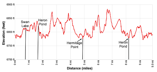
- Elevation: 6,790-ft. - 6,892-ft.
- Elevation Gain: 150-ft.
- Difficulty: easy
- Trail Highlights: See Trail Intro
- Basecamp(s): Grand Teton NP / Jackson Hole
- Region: The Tetons
Two scenic ponds, views of the Tetons towering above Jackson Lake, a chance to see wildlife and some solitude make the Hermitage Point Loop a good option for hikers looking for an easy, full day hike or a good hike when weather precludes hiking in the high country.
Hermitage Point Loop
From the parking area to the south of the Colter Bay Visitor Center (see driving directions below), walk south on the paved road toward the boat landing area. Here you will see a sign reading, “Foot Trail Only – No Road.” This is the start of the trail to Heron Pond, Swan Lake and Hermitage Point.
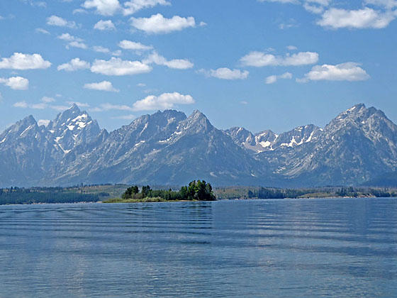
The mostly level trail follows the old service road that curves around the south side of the Colter Bay Marina. Soon views open to majestic Mount Moran (12,605-ft.) towering above the west side of Jackson Lake.
At a junction at 0.4 miles, bear left toward Swan Lake. The trail now heads southeast through meadows. At the next junction continue straight ahead toward Swan Lake. Soon the trail enters the trees and curves to the right (south), reaching the northwest shore of Swan Lake at 0.8 miles. Follow the trail as it travels through trees slightly to the west of the lake shore. Short spur trails lead to various points along the shore. Lily pads fill large portions of the lake. Keep an eye out for water fowl along with beavers and moose.
Reach the south end of the lake at 1.5 miles. Here the trail turns right (southwest), wandering through trees and small meadows to a junction near the east shore of Heron Pond at 1.7 miles. Turning right at the junction will lead back to Colter Bay. To the left is the Hermitage Point trail. Straight ahead a spur trail drops down to the lake shore.
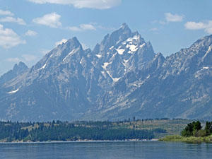
Take the spur trail dropping down the Heron Pond. Here Mount Moran and Bivouac Peak (10,825-ft.) form a lovely backdrop for Heron Lake and Half Moon Bay, visible beyond the pretty pond. Heron is another good place to look for waterfowl, otters and moose. On my last visit I watched an otter swimming between the shore and his den near the lakeshore.
Return to the junction after visiting the lake and head south on the trail toward Hermitage Point. The path now curves to the right (west) around the south shore of Heron Lake with good views across Heron Pond to Eagles Rest Peak (11,258-ft.) and Range Peak (11,355) rising above the west side of Jackson Lake.
At the southwest end of the pond the trail turns left (south) and travels through trees on gentle rolling terrain. Half Moon Bay lies to the west, unseen through the forest. Reach a junction at 2.6 miles. Bear right on the trail toward Hermitage Point. You are now at the northern end of the peninsula jutting out into Jackson Lake. The trail to Hermitage Point heads south and then southwest through the forest a good distance from the peninsula’s western shore. The thick forest blocks views of the high peaks.
At 4.0 miles the trail nears to western shore and the trees thin. Sagebrush flats now offer intermittent views of Mount Moran, Bivouac Peak and Eagles Rest Peak. Soon you can see distant views of Teewinot Mountain (12,325-ft.), Grand Teton (13,370-ft.), Rockchuck Peak (11,144-ft.) and Mount St. John (11,430-ft.) to the southwest.
At 4.3 miles the trail breaks from the trees and crosses sagebrush flats. As you near the end of the peninsula and Hermitage Point the views continue to expand and improve.
Reach the junction with the spur trail dropping down to Hermitage Point at 4.8 miles. A short descent leads to the shore along at the end of the peninsula. Here panoramic views stretch across Jackson Lake from the Bivouac Peak to Teewinot Peak and Grand Teton in the southwest. From this perspective views extend up the length of Paintbrush Divide to Peak 11,270, McClintock Peak and Buckinham Palace rising above the head of the canyon. Rockchuck Peak and Mount Woodring rand Rockchuck Peak guard the entrance to the canyon.
To the west are fine views of Mount Moran and Bivouac Peak rising above the entrance to Moran Canyon. The large island to the west of Hermitage point is Elk Island while Donoho Point lies to the east. To the northwest look across Elk Island for views of Eagles Rest, Ranger Peak and a host of unnamed summits towering above Waterfall Canyon.
It’s hard to pull yourself away from this stunning viewpoint, but you still have miles to walk on the return leg of the loop. Return to the Hermitage Point junction and turn right (northeast) on the trail along the east side of the peninsula. The trail initially travels through sage flats with scattered trees with distant views of the peaks rising to the east of Moran Junction.
At 5.0 miles the trail reenters the trees and curves to the right (northeast), staying near the shore. Along the way pass a backcountry campsite. The trail starts moving away from the shore at 5.75 miles. Two large open meadows offer distant views of Signal Mountain to the east.
At 7.0 miles reach a junction. The trail straight ahead is 0.2 miles longer and avoids backtracking. It passes several oxbows along Third Creek and a swampy area choked with willows. I’ve seen some moose along this section of the trail. At 7.8 miles turn left at a junction and reach the southeast end of the Heron Pond and a junction at 8.4 miles.
Alternatively, turn left at the junction on a trail that crosses the top of the peninsula. At 7.4 miles turn right on the trail toward Colter Bay and Heron Pond, reaching the southeast end of the lovely pond and a junction at 8.2 miles.
Bear left (northwest) at the four-way junction at Heron Pond, following the trail along the pond’s eastern shore. Along the way enjoy more nice views of the high peaks to the west.
Pass a junction branching left at 8.6 (8.8) miles. Continue straight ahead toward Colter Bay. Reach the south end of Colter Bay and a junction at 9.1 (9.3) miles. Continue straight ahead on the trail that heads north along the shore toward Colter Bay. Stay on the trail along the bay at the next intersection at 9.3 (9.5) miles and return to the trailhead at 9.7 (9.9) miles.
Elevation Profile
Driving Directions
From Jackson Hole, WY: From the main square at North Cache and Broadway in Jackson Hole, WY, head north on North Cache Street (US-191 N / US-26 E) for 30.2 miles to the junction with US Highway 26. Turn left to stay on US 191-N (US-287 / US-89). Go through the Grand Teton National Park Entrance station in 0.2 miles and then continue straight ahead for 9.3 miles to the junction with Colter Bay Village.
Turn left onto the Colter Bay Village Road and follow the road for 0.9 miles to end of the road and a “T” intersection. The Colter Bay Visitor Center is to the right. We turn left onto Colter Bay Marina Road and park as close as possible to the south end of the road. Walk south from the parking area, following the paved road that leads down towards the boat landing area. Here you will see a "Foot Trail Only - No Road." This marks trailhead for the Heron Pond, Swan Lake and for the Hermitage Point trail.
From Teton Village, WY: Head out of the village and turn left on the Moose-Wilson Road. Follow the road for 1.1 miles to the park entrance/fee station. Beyond the fee station drive 6.9 miles on the narrow, winding road and turn right on Teton Park Road. Follow Teton Park Road for 0.7 miles and then turn left on US 191 N (US 287 N / US 89). Drive for 17.8 miles to the junction with US Highway 26. Turn left to stay on US 191-N (US-287 / US-89). Go through the Grand Teton National Park Entrance station in 0.2 miles and then continue straight ahead for 9.3 miles to the junction with Colter Bay Village.
Turn left onto the Colter Bay Village Road and follow the road for 0.9 miles to end of the road and a “T” intersection. The Colter Bay Visitor Center is to the right. We turn left onto Colter Bay Marina Road and park as close as possible to the south end of the road. Walk south from the parking area, following the paved road that leads down towards the boat landing area. Here you will see a "Foot Trail Only - No Road." This marks trailhead for the Heron Pond, Swan Lake and for the Hermitage Point trail.
Trail Resources
Trail Intro / Trail Photo Gallery / Trail Map
Basecamp(s) Information:
Grand Teton NP / Jackson Hole
Region Information:
The Tetons
Other Hiking Regions in:
Wyoming