Details: Phelps Loop 
Distance: 3.3 - 7.2 miles (loop)
Grand Teton National Park, near Grand Teton NP in The Tetons
Hike Facts
- Distance: 3.3 - 7.2 miles (loop)
- Elevation: 6,400-ft. - 6,820-ft.
- Elevation Gain: 420-ft.
- Difficulty: easy-moderate
- Trail Highlights: See Trail Intro
- Basecamp(s): Grand Teton NP / Jackson Hole
- Region: The Tetons
Hike through sagebrush flats, forest and meadows to scenic Phelps Lake, nestled in a glacial bowl beneath Prospector Mountain, Albright Peak and Static Divide Peak. Tailor the length of the hike to match the available time and the ability of your party.
Phelps Lake Loop
The trail to Phelps Lake starts from the parking lot for the Laurance S. Rockefeller Preserve off Moose-Wilson Road. (See driving directions below.) The trail heads west across sagebrush flats with fine views of Teewinot Mountain (12,235-ft.), Grand Teton (13,770-ft), Middle Teton (12,804-ft.), South Teton (12,514-ft.), Buck Mountain (11,938-ft.), Static Peak (11,303-ft.) and Albright Peak (10,552-ft.)to the west/northwest. At 0.2 miles reach the Visitor Center, housed in an interesting building with exhibits about the preserve.
Beyond the visitor center a broad path enters the trees and soon reaches a short spur trail to an overlook along the west side of Lake Creek, a pristine stream emanating from Phelps Lake. After visiting the overlook, continue straight ahead to a junction and beginning of the loop at 0.3 miles. At the junction the Lake Creek Trail branches left while the Woodland Trail continues straight ahead. Either direction will work.
To follow this description turn left on the Lake Creek trail and immediately cross Lake Creek on a good wood bridge. The trail ascends on easy grades, generally heading west/southwest through a spruce-fir-pine forest to a crossing of the Moose Wilson Road at 0.7 miles. Use caution when crossing the road. Dense vegetation makes it difficult for drivers on the narrow, twisting road to see hikers emerging from the woods.
Beyond the road the trail heads northwest through the forest. At 0.8 miles pass a junction with the Aspen Ridge trail branching left. The Boulder Ridge Trail, to the right, drops down to and crosses the creek on a bridge and later connects with the Woodland Trail. Continue straight ahead on the Lake Creek Trail, ascending on easy grades through trees to the west of the creek. Openings along the trail offer views of the creek. A large meadow at 1.2 miles features nice vistas of Prospector Mountain (11,241-ft.) and Albright Peak.
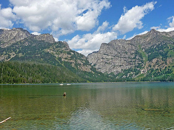
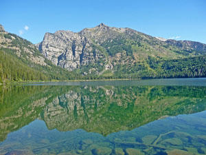
At 1.6 miles reach a junction. The trail to the right leads to bathrooms. Continue straight ahead on the Lake Trail to the junction with the Phelps Lake trail circling the lake at 1.7 miles. To the right (east) the Phelps Lake trail heads toward the Woodland Trail. To the left (west) it heads toward Huckleberry Point. Straight ahead a short spur trail dropping down to a viewpoint along the lake’s south shore. Here Prospector Mountain, Albright Peak and Static Peak serve as the backdrop for beautiful Phelps Lake, the sixth largest lake in the park. Rugged cliffs along Albright’s southern flanks mark the entrance to Death Canyon.
Return to the Phelps Lake trail, which circles the lake, after enjoying the view from the shore. Parties looking for a shorter hike will want to explore the area around the lake’s south shore and then return to the parking area via the Woodland Trail. To complete the shorter hike take the Phelps Lake trail east toward the Woodland trail. This trail leads to additional viewpoints along the shore and then curves around a small bay, crossing a bridge over the lake’s outlet. Beyond the crossing are additional viewpoints near the Woodland Trail junction. Return via the Woodland Trail (1.3 miles) for a 3.3 mile loop. (See the description below for detailed information on the Woodland Trail.)
To hike around the lake return to the junction and turn west toward Huckleberry Point. You can hike either way around the lake. This description describes walking the trail in the clock-wise direction around Phelps Lake.
Almost immediately pass the junction with the other end of the Aspen Ridge trail branching left and then traverse a boardwalk over a swampy area near a small pond. Beyond the boardwalk the path curves to the right (northwest) along the lake’s western shore. Openings in the trees provide fine views of the high peaks towering above the north side of the lake.
At 2.2 miles reach the junction with the spur trail branching right to Huckleberry Point. The 0.2 mile round-trip detour leads to a rock point at the end of a peninsula jutting into Phelps Lake. Here we have more fine views of Phelps Lake, the entrance to Death Canyon, Albright Peak and Static Peak. This is another potential turnaround point for parties looking for a shorter hike.
Beyond Huckleberry Point the trail travels through forest along the lake’s western shore. Openings in the trees offer more nice views of the lake. At the head of the lake the path briefly climbs the slopes below Prospector Mountain to bypass a marshy area along the lake’s inlet stream. On the ascent the trail passes a junction with the Valley trail. Stay right at the intersection. The Phelps Lake Trail and the Valley trail now share the same path for the next 0.4 miles.
Past the junction the trail reaches the high point on the loop around the lake and then curves to the northeast high above the lake’s north shore. The brushy slopes along the trail are filled with wildflowers in season. A short steep drop soon moderates as the trail crosses Death Canyon Creek, which runs into Phelps Lake, at 3.6 miles.
At 3.7 miles pass the junction with the Valley Trail branching left (north) to meet the Death Canyon Trail. Stay right to continue on the Phelps Lake Trail toward the east side of the lake. Soon the trail curves to the right (southeast) and drops down to a sandy beach at the northeast end of the lake at 4.0 miles. The beach is a great place to relax and take a break.
The trail now traverses through trees above the eastern shore of Phelps Lake, passing three backcountry campsites and then a massive boulder along the lakeshore at 4.4 miles. The boulder is a favorite spot for locals. Here there is a nice area for hanging out around the lake shore. Children use the boulder as a spring board for jumping into the lake.
As you proceed toward the foot of the lake openings offer fine views across the lake to Prospector Mountain. Mount Hunt rises above Open Canyon. Soon Peak 10,905 at the head of Open Canyon joins the scene.
Near the foot of the lake, at 5.5 miles, the Boulder Ridge trail branches to the left. We continue straight ahead on the Phelps Lake Trail.
A short spur trail leads to a lovely viewpoint at the foot of the lake at 5.6 miles. Here views extend across the lake to Prospector Mountain and Albright Peak flanking the entrance to Death Canyon. Static Peak towers above Albright to the north. Spur trails around this area and the area across the small bay at the foot of the lake mark the sites of former JY Ranch buildings. The buildings were removed and projects restored the natural area around the lakeshore.
When you are done soaking in the views, return to the main trail. In a short distance reach the junction with the Woodland Trail, branching left. Take the Woodland trail, heading south, back toward the Visitor Center. Soon the trail curves to the southeast and passes the junction with the other end of the Boulder Ridge trail at 6.0 miles.
Beyond the junction the trail descends on moderate grades to the road at 6.3 miles. Carefully cross the road and then follow the trail back to the Visitor Center at 6.7 miles. On a hot day the Visitor Center offers a nice place to cool off before walking across the sagebrush flats and back to the parking lot at 6.9 miles.
Note: There is a 0.3 mile segment of trail along the south shore of Phelps Lake between the Lake Creek and Woodland Trail. This area is well worth exploring.
The Woodland trail offers the shortest access to Phelps Lake, 1.3 miles, compared to the Lake Creek Trail, which is 1.7 miles from the parking area.
Hikes can be extended by incorporating portions of the Aspen Ridge trail (2.5 miles one-way), which climbs to a high ridge with views of the peaks to the west, and Boulder Ridge trail (1.7 miles one-way), with views of Jackson Hole to the east.
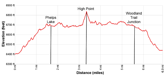
Elevation Profile
Driving Directions
From Jackson, WY: From the main square at North Cache and Broadway, head north on North Cache Street (US-191 N / US-26 E) for 12.4 miles to Moose Junction and turn left on Teton Park Road. Follow Teton Park Road for 0.7 mile and turn left on the Moose-Wilson Road. Follow the narrow, winding road for 3.7 miles and turn left on the signed road leading to the Laurence S. Rockefeller Preserve. Drive 0.4 miles on the preserve road to the parking area. The preserve is very popular and the parking lot fills early in the day during the summer. Note that a portion of the Moose-Wilson road is unpaved and very rough.
From Teton Village, WY: Head out of the village and turn left on the Moose-Wilson Road. Follow the road for 1.1 miles to the park entrance/fee station. Beyond the fee station drive 3.2 miles on the narrow, winding road and turn right on the signed road leading to the Laurence S. Rockefeller Preserve. Drive 0.4 miles on the preserve road to the parking area. The preserve is very popular and the parking lot fills early in the day during the summer. Note that a portion of the Moose-Wilson road is unpaved and very rough.
Trail Resources
Trail Intro / Trail Photo Gallery / Trail Map
Basecamp(s) Information:
Grand Teton NP / Jackson Hole
Region Information:
The Tetons
Other Hiking Regions in:
Wyoming