Backpack: Big Sandy to Elkhart Park via Fremont and Highline Trails
Segment 5: Valley Lake Junction to North Fork Lake
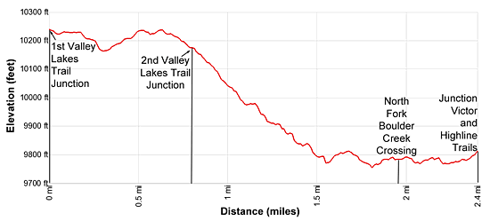
Distance: 2.4 miles (one way)
Bridger Wilderness, Bridger-Teton National Forest, near Big Sandy in Wyoming's Wind River Range
By: Diane Greer
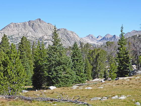
North Fork Peak and the summits along North Fork Canyon
- Distance: 2.4 miles
- Elevation: 10,210-ft. at Junction Valley Lakes
10,245-ft. at High point on the trail
9,770-ft. at North Fork Boulder Creek Crossing
9,785-ft. at Junction Hay Pass / Highline Trail - Difficulty: moderate
- Basecamp: Big Sandy / Elkhart Park
- Region: Wyoming's Wind River Range
Valley Lake Junction to North Fork Lake Description
To the west of the second Pipestone Lake the Fremont trail reaches an unmarked junction. Here the trail to Valley Lakes and Europe Canyon branches right (north). We bear left (northwest) on the Fremont trail toward North Fork Lake.
Beyond the junction the Fremont trail travels through meadows set amid rock outcroppings, clusters of trees and dead snags, the reminders of the 1988 Fayette Fire. At 0.6 miles the trail reaches a high point (10,245-ft.) of this section of the trail and views open to North Fork Peak (11,175-ft.) and the summits towering above the North Fork Canyon to the north/northwest.
Reach the junction with the second trail to Valley Lakes, branching to the right (northeast), at 0.8 miles. We continue heading northwest, descending through trees and meadows to a creek crossing at 1.25 miles.
Past the crossing the trail continues its descent through trees to a small meadow at 1.5 miles and then travels along an undulating course through trees interspersed with meadows. To the south views open to North Fork Lake.
Reach the North Fork Boulder Creek at 1.8 miles. This segment of the stream links Lake Victor to the north with North Fork Lake, now visible to the south. You’ll need to take off your boots and wade across the creek, which varies from knee- to shin-deep depending on the season and time of year.
Beyond the crossing the trail turns to the left (southwest) as it meanders through meadows and rock outcroppings along the north side of North Fork Lake (9,754-ft.) to a signed junction at 2.3 miles. The unmarked trail to the left (southwest) skirts the lake’s west shore and then climbs an inlet stream to the Highline trail. We continue straight ahead (west/northwest) on the Fremont trail, signed for Hat Pass.
Arrive at a signed four-way junction at 2.4 miles. The Hay Pass trail branches to the right (north) toward Lake Victor and Hay Pass. To the left (south) is the Highline trail to Lake Vera. Straight ahead (northwest) is the north-bound Fremont trail to Hat Pass and August Lake.
North Fork Lake lies nestled in a shallow bowl surrounded by forested granite knobs on three sides. Unfortunately the 1988 Fayette Fire burned large areas of the forest to the south of the lake. Today large patches of dead trees still stands on the rocky knobs rimming the southern and eastern lakeshores.
If you are looking to camp around North Fork Lake, don’t cross the North Fork of Boulder Creek. Instead, head downstream (south) along the creek. Soon the creek swings to the west. Continue heading south and start searching for a good site along the lake’s eastern shore. For more scenic sites, take a one mile (one-way) detour on the Hay Pass trail to Lake Victor. There are numerous sites along Victor’s northwestern shore. Note: North Fork Lake and Lake Victor are popular with fishermen and frequented by large stock parties.
Return to Segment 4: Sandpoint Lake to Valley Lake Junction
Go To Segment 6: North Fork Lake to Bell Lakes Junction
Elevation Profile
Backpack Segments
- Introduction: Big Sandy to Elkhart Park via Fremont and Highline Trails
- Segment 1: Big Sandy to Marms Lake
- Segment 2: Marms Lake to Raid Lake
- --- Side Trip: Bonneville Lakes
- Segment 3: Raid Lake to Middle Fork Junction above Sandpoint Lake
- --- Side Trip: Middle Fork Lake Trail
- --- Side Trip: Middle Fork Lake via the Rainbow Lake Trail
- --- Side Trip: Photo Pass Trail
- Segment 4: Sandpoint Lake to Valley Lake Junction
- --- Side Trip: Europe Canyon and Pass
- Segment 5: Valley Lake Junction to North Fork Lake
- --- Side Trip: Hay Pass, the Golden Lakes and Fall Creek Pass
- Segment 6: North Fork Lake to Bell Lakes Junction
- Segment 7: Bell Lakes Junction to Pole Creek
- --- Side Trip: Cook and Wall Lakes
- Segment 8: Pole Creek to Little Seneca Lake
- Segment 9: Little Seneca Lake to Island Lake
- --- Side Trip: Titcomb Basin
- --- Side Trip: Indian Basin and Pass
- --- Side Trip: Island Lake Waterfall Hike
- Segment 10: Island Lake to Elkhart Park
Driving Directions to Big Sandy Trailhead
Big Sandy Trailhead: This popular trailhead is located in the southern Wind River Range next to the Big Sandy River.
Directions from Pinedale: From the intersection of Pine Street (US 191) and North Tyler Ave (the Pinedale Tourism office is located on the northeast corner) in Pinedale, WY, drive south on Highway 191 for 11.7 miles and then turn left (east) on WY-353. After 15.5 miles you will notice signs referring to the road as the Big Sandy-Elkhorn Road and after 18 miles the paved road will change to a good packed dirt/gravel surface.
Shortly after the pavement ends go straight through a junction, and drive south crossing the Big Sandy River (Buckskin Crossing). Follow the road for a total of 27.3 miles. Shortly after crossing the Big Sandy River you will reach a junction with the Lander Cutoff Road (the next junction). Turn left on the Lander Cutoff Road. There is a wood sign at the intersection pointing toward the Big Sandy trailhead.
Drive 7.0 miles on the Lander Cutoff Road and then turn left on the Big Sandy Opening Road. Here you will see a sign for the Big Sandy Campground and trailhead. The road now deteriorates and narrows. Blind corners and lush foliage along the road make it hard to see ahead. Drive carefully, following the rocky, rutted road for 9.8 miles to a "Y" intersection. Bear right at the intersection to continue along the Big Sandy Opening Road (Forest Service Road 850). (The road branching to the left leads to the Big Sandy Lodge and Mud Lake.) Follow the road for 0.8 miles to the trailhead parking area, equipped with an outhouse.
Allow an hour and a half to reach the trailhead from Pinedale. The parking area is too small for the number of backpackers visiting the area during the height of the summer. If the parking area is full, find a safe place to park off the access road.
I recommend a high clearance vehicle to reach the trailhead. Passenger cars can make it OK if driven carefully. Check at the Pinedale ranger station before starting your trip to learn about current road and trail conditions. The Ranger Station is located to the east of the Ridleys Grocery Store on US 191 (Pine Street in Pinedale). The entrance to the ranger station is on the Fremont Lake Road. (You can also reach the parking area for the ranger station by driving east through the Ridley’s parking lot.)
This trailhead is remote, so be sure to have a full tank of gas. The dirt road become slippery when wet. The campground at the parking area is tiny, with only 4 sites. I would not plan on camping at the trailhead before starting your backpack.
Elkhart Park Trailhead: From the intersection of Pine Street (US 191) and North Tyler Ave (the Pinedale Tourism office is located on the northeast corner) in Pinedale, WY, drive east on Highway 191 (East Pine Street) for 0.3 miles and bear left onto Fremont Lake Road. Follow this road for 14.3 miles and turn right into the large parking area for the Elkhart Park/Pole Creek Trailhead. After the first 3.0 miles the road will turn into Skyline Drive/Forest Service Road 370740. The trailhead is located at the northeast end of the parking lot between the outhouse and the trailhead kiosk. It should take about 25 minutes to drive the trailhead. The last section of the road has some holes and uneven spots.
Trail Resources
- Backpack Intro
- Segment Photo Gallery
- Segment Map
- Trailhead(s) Information: Big Sandy / Elkhart Park
- Region Information: Wyoming's Wind River Range
- Other Hiking Regions in: Wyoming