Backpack: Texas Pass - Cirque of the Towers - Jackass Pass Loop
Segment 3: Shadow Lake over Texas Pass to the Cirque of the T
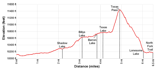
Distance: 2.3 - 6.4 miles (one way)
Bridger Wilderness, Bridger-Teton National Forest, near Big Sandy in Wyoming's Wind River Range
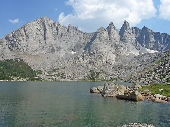
Shadow Lake
- Distance: 2.3 - 6.4 miles
- Elevation: 0.0 miles to Junction of Shadow Lake and the Pyramid Creek trails (10,160-ft.)
2.3 miles to Shadow Lake (10,287-ft.)
3.1 miles to Billys Lake (10,616-ft.)
3.8 miles to Barren Lake (10,712-ft.)
4.2 miles to Texas Lake (10,770-ft)
4.9 miles to Texas Pass (11,447-ft.) (off-trail route)
6.0 miles to Lonesome Lake (10,166-ft.) (off-trail route)
6.5 miles to Junction North Fork trail at Lonesome Lake (10,166-ft.)
(Note: mileage will vary since this trail follows off-trail routes) - Difficulty: moderate
- Basecamp: Big Sandy
- Region: Wyoming's Wind River Range
Shadow Lake over Texas Pass to the Cirque of the T Description
Shadow Lake is a great destination for a short backpack out of Big Sandy, a scenic side trip on a longer backpack or a route into the Cirque of the Towers via Texas Pass.
The Shadow Lake Trail is located along the Pyramid Lake Trail, a short distance to the south of Washakie Creek. There are two places to pick-up the trail:
-
-
- Heading north on the Pyramid Lake trail from Marms Lake, the junction with Shadow Lake, branching right (east/northeast) is located at 1.6 miles. From the junction the Shadow Lake trail descends on easy grades to the southern shore of Washakie Creek. -
- Heading south on the Pyramid Lake trail from Skull Lake, descend to and cross Washakie Creek. On the south side of the creek is a junction with the Shadow Lake Trail at 1.25 miles. Turn left on the Shadow Lake Trail and follow the path as it heads southeast along the south shore of Washakie Creek. The trail fades as it crosses a marshy area. Soon you will see a trail descending from a bench to the south. Aim for this trail. This is the main trail to Shadow Lake.
The two trails meet at 0.2 miles. The trail now heads up the valley on easy grades through meadows, paralleling the creek. Mount Washakie (12,524-ft.) and Big Chief Mountain (12,335-ft.) rim the valley to the north while Easy Day Peak (11,660-ft.) rises to the south.
As you ascend the valley views open to the backside of the Cirque of the Towers including Bollinger Peak (12,232-ft.), Wolfs Head (12,163-ft.), Overhanging Tower (12,164-ft.), Sharks Nose (12,229-ft.) and Block Tower (12,210-ft.). The summits of Camels Hump (12,533-ft.) and Lizard Head Peak (12,842-ft.) rise above the cirque to the northeast.
At 1.1 miles the trail crosses Washakie Creek. Late in the season you can rock-hop across the creek. Early in the season or during periods of high water you may need to take off your boots and wade. Beyond the crossing the trail continues heading east through meadows sprinkled with willow thickets to the north of the creek.
At 1.6 miles the trail crosses a side stream and soon starts a moderate climb through spruce-pine forest to the bench cradling Shadow Lake. Atop the bench the trail turns right (southeast) at 2.0 miles and travels through willow thickets and trees. As the trail nears Washakie Creek, the outlet stream for Shadow Lake, the path wanders through a marshy area and crosses a small side stream. Beyond this point it is a short distance to the northwest shore of Shadow Lake (10,287-ft.) at 2.3 miles. The jagged peaks and spires of the 12,000-ft. peaks along the backside of the Cirque of the Towers form a stunning backdrop for this beautiful lake.
Good campsites can be found in the forested slopes along the north side of the lake. Across the outlet stream are a few additional sites in the trees at the southwest end of the lake. More camping is available around Billy’s Lake further up the basin.
Shadow Lake to Texas Lake
From the northwest end of Shadow Lake there are two routes that lead to Billys Lake and Texas Lake in the upper basin. One trail travels along Shadow Lake’s northern shore and the climbs along Billys Lake’s outlet stream. The second route climbs the forested slopes to the north of the lake, skirting the base of Blair Peak’s southwest ridge. The two trails are about the same length and meet in the meadows along the east side of Billys Lake. In my opinion, the route along the north shore is the easiest to follow.
Around Shadow Lake’s outlet stream a maze of trails lead to camping areas making it difficult to find the start of the hike to Billys Lake and beyond. To head toward Texas Lake, from the outlet stream walk east and then southeast on the path along Shadow Lake’s north shore. The trail travels through willow-choked meadows and then climbs into the forest above the lakeshore.
Soon you will pass through campsites with large fire pits and see use trails heading north from the lake. Continue heading southeast, staying on the trail traversing above the lake’s north shore.
After a quarter mile the route curves to the left (east) and starts climbing on moderate grades away from the lake to avoid a boulder field along the shore. Openings in the trees offer intermittent views of the jagged peaks rising to the north of Shadow Lake. Keep an eye out for rock cairns marking the trail.
At 2.75 miles the trail skirts the west side of a large rock outcropping and then curves to the right (southeast), heading toward the creek running between Billys and Shadow Lakes. Shortly before reaching the creek the trail turns left (northeast) and climbs through scattered trees along the west side of the creek. (Rock cairn marks this turn.) As you ascend the trail crosses some rock slabs, again look for rock cairns to stay on track.
Reach the south end of Billy’s Lake (10,616-ft.) at 3.1 miles. Here the trail curves to the left and travels around the lake’s western shore to meet the alternate trail coming up from Shadow Lake. Make note of this spot if you are day hiking to the upper basin and wish to return to Shadow Lake along the same trail.
Shortly after the two trails meet the combined path climbs over a low knoll and then continues up the valley on easy grades. As you reach the head of the lake the trail starts ascending on easy grades, passing a small waterfall along the creek connecting Barren and Billy’s Lake at 3.7 miles. Ahead August 16th Peak (12,220-ft.) and the unnamed peaks rimming the north side of the valley dominate the view.
Beyond the falls the grade steepens as the trail curves to the right (northeast) and crosses the creek between Billys Lake and Barren Lake on boulders. Look for rock cairns on the other side of the creek to find the continuation of the trail.
The trail now turns to the right (east) and traverses the south shore of Barren Lake (10,712-ft.) along the base of a ridge extending north from Peak 11925. Blair Peak (12,395-ft.) towers over the northwest end of the lake while August 16th Peak and Camels Hump rise above the head of the basin.
At the head of Barren Lake the trail climbs over a small rise and then descends on gentle grades to Texas Lake (10,770-ft) at 4.2 miles. Texas Lake lies nestled in a stark cirque of rugged peaks. The V-shaped notch between Peak 11925 and Camels Hump on the southwest side of the cirque is Texas Pass.
Texas Lake to Texas Pass and the Cirque of the Towers
To climb to Texas Pass, walk through meadows along Texas Lake’s western shore and then ascend along a boulder field to the southern end of the lake. Here a trail, which breaks into multiple paths in places, climbs very steeply through talus and loose gravel to the top of Texas Pass (11,447-ft.) at 4.9 miles. As you climb, enjoy nice views of the upper basin.
Note: It is easier to ascend Texas Pass from Texas Lake than to descend the trail, especially with a full pack. Small rocks underfoot, which cause your feet to slide, are particularly problematic on the descent. The footing on the climb to the pass is generally OK unless the trail is covered in snow/ice, then the trail is quite treacherous and requires crampons and/or an ice axe, depending on conditions. Don’t try to cross the pass in bad weather or if the weather is threatening. As with all high passes, plan on crossing the pass in the morning before the onset of afternoon thunderstorms, a frequent occurrence in Rocky Mountains.
An old wood sign at the top of the pass marks the boundary between the Bridger-Teton and Shoshone National Forests. From the pass enjoy fine views of the Cirque of the Towers including Pingora, the Warrior Peaks, Warbonnet Peak and Jackass Pass.
The descent down the south side of the pass is steep, but not as steep as the ascent. The trail initially drops down scree covered slopes that give way to alpine meadows. The grade abates briefly as the route passes through a beautiful basin adorn with wildflower-filled meadows, willow thickets and boulders at 5.3 miles. At the foot of the basin the trail drops steeply down a rocky hillside, through meadow and then trees to the northwest end of Lonesome Lake at 6.0 miles.
If you lose the trail while descending from the pass, aim for the basin (10,630-ft.) where the streams draining Texas Pass and the small cirque to the west of Texas Pass converge. Once you locate the stream, drop down the east side of the combined creeks. Soon you should pick-up the trail descending to Lonesome Lake.
Turn left (east) when you reach Lonesome Lake (10,166-ft.). Soon you will pick-up the trail along the lake’s north shore. Follow the trail as it curves around the north and then east sides of the lake to the junction with the North Fork and Jackass Pass trails at 6.5 miles. The North Fork trail heads east toward Lizard Head Meadows. There are numerous campsites along this trail. Remember camping is not permitted within a quarter mile of Lonesome Lake.
The Jackass Pass trail continues along the lake’s eastern shore and then briefly curves to the southwest before turning south and climbing to the pass. Multiple use trails branching off the Jackass Pass trail lead to camping areas on the benches above the lake.
Bears are a problem at the Cirque of the Towers. Bear resistant canisters are recommended. Alternatively use approved techniques for hanging your food. The area can get quite crowded. Respect your fellow campers by keeping the noise down at night.
If your schedule permits, I recommend spending a few days hiking around the Cirque. A relaxing day can be spent circling Lonesome Lake, a trip that offers great perspectives of the Cirque from numerous angles. Other recommended day hikes include the steep trail to Bear Lake and the Lizard Head Plateau. There are also routes leading to Hidden and Cirque Lakes that require some scrambling over boulder fields.
Return to Segment 2: Marms Lake to Shadow Lake Trail Junction
Go To Segment 4: Cirque of the Towers to Big Sandy Trailhead
Elevation Profile
Backpack Segments
- Introduction: Texas Pass - Cirque of the Towers - Jackass Pass Loop
- Segment 1: Big Sandy Trailhead to Marms Lake
- Segment 2: Marms Lake to Shadow Lake Trail Junction
- Segment 3: Shadow Lake over Texas Pass to Cirque of the Towers
- Segment 4: Cirque of the Towers to Big Sandy Trailhead
Driving Directions to Big Sandy Trailhead
The Big Sandy Trailhead is located in the southern Wind River Range next to the Big Sandy River.
Directions from Pinedale: From the intersection of Pine Street (US 191) and North Tyler Ave (the Pinedale Tourism office is located on the northeast corner) in Pinedale, WY, drive south on Highway 191 for 11.7 miles and then turn left (east) on WY-353. After 15.5 miles you will notice signs referring to the road as the Big Sandy-Elkhorn Road and after 18 miles the paved road will change to a good packed dirt/gravel surface.
Shortly after the pavement ends go straight through a junction, and drive south crossing the Big Sandy River (Buckskin Crossing). Follow the road for a total of 27.3 miles. Shortly after crossing the Big Sandy River you will reach a junction with the Lander Cutoff Road (the next junction). Turn left on the Lander Cutoff Road. There is a wood sign at the intersection pointing toward the Big Sandy trailhead.
Drive 7.0 miles on the Lander Cutoff Road and then turn left on the Big Sandy Opening Road. Here you will see a sign for the Big Sandy Campground and trailhead. The road now deteriorates and narrows. Blind corners and lush foliage along the road make it hard to see ahead. Drive carefully, following the rocky, rutted road for 9.8 miles to a "Y" intersection. Bear right at the intersection to continue along the Big Sandy Opening Road (Forest Service Road 850). (The road branching to the left leads to the Big Sandy Lodge and Mud Lake.) Follow the road for 0.8 miles to the trailhead parking area, equipped with an outhouse.
Allow an hour and a half to reach the trailhead from Pinedale. The parking area is too small for the number of backpackers visiting the area during the height of the summer. If the parking area is full, find a safe place to park off the access road.
I recommend a high clearance vehicle to reach the trailhead. Passenger cars can make it OK if driven carefully. Check at the Pinedale ranger station before starting your trip to learn about current road and trail conditions. The Ranger Station is located to the east of the Ridleys Grocery Store on US 191 (Pine Street in Pinedale). The entrance to the ranger station is on the Fremont Lake Road. (You can also reach the parking area for the ranger station by driving east through the Ridley’s parking lot.)
This trailhead is remote, so be sure to have a full tank of gas. The dirt road become slippery when wet. The campground at the parking area is tiny, with only 4 sites. I would not plan on camping at the trailhead before starting your backpack.
Trail Resources
- Backpack Intro
- Segment Photo Gallery
- Segment Map
- Trailhead(s) Information: Big Sandy
- Region Information: Wyoming's Wind River Range
- Other Hiking Regions in: Wyoming