Backpack: Island Lake Backpack 
Distance: 24.3 miles (round trip)
Bridger Wilderness, Bridger-Teton National Forest, near Elkhart Park in Wyoming's Wind River Range
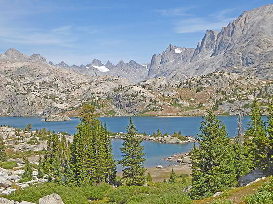
Island Lake and the peaks towering above Titcomb Basin
This very popular backpack leads to Island Lake (10,346-ft.), a stunning destination with great day hiking, good fishing and scenic campsites. The trail to the lake, if done in one day, is long and tiring with lots of ups and downs.
- Distance: 24.3 miles
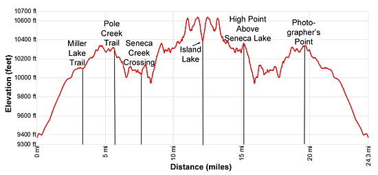
- Elevation: 9,340-ft. at Elkhart Park Trailhead
10,090-ft. at Junction Miller Lake Trail
10,350-ft. at Photographers Point
10,300-ft. at Junction Seneca Lake Trail
9,995-ft. at Low point west of Seneca Lake
10,375-ft. at High point above Seneca Lake
10,410-ft. at Junction Highline/Continental Divide Trails
10,625-ft. at Top of hill above Little Seneca Lake
10,490-ft. at Stream crossing
10,640-ft. at High point above Island Lake
10,410-ft. at Island Lake
Note: There is a lot of up and down along this trail. Based on GPS measurements, the trail gains over 2,600-ft. and loses almost 1,600-ft. on its way to Island Lake. - Difficulty: strenuous
- More Hikes in:
Elkhart Park / Wyoming's Wind River Range
Introduction
Breathtaking panoramas, great hiking, good fishing and scenic campsites combine to make Island Lake one of the most popular destinations in the Wind River Range. The shortest way to reach the lake is along the heavily trafficked route from Elkhart Park that, if done in one day, is tiring and strenuous due to numerous ascents and descents. Many parties take two days to reach the Island Lake, camping at one of the lakes along the way.
The effort to reach the lake is amply rewarded with numerous day hiking opportunities. Favorite hikes in the area include the scenic trail to stunningly Titcomb Basin and the terrific walk to Indian Pass that climbs through the starkly beautiful Indian Basin. Parties looking for an easier day can wander around Island Lake, visiting waterfalls and the pretty lake basin to the northeast of the lake. Other hiking destinations include the trail/route to Pass 11,020 on the divide between the Island Lake and Wall Lake and a trip to the Jean Lakes along the northbound Highline Trail.
Most hikers reach Island Lake from Elkhart Park using a combination of the Pole Creek, Seneca Lake, Highline and Indian Pass trails. The 12.1 mile (one-way) route spends the first 4.0 miles climbing on moderate grades through predominately viewless forest. Miller Park’s meadows, at 3.3 miles, offers a brief break from the monotony with distant views of the high peaks in the northern portion of the Wind River Range.
Beyond the meadows the landscape changes as the trail now climbs through forest and small meadow set amid rock outcroppings and granite knobs, reaching Photographer’s Point at 4.6 miles. This aptly names viewpoint offers a preview of coming attractions with a stunning panorama of the high peaks rising between the Upper Fremont Valley and Island Lake.
Past the viewpoint an undulating trail leads to a junction near Eklund Lake, at 5.6 miles, where we turn left (northwest) on the Seneca Lake trail. For the next 5.1 miles the trail follows a roller coaster route that ascends and descends through a fractured landscape, passing Barbara, Hobbs, Seneca and Little Seneca Lakes along the way. This section of the trail is quite tiring for anyone carrying a pack. As a consolation, the lakes and high ridges along the trail enjoy ever improving views of the high peaks.
After curving around the head of Little Seneca Lake the trail reaches a junction with the combined Highline/Continental Divide trails. Here the Seneca Lake trail ends and we turn left (northwest) on the northbound Highline/Continental Divide trails. Follow this rocky path for 0.4 miles as it climbs steeply to the top of a ridge and then descends to a junction. At the junction the Highline/Continental Divide trails turn left (northwest), we continue straight ahead on the Indian Pass trail toward Island Lake.
Below the junction the Indian Pass trail traverses a pretty basin with views of Mount Helen, Mount Sacagawea and Fremont Peak towering above Titcomb Basin. A wall of granite summits, including Bow Mountain, Arrowhead Peak and the Titcomb Needles, fill the skyline to the northwest.
Beyond the basin the trail climbs over a second ridge and then descends on moderate to steep grades to a stunning viewpoint. Here the high peaks towering above Titcomb and Indian Basins form a breathtaking backdrop for Island Lake. The jagged 13,000-ft. summits of Twin Peaks, Mt. Woodrow Wilson, the Sphinx, Bob’s Tower and Miriam Peak rise above the head of Titcomb Basin. Mount Helen, Mount Sacagawea and Fremont Peak rim the basin’s eastern wall while American Legion Peak, the Titcomb Needles and Peak 12450, to name a few, form the western wall. Jackson Peak and Ellingwood Peak, along with a number of unnamed summits, tower above Indian Basin to the northeast. Closer at hand, Island Lake is set amid granite knolls with Elephant Head Peak rising to the east.
From the viewpoint the trail descends steeply to an unmarked junction above the southeastern shore of Island Lake (10,346-ft.) at 12.1 miles. Here the trail branching to the left (northwest) leads to scenic campsites along the lake’s southwestern shore. The Indian Pass trail continues straight ahead (northeast) toward Indian and Titcomb Basins.
Island Lake is an extremely popular destination, so don’t expect solitude. On the knoll at the south end of the lake are tightly packed, overused campsites. Please try to avoid camping here. The further you get from the junction at the south end of the lake, the more likely you will find a campsite with some privacy. Additional campsites are located along Island Lake’s northeastern shore and in the basin above the waterfall on the northeast side of the lake. Please respect the areas closed for regeneration along Island Lake’s heavily used eastern shore.
Campsites are also located in Titcomb and Indian Basins. Both basins are above timberline so campsites are exposed with large rocks offering the only protection. Finding legal campsites that are at least 200-ft. from trails and water is somewhat challenging in both basins. Hanging food is also problematic due to the lack of trees. You will need to find a large boulder to hang your food or carry a bear container.
Backpack Segments
- Segment 1: Elkhart Park to Island Lake
- --- Side Trip: Titcomb Basin
- --- Side Trip: Indian Basin and Pass
- --- Side Trip: Island Lake Waterfall Hike
- Segment 2: Island Lake to Elkhart Park
Elevation Profile
Mileage and Elevation Detail
| Miles | Elevation | Destination | |
|---|---|---|---|
| 0.0 | 9,340- ft. | Elkhart Park Trailhead | |
| 3.3 | 10,090-ft. | Junction Miller Lake Trail | |
| 4.6 | 10,350-ft. | Photographers Point | |
| 5.6 | 10,300-ft. | Junction Seneca Lake Trail | |
| 5.7 | 10,220-ft. | Barbara Lake | |
| 6.9 | 10,075-ft. | Hobbs Lake | |
| 8.3 | 9,995-ft. | Low point west of Seneca Lake | |
| 9.1 | 10,375-ft. | High point above Seneca Lake | |
| 9.7 | 10,274-ft. | North shore of Seneca Lake | |
| 10.2 | 10,360-ft. | Foot of Little Seneca Lake | |
| 10.7 | 10,410-ft. | Junction Highline/Continental Divide Trails | |
| 11.1 | 10,560-ft. | Junction Highline and Indian Basin Trails | |
| 11.8 | 10,640-ft. | High point above Island Lake | |
| 12.1 | 10,410-ft. | Island Lake |
Trailhead Driving Directions
Directions from Pinedale: From the intersection of Pine Street (US 191) and North Tyler Ave (the Pinedale Tourism office is located on the northeast corner) in Pinedale, WY, drive east on Highway 191 (East Pine Street) for 0.3 miles and bear left onto Fremont Lake Road. Follow this road for 14.3 miles and turn right into the large parking area for the Elkhart Park/Pole Creek Trailhead. After the first 3.0 miles the road will turn into Skyline Drive/Forest Service Road 370740. The trailhead is located at the northeast end of the parking lot between the outhouse and the trailhead kiosk. It should take about 25 minutes to drive the trailhead. The last section of the road has some holes and uneven spots.
Trail Resources
Trail Photo Gallery / Trail Map
Basecamp(s) Information:
Elkhart Park
Region Information:
Wyoming's Wind River Range
Other Hiking Regions in:
Wyoming