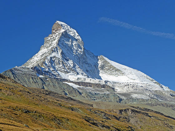
The north face of the Matterhorn and the Matterhorn Glacier
The Matterhorn is the star of the show on this scenic hike starting at Schwarzsee, a popular viewpoint atop the Matterhorn Plateau. Competing for your attention are splendid views of the high peaks rimming the Zmutt valley along with more distance views of the Findel and Monte Rosa areas.
See Trail Detail/Full Description
- Distance: 7.3 miles (one way) to Schwarzsee to Zermatt
- Elevation: 8,490-ft. at Trailhead
8,490-ft. at Schwarzsee to Zermatt - Elevation Gain: -3,190-ft. to Schwarzsee to Zermatt
- Difficulty: moderate
- More Hikes in:
Zermatt / The Valais
Why Hike Schwarzsee to Zermatt
Breathtaking views of the Matterhorn are your constant companion along much of this scenic hike. Starting at Schwarzsee atop the Matterhorn Plateau, the trail descends through meadows along the south side of the Zmutt Valley accompanied by impressive views of the Matterhorn’s north face. The Ober Gabelhorn and Dent Blanche fill the skyline across the valley to the north.
The hike reaches the floor of the Zmutt Valley and then crosses to the north side of the valley at the site of the Grande Dixence Hydroelectric project, set amid the glacial debris left by the receding Zmutt Glacier. It is not a pretty sight by happily the views of the Matterhorn and the high peaks forming the cirque at the head of the Zmutt valley will divert your attention.
On the north side of the valley the trail descends through pretty meadows with fine views of the Matterhorn and, in the distance to the east, Monte Rosa and the high peaks towering above the Findel Glacier. The final leg of the hike travels through Zmutt, a lovely little village of wood houses, and then passes historic grain storehouses and small Alps on its way back to Zermatt.
The trail can be shortened by returning along the south side of the Zmutt Valley. It is also possible to walk to Schwarzsee instead of taking the gondola. Walking to the Matterhorn Plateau will add 4.0 to 5.0 miles to the hike depending on the route.
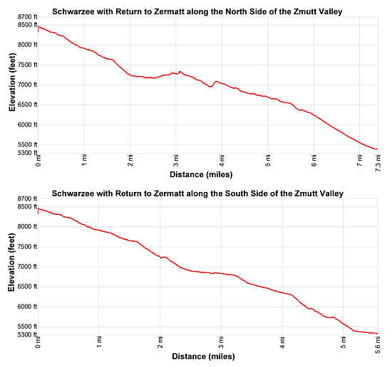
Elevation Profile
| Support our Site |
Trail Resources
Trail Detail/Full Description / Trail Photo Gallery / Trail Map
Basecamp(s) Information:
Zermatt
Region Information:
The Valais
Other Hiking Regions in:
Switzerland