Best Hikes in Grant Village / Lodgepole, California
Location: California's Southwestern Sierra
On Highway 198 / the Generals Highway, 79 miles southeast from Fresno, CA and 56 miles northeast of Visalia, CA.
By: Diane Greer
Lodgepole is the perfect base camp for visiting the heart of Sequoia National Park. Hikers can spend days wandering among towering sequoias or exploring a world of sparkling lakes set amid rugged granite peaks in the high sierras. View Lodgepole Info
Introduction

Lodgepole (6,700-ft.) is a great base camp for visiting the heart of Sequoia National Park. Hikers can spend days wandering among towering sequoias or exploring a world of sparkling lakes set amid rugged granite peaks in the high sierras.
The area is a hub for park activities, featuring a visitor center, campground and small village offering food services, a market, showers, a laundry and a post office. Nearby are additional accommodations and services in park lodges and campgrounds.
Lodgepole Hiking Trails
Distance: 13.8 miles (Round Trip)
Difficulty: strenuous-difficult
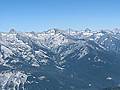
Alta Peak offers some of the best views in the southern Sierras. From its lofty summit breath-taking vistas extend from the Sierra Crest, the Great Western Divide and the Kaweah Peaks to the foothills of the San Joaquin Valley.
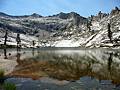
Lakes Trail - Heather, Emerald and Pear Lakes ![]()
Distance: 8.2 - 12.8 miles (Round Trip)
Difficulty: moderate-strenuous
The Lakes Trail, one of the most popular hikes in Sequoia National Park, climbs through dense forest to a landscape of polished granite dotted with four beautiful lakes and set amid a backdrop of rugged ridges anchored by Alta Peak (11,204-ft.).
Distance: 3.0 - 7.6 miles (Loop)
Difficulty: easy-moderate
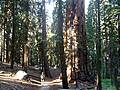
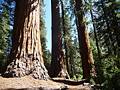
This great loop hike through the heart of the aptly named Giant Forest visits some of the world’s largest trees and traverses amazing groves of these stately giants.
Distance: 7.3 - 9.6 miles (Loop)
Difficulty: moderate
Leave the crowds behind and enjoy a peaceful hike through one of Sequoia-Kings Canyon National Park’s largest sequoia groves.
View Hikes by Area:
California's Southwestern SierraLodgepoleMineral King
Around Town

Lodgepole (6,700-ft.) is nestled at the foot of the canyon of the Marble Fork of the Kaweah River. From here, or nearby Wolverton, scenic trails climb to the park’s high country, a landscape of glacier carved basins framed by sheer granite ridges and soaring peaks. In my opinion the Lakes Trail, which visits four photogenic lakes, and the Alta Peak trail, a steep climb to one of the best viewpoints in the park, are the top hikes in the area.
For a shorter hike try the 3.4 miles round trip Tokopah Trail. The hike offers great views of the glacially-carved granite canyon of the Marble Fork, including the soaring 1,800-ft. granite face of the Watchtower. The trail ends at a pretty cascade, Tokopah Falls. The trailhead is located at the east end of the Lodgepole Campground, just across a log bridge over the Marble Fork.
Just a 10 minute ride south of Lodgepole on Highway 198 is the Giant Forest, a 1,880-acre forested plateau containing some of the world’s largest trees. An excellent network of trails criss-cross the plateau roaming through groves of these remarkable giants, passing pretty meadows and traversing peaceful forests. See the Giant Forest Loop hike for driving direction and a description of one possible loop option. Park shuttle buses travel between Lodgepole, the Giant Forest and Crescent Meadow, located at the south end of the plateau, facilitating point-to-point hikes within forest.
Continuing south on Highway 198, 4.4 miles from Lodgepole is the Giant Forest Museum. The museum along with two interpretive trails provides great information on giant sequoias and the human history of the surrounding area. The Big Trees trail (1.2 mile loop) starts from the museum and loops around sequoia-lined Round Meadow. Interpretive signs along the path explain the ecology of the sequoias. On the south side of Highway 198 is the Hazelwood Trail (1.0 miles loop) that includes displays outlining the story of man’s relationship with the big trees.
If time allows consider taking the shuttle bus or drive along the Moro Rock-Crescent Meadows Road. The narrow, winding 3-miles long road (not recommended for trailers or RV’s) heads southeast from Highway 198 / the General’s Highway just south of Giant Forest Museum and leads to Crescent Meadows. Located along the road are the Auto Log, the Tunnel Log, the Parker Group, a great cluster of giant sequoias, and Moro Rock.
From the Moro Rock parking area a very popular trail climbs 400-steps, chiseled into the rock, to the top of the rock where there are great views of the Giant Forest plateau, the Middle Fork of the Kaweah River canyon and the Castle Crags across the canyon. To the east/southeast the peaks of the Great Western Divide frame the skyline.
At the end of the road is Crescent Meadow where a nice, easy 2.2 mile hike loops around Long and Crescent Meadows, visiting the Burial Tree, Tharps Log and the Chimney Tree along the way. During the summer the meadows are filled with wildflower. The area is also a good place to see bears.
A stroll out to Eagle View is another great option while in the Crescent Meadow area. The 3.0 mile round trip hike travels through forest on the High Sierra Trail for 0.5 miles and then leaves the trees behind as it travels a short distance along the north side of the Middle Fork of the Kaweah River canyon to Eagle View. From here you can look back to Moro Rock to the west, down to the Middle Fork of the Kaweah River, and to the east toward the glaciated peaks of the Great Western Divide.
Nearby Attractions
To the northwest of Lodgepole is the smaller Grant Grove, home to the General Grant Tree, the third largest sequoia in the world. A good network of hiking trails offers a variety of options for viewing the area’s big trees. To reach Grant Grove from Lodgepole, turn right onto CA 198 and follow the road for 24.6 miles to the junction with Highway 180. Turn right on Highway 180 and drive for 1.6 miles. The trip along the winding park roads should take about 45 minutes.
There are a number of great hikes along the way. A little over 6.5 miles from Lodgepole is the trail to Little Baldy. This 3.4 mile round-trip moderately steep hike climbs to a rocky summit with wonderful views of the North Fork and Marble Fork Canyons. Another great viewpoint is located atop Big Baldy, 16.5 miles from Lodgepole. This moderate 4.0 miles round trip hike takes you to breathtaking views of Redwood Canyon and the peaks along the Kings-Kaweah and Great Western Divides.
If you are in the mood for a longer hike try one of the trails in Redwood Canyon. The area provides the opportunity to visit one of the largest sequoia groves in the park in relative solitude. See the Redwood Canyon Loop for driving directions and a description of the hiking options.
Grant’s Grove includes a visitor center, campgrounds, cabins, a small market, restaurant, showers, post office and gift shop. The most popular hike in the Grove is the General Grant Tree Trail, a 0.5 miles loop visiting its namesake tree. Along the way the busy and often crowded trail passes a number of other impressive giants. To reach the trailhead drive north from the Grant Grove Village for a short distance and turn left (west) on the Grant Tree Road. Follow the road for 0.8 miles to the large parking area for the General Grant Tree.
If you wish to leave the crowds behind try the North Grove Loop, a 1.5 mile trail starting from the west end of the General Grant Tree parking lot. The trail wanders through a mixed conifer forest scattered with sequoias, passing pretty meadows and creeks along the way.
From Grants Grove to Cedar Grove, also known as Roads End, in Kings Canyon, is a 35 mile drive that will take about an hour. The Kings River runs through this scenic valley (3,500-ft.) that is surrounded by towering cliffs and features pretty waterfalls. Facilities include a ranger station, campground, lodge and a village area with food services, a market, gift shop, showers and laundry facilities.
There are a number of nice short hikes in the area. See the Cedar Grove Day Hiking for a list of short hikes in the area. Due to the low altitude it can get quite hot in Cedar Grove during the summer. Be sure to carry plenty of water.
Food, Lodging and Services
As previously mentioned, Lodgepole is a hub for park activities, featuring a visitor center, campground with 214 sites and small village offering food services, a market, showers, a laundry and a post office. The campground has a few reserved sites but is mostly first-come, first serve.
Nearby is the Wuksachi Lodge, a 102 unit motel with a full service restaurant, cocktail lounge and small retail shop. The lodge is located 1.6 miles from Lodgepole. Turn right onto Highway 198 from Lodgepole to reach the facility.
The Dorst Creek Campground is located 18.2 miles northwest of Lodgepole off Highway 198. Reservations can be made for the 222 sites at the campground through Recreation.gov.
Midway between Wuksachi and Grant Grove is the Montecito-Sequoia Lodge. Accommodations at the lodge and family camp, located in the Sequoia National Forest, include cabins and lodge rooms.
Grant Grove features a visitor center, three campgrounds, rustic cabins and tented cabins, a small market, restaurant, showers, post office and gift shop. The campgrounds, located within a short drive of the visitor center are Azalea (110 sites, first-come, first-serve), Crystal Spring (36 individual and 15 group, first-come, first-serve) and Sunset (157 sites, first-come, first-serve). Further afield in Cedar Grove there are 4 campgrounds .
I strongly recommend bringing food with you when visiting the park. There is a very limited selection of food in the small groceries at Lodgepole and Grant Grove. Other options for eating include the restaurants at Lodgepole, the Wiksachi Lodge and Grant Grove. Food should not be left in your vehicle. Bear boxes are provided at campgrounds and trailheads for food storage.