Best Hikes in Dubois
Location: Wyoming's Wind River Range
Located on US 26/US 287, 74 miles northwest of Lander, Wyoming and 85.5 miles northeast of Jackson, Wyoming.
Introduction
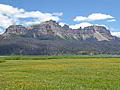
Dubois, Wyoming is located between the Wind River Range to the south and the southern Absaroka Mountains to the north. The Trail Lake trailhead provides access Wind River trails along the branches of Torrey Creek including to the popular Glacier Trail leading to Gannett Peak, the Lake Louise trail, Whiskey Mountain trail and Ross Lakes area.
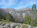
To the north/northeast are the southern Absaroka Mountains, protected by the Washakie Wilderness in the Shoshone National Forest and the Teton Wilderness in the Teton National Forests. This area feature scenic trails leading though a vast and remote backcountry with expansive meadows, forests, peaks and plateaus.
Dubois Hiking Trails
Distance: 6.8 - 9.2 miles (Round Trip)
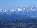
Far reaching views, extending to the Tetons, the peaks gracing the southern end of the Absaroka Range and the summits of the northern Wind River Range, are the rewards of the hike to the saddle between Whiskey Mountain’s twin summits.
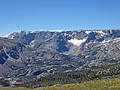
Distance: 6.5 - 16.0 miles (Round Trip)
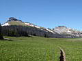
This hike ascends East Torrey Creek to Bomber Basin and then climbs the slopes of Arrow Mountain to an overlook at 10,000-ft. and Pass 10,895-ft. Views encompass Torrey Peak, Middle Mountain, Whiskey Mountain, the Absaroka Range and, at the pass, Horse Ridge and Burro Flats.
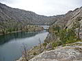
Distance: 4.6 miles (Round Trip)
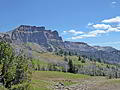
A short hike through a rugged landscape leads to Lake Louise, a beautiful body of water nestled beneath the steep walls of the West Torrey Creek Canyon formed by Whiskey Mountain, to the north, and Middle Mountain, to the south.
View Hikes by Area:
Wyoming's Wind River RangeBig SandyElkhart ParkNew Fork LakesGreen River LakesDubois