Best Hikes in Wyoming's Wind River Range
Location: In west-central Wyoming, accessible from Highway 191 to the southwest and Highways 26 and 287 to the northeast.
Featured Hikes
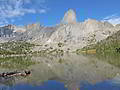
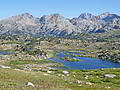
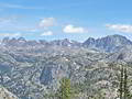
Washakie Pass, Lizard Head, Cirque of the Towers Loop ![]()
Distance: 36.0 miles (Loop)
This backpack, one of my favorite trips in the southern Wind River Range, climbs over two panoramic passes, crosses the spectacular Lizard Head Plateau and visits the amazing Cirque of the Towers.
Distance: 6.8 - 9.2 miles (Round Trip)
Far reaching views, extending to the Tetons, the peaks gracing the southern end of the Absaroka Range and the summits of the northern Wind River Range, are the rewards of the hike to the saddle between Whiskey Mountain’s twin summits.
Distance: 6.5 - 16.0 miles (Round Trip)
This hike ascends East Torrey Creek to Bomber Basin and then climbs the slopes of Arrow Mountain to an overlook at 10,000-ft. and Pass 10,895-ft. Views encompass Torrey Peak, Middle Mountain, Whiskey Mountain, the Absaroka Range and, at the pass, Horse Ridge and Burro Flats.
Distance: 6.2 - 10.6 miles (Round Trip)
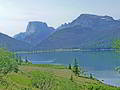
This easy, popular day hike features terrific views of the Green River Lakes, the Green River and Squaretop Mountain.
Big Sandy to Elkhart Park via Fremont and Highline Trails ![]()
Distance: 53.8 miles (One Way)
Panoramic views of the high peaks along the Continental Divide, lovely lake basins and varied terrain are the hallmarks of this terrific point-to-point backpack along the Fremont and Highline trails.
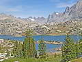
Green River Lakes to Island Lake & out Elkhart Park ![]()
Distance: 41.8 miles (One Way)
The Highline Trail between Green River Lakes and Island Lakes is popular and deservedly so. A relatively easy climb leads to my favorite section of the Highline between Summit and Island Lakes, featuring photogenic peaks towering above beautiful alpine meadows and scenic lakes.
New Fork Lakes to Island Lake & out Elkhart Park ![]()
Distance: 45.7 miles (One Way)
Towering granite walls, glorious alpine meadows, beautiful lakes and panoramic views of soaring peaks are the hallmarks of this terrific point-to-point backpack that follows the scenic New Fork and Highline trails to Island Lake. Return to civilization via the Seneca Lake and Pole Creek Trails to Elkhart Park.
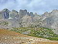
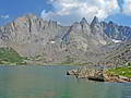
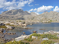
Hailey Pass - Lizard Head - Cirque of the Towers Loop ![]()
Distance: 40.3 miles (Loop)
This great loop trip in the southern Wind River Range climbs over Hailey and Jackass Passes, crosses the spectacular Lizard Head Plateau and visits the amazing Cirque of the Towers.
Texas Pass - Cirque of the Towers - Jackass Pass Loop ![]()
Distance: 24.5 miles (Loop)
For experienced backpackers only, this trip follows a combination of trails and off-trail routes to cross Texas Pass into the stunning Cirque of the Towers. Complete the loop by exiting the Cirque via the Jackass Pass.
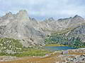
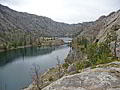
Distance: 24.3 miles (Round Trip)
This very popular backpack leads to Island Lake (10,346-ft.), a stunning destination with great day hiking, good fishing and scenic campsites. The trail to the lake, if done in one day, is long and tiring with lots of ups and downs.
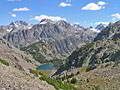
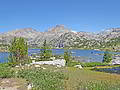
Big Sandy to the Cirque of the Towers via Jackass Pass ![]()
Distance: 18.0 miles (Round Trip)
The shortest route to the Cirque of the Towers, an amazing spectacle of jagged peaks and spires rising over 12,000-ft. above Lonesome Lake, is via Big Sandy Lake and Jackass Pass trails.
Distance: 32.6 miles (Loop)
The Pole Creek Trail, in conjunction with a segment of the Highline trail, is used to create an interesting and highly scenic loop that explores the Cook Lakes, crosses panoramic Lester Pass, visits the stunning Island Lake area and then returns to the trailhead via the Seneca Lake and Pole Creek trails.
Distance: 9.4 miles (Round Trip)
Photographer’s Point, one of the most popular day hikes in the Wind River Range, leads to a breathtaking overlook where a sea of jagged summits along the western side of the Continental Divide fill the horizon.
Distance: 4.6 miles (Round Trip)
A short hike through a rugged landscape leads to Lake Louise, a beautiful body of water nestled beneath the steep walls of the West Torrey Creek Canyon formed by Whiskey Mountain, to the north, and Middle Mountain, to the south.
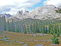
Hailey Pass - Washakie Pass Loop ![]()
Distance: 35.5 miles (Loop)
This rewarding loop hike climbs over two panoramic passes on the Continental Divide and visits three beautiful lake basins.
Big Sandy to Skull Lake Basecamp ![]()
Distance: 19.8 - 20.4 miles (Round Trip)
Families and parties looking for an easy backpack into a basecamp with great day hiking and fishing opportunities will love the trip to the Washakie Creek and East Fork Valleys featuring splendid scenery with plenty of high peaks and lovely lakes.
New Fork-Peak-Elbow-Doubletop Loop ![]()
Distance: 43.0 miles (Loop)
A dramatic canyon and five beautiful alpine lake basins set amid the high peaks of the northern Wind River Range are the highlights of this loop backpack out of the New Fork Lakes trailhead.
New Fork-Doubletop-Palmer Loop ![]()
Distance: 47.8 miles (Loop)
This great loop backpack out of New Fork Lakes travels through a variety of terrains ranging from impressive canyons with sheer granite walls to beautiful alpine lake basins surrounding by towering peaks.
View Hikes by Area:
Big SandyElkhart ParkNew Fork LakesGreen River LakesDubois
The Region, the Hikes & the Base Camps
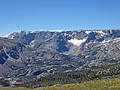
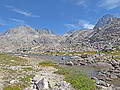
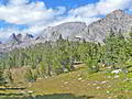
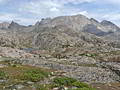
The core of the Wind River Range, a backpacker’s paradise, runs for 80 miles along the crest of the Continental Divide in west-central Wyoming from Green River Lakes in the northwest to the Big Sandy Opening in the southeast. Forty peaks soar above 13,000-ft. and over 100 summits top 12,000-ft. This amazing collection of lofty granite peaks tower above breathtaking alpine meadows and forests studded with over 2,300 lakes and ponds. Two national forests and three wilderness areas, along with the Wind River Indian Reservation, protect huge swathes of this incredible landscape.
While there are certainly day hiking opportunities in the range, the “Winds” are best experienced on a backpack. The quintessential backpack along Continental Divide Trail, traversing the length of the range for 80 miles, showcases the Wind River's high peaks, glistening lakes and gorgeous meadows. In the south the Cirque of the Towers, an amazing spectacle of jagged peaks and spires rising over 12,000-ft. above Lonesome Lake, is a mecca for backpackers and climbers. Stunning Island Lake and Titcomb Basin, classic destinations in the north-central section of the range, offers backpackers the perfect basecamp for day hiking, exploring and fishing.
Beyond the popular routes backpacking options abound. The established network of over 600-miles of trails, along with a dizzying array of off-trail routes, creates seemingly endless opportunities for backpackers. Once you experience the range you will be hooked and understand why many of the people you run into along the trail have been visiting the range for years.
I’m certainly hooked and have backpacked the Winds for over 20-years. Before each trip I pour over maps to create backpacks that explore favorite parts of the ranges along with off the beaten path destinations. After all this time the Winds still offer plenty of new places to explore with stunning, jaw-dropping scenery.
The backpacks in this section, which is still under development, are intended to help you start exploring the range. The trips range from 2-10 nights and are best done from mid-July to mid-September. There are countless ways to link backpacking segments and side trips to create a dream trip. My focus is primarily on the westerns section of the Winds out of four main trailheads, Big Sandy, Elkhart Park, New Fork Lakes and Green River Lake, all reachable from Pinedale, Wyoming. As time and energy allow, I will add trip on the eastern side of the range out of Dubois.
Any suggestions on how to improve this section of the website are greatly appreciated.
Base Camp Information: Big Sandy / Elkhart Park / New Fork Lakes / Green River Lakes / Dubois