Best Hikes in The Valais
Featured Hikes
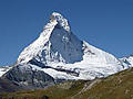
Distance: 7.6 - 12.3 miles (Loop)
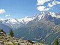
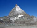
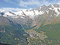
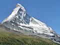
Our favorite hike in Zermatt features magical views of the majestic Matterhorn and stunning panoramas of the 4,000-meter peaks towering above the Zermatt area.

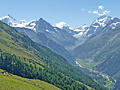
Col de Torrent: Les Hauderes to Lac de Moiry ![]()
Distance: 7.3 miles (One Way)
Hikers making the steep climb over the Col de Torrent from La Sage, Villaz to Lac de Moiry are rewarded with splendid views of the high peaks and glaciers towering above the Val d’ Herens, Val d' Arolla and the Val de Moiry.
Distance: 9.7 miles (One Way)
Highlights of this scenic walk between St. Luc and Zinal include magnificent views of the high peaks and glaciers gracing the skyline at the head of the Zinal Valley and panoramic views of the rugged summits towering above the Rhone and Anniviers Valleys.
Zinal to Gruben via Forcletta Pass ![]()
Distance: 10.9 miles (One Way)
This scenic route between the Val d'Anniviers and Gruben crosses Forcletta Pass and features panoramic views of the high peaks towering above the head of the Zinal and Turtmann Valleys.
Gruben to Jungen via Augstbord Pass ![]()
Distance: 8.2 miles (One Way)
One of my favorite hikes in the Valais is the steep, scenic climb over Augstbord Pass leading to an overlook with stunning, panoramic views of the Bernese Alps and the high peaks towering above the Mattertal from Stalden to Zermatt.
Gspon to Kreuzboden (Gspon Hohenweg) ![]()
Distance: 8.6 miles (One Way)
The Gspon Hohenweg is another of the great high routes in the Saas Valley. This scenic trail, traversing high above the east side of the valley, features wonderful panoramic views of the 13,000-ft. (4,000-meter) peaks of the Mischabel Range.
Grachen to Saas Fee (Hohenweg Saas Fee) ![]()
Distance: 10.8 miles (One Way)
The Saas Fee Hohenweg is one of the classic hikes in the Valais. The challenging trail follows a high route along the west side of the Saastal with stunning, nonstop views of the glacier-clad peaks towering above the Saas Valley and the Bernese Alps to the north.

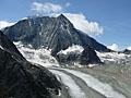
Schonbielhutte (Schonbiel Hut) ![]()
Distance: 13.7 miles (Round Trip)
Two great trails with terrific views of the Matterhorn are combined to create a fantastic hike to Schonbiel Hut, sitting atop a scenic overlook at the head of the Zmutt Valley.
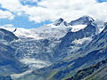
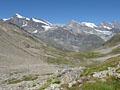
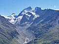
Distance: 6.0 - 13.2 miles (Round Trip)
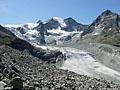
Two rivers of ice, surrounded by towering peaks, flow down the head of the Val d'Herens. This hike ascends the peaceful valley to the stunning viewpoint at Bricola, a high alp overlooking this spectacle of rock and ice. Extend the hike to Les Manzettes for even better views.
St. Luc / Hotel Weisshorn to Gruben via Meidpass ![]()
Distance: 6.8 - 7.8 miles (One Way)
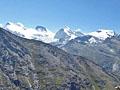
Meidpass features splendid views of the glacier clad peaks of the Turtmann Valley, the summits towering above the Rhone, Anniviers and Moiry Valleys along with distant views of Grand Combin and Mont Blanc, rising to the southwest beyond the Anniviers Valley.
Distance: 7.0 - 8.5 miles (Loop)
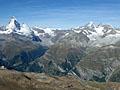
Great views accompany almost every step of this hike leading to Gornergrat, a glorious overlook with panoramic views of 20 peaks over 13,000-ft. (4,000-meters) high.
Distance: 5.6 - 10.5 miles (Round Trip)
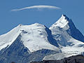
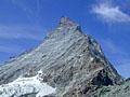
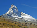
The short, steep hike to Hornlihutte offers a unique, up-close opportunity to experience the iconic Matterhorn from the base of the most popular climber’s route to the summit.
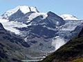
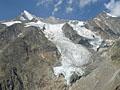
Distance: 4.0 - 6.7 miles (One Way)
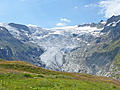
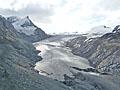
This short hike leads to the Moiry Hut with stunning bird’s-eye-views of the Moiry Glacier. Extend the hike with a scenic walk along the west side of the Lac de Moiry to the Moiry Barrage (dam) at the foot of the lake.

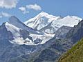
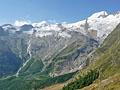
Distance: 12.6 miles (Round Trip)
The long and strenuous climb to the Cabane Arpitetta features wonderful views of the glacial cirque at the head of the Arpitetta valley, dominated by the Weisshorn, Zinalrothorn, Moming massif and the Moming glacier.
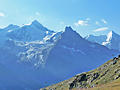
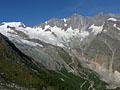
Distance: 12.2 - 14.1 miles (Round Trip)
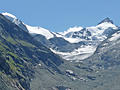
Magnificent views of one of the most stunning glacial cirques in the Pennine Alps is the reward for hikers completing this long and very strenuous hike to the Cabane du Grand Mountet at the head of the Zinal Valley.
Col Torrent: Les Hauderes to Cabane de Moiry ![]()
Distance: 9.5 miles (One Way)
A strenuous day hiking over the Col de Torrent followed by a climb to the Cabane de Moiry features amazing views of the glacier-clad summits towering above the Val d’Herens, the Val d’Arolla and the Val de Moiry. The challenging climb to the hut features breathtaking view of the Moiry Glacier.
Distance: 9.4 miles (Round Trip)
A stiff climb to a high belvedere features dramatic, nonstop views of the summits rising above the east side and the head of the Zinal Valley. Along the way the path visits the Petit Mountet hut and travels through beautiful meadows with see-forever views.
Mattmark to Heidbodme via Jazzilucke ![]()
Distance: 9.6 - 10.8 miles (One Way)
An great hike traversing two beautiful valleys connected by a challenging, exposed trail traveling between the Jazzilucke and Antrona passes on the Swiss-Italian border.
Distance: 4.1 miles (One Way)
Stunning, panoramic views of the Matterhorn and the summits rimming the Zermatt area are the highlights of this scenic hike through the stark landscape left by retreating glaciers. En route pass glacial lakes, colorful rock outcroppings and learn about the local geology.
Kreuzboden to Saas Almagell (Hohenweg Kreuzboden) ![]()
Distance: 6.0 - 6.3 miles (One Way)
This scenic walk, with panoramic views of the Mischabel Range, traverses high above the east side of the Saas Valley before entering the beautiful Almageller Valley. End the hike by descending to Saas Almagell or take the challenging Adventure Trail to Furggstalden.
Distance: 5.6 - 7.3 miles (One Way)
The Matterhorn is the star of the show on this scenic hike starting at Schwarzsee, a popular viewpoint atop the Matterhorn Plateau. Competing for your attention are splendid views of the high peaks rimming the Zmutt valley along with more distance views of the Findel and Monte Rosa areas.
Distance: 3.8 - 9.1 miles (Round Trip)
The second highest hiking trail in Switzerland leads to the summit of the Oberrothorn (11,200-ft.) with splendid, 360-degree views of 38 peaks over 13,000-ft. (4,000-meters).
Distance: 10.4 miles (Round Trip)
A lovely walk up a pretty valley leads to a remote and wild saddle on the Swiss-Italian border, offering a degree of solitude not found on many hikes around the Saas Fee area.
Distance: 7.2 miles (Round Trip)
This beautiful trail, showcasing the peaks rising along the east and south sides of the Arolla Valley, leads to a pass on a rugged ridge with fine vistas of the Glacier de Cheilon flowing down the Val des Dix, Mont Blanc de Cheilon and Le Pleureur.
Hannig to Saas Fee (Gemsweg Part 1) ![]()
Distance: 4.0 miles (One Way)
Few trails in the Saas Fee area feature the scenic bang for the miles hiked as the Gemsweg (Chamois Path) from Hannig to Saas Fee. A glacial lake, glistening waterfalls and ever changing views of the high peaks towering above Saas Fee are just a few of the highlights along this delightful trail.
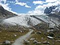
Cabane de Moiry to Zinal via Col de Sorebois ![]()
Distance: 7.5 - 9.9 miles (One Way)
This hike, part of the Haute Route, also makes for a great point to point day hike with lovely views of the Zinal and Moiry Valleys along with dramatic up-close views of the Moiry Glacier. The hike can be walked in either direction.
Distance: 7.2 miles (Round Trip)
This scenic trail up the beautiful Montagne d’Arolla valley heads to the Pas de Chevres on a rugged ridge with views of the Glacier de Cheilon, Mont Blanc de Cheilon, Le Pleureur and the peaks rising along the east side of the Arolla Valley.
Distance: 8.2 miles (Loop)
This steep hike leads to Roc de la Vache, a panoramic overlook high above the east side of the Zinal Valley.
Plattjen to Saas Fee (Gemsweg Part 2) ![]()
Distance: 3.9 miles (One Way)
Great views of the Mischabel peaks towering above Saas Fee and the Saas Valley are the highlights of this short trail descending from Plattjen to Saas Fee along the Gemsweg.
Distance: 10.4 miles (Round Trip)
This trail starts at the scenic overlook at Heidbodme, with panoramic views of the peaks towering above the Saastal. The path then travels on a high route along the eastern slopes of the Furgg Valley to Antrona Pass, a remote and wild saddle on the Swiss-Italian border.
Gorner Gletschertor and Gletschergarten ![]()
Distance: 3.8 - 5.9 miles (One Way)
This trail ascends through larch forests and rocky meadows in the lower Gorner Valley, exploring the rugged terrain left by the receding Gorner Glacier. Information boards show the glacier’s progress over time and provide insights on the area’s geology.
Mellig, Gibidum and the Bider Glacier ![]()
Distance: 2.7 - 6.4 miles (Loop)
Two lofty overlooks offer impressive bird’s-eye views of the glacial cirque surrounding Saas Fee, the Hohblam Glacier and the Fletschhorn-Weissmies group. The return to Saas Fee features views of the Bider Glacier and a walk through a pretty forest.
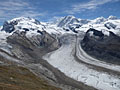
Distance: 7.8 - 8.6 miles (Round Trip)
This delightful hike leads to an overlook with front row seats to the amazing spectacle of massive rivers of ice flowing down the flanks of 4,000-meter peaks, joining with the Gorner Glacier to form the second largest glacial system in the Alps.
Distance: 4.5 miles (Round Trip)
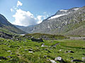
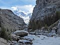
This lovely hike climbs steeply up the beautiful Trift Gorge beside a cascading stream, traveling through lovely wildflower-filled meadows to the basin at head of the gorge surrounded by a gorgeous cirque of rugged peaks adorn with glaciers.
Distance: 5.8 miles (Loop)
Pretty meadows, larch forests and nice views of the Matterhorn make this trail a good option for families and hikers looking for a pleasant half day walk.
Distance: 5.4 - 8.3 miles (Round Trip)
This moderately-easy trail leads to a peaceful overlook with wonderful views of the Findel Glacier flowing down the slopes of the Cima di Jazzi. Along the way hikers enjoy splendid views of the Matterhorn.
Sorebois to Lac de Moiry via Col de Sorebois ![]()
Distance: 5.6 - 8.9 miles (One Way)
Climb to the Col de Sorebois and then travel high above the Lac de Moiry to the Moiry Glacier. The walk is accompanied by fine views of the peaks towering above the Zinal, Moiry and Arolla valleys. Extend the hike by visiting the Moiry Hut or walking back along the lake to the dam.
Distance: 3.6 - 3.8 miles (Loop)
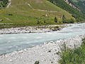
The pleasant Valley Loop hike, starting in the center of Zinal, travels on a wide path along the west side of the Navisence River, crosses two bridges and then returns to via the east side of the river. This is a great walk for families with small children and a good option on a rainy day.
Distance: 6.6 - 8.0 miles (Round Trip)
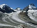
This trail offers a good perspective of the Zinal Valley, ascending through forests and meadows before climbing the slopes of an old moraine to the Cabane du Peitit Mountet. The hut features fine views of the Zinal Glacier and the ice-clad peaks rimming the upper Zinal Valley.
View Hikes by Area:
ZermattSaas FeeGrubenZinalLes HauderesArolla
| Support our Site |
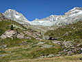
The Region, the Hikes & the Base Camps
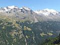
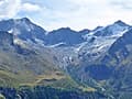
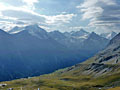
Located in the southwestern part of the country, the Valais is home to some of the most dramatic scenery in Switzerland. The high peaks of the Pennine Alps clad in sparkling glaciers tower above emerald green meadows, sprinkled with charming alpine village and, in some areas, world class resorts such as Zermatt and Saas Fee. Fifty peaks, including the Matterhorn, Monte Rosa and the Dom, soar over 4,000-meter, more than any other region in the Alps. An intricate network of hiking trails, the most famous being the Hikers Haute Route, interlace the region creating endless opportunities for hikers to explore the high peaks, cross panoramic passes and travel through scenic alpine valleys.
Base Camp Information: Zermatt / Saas Fee / Gruben / Zinal / Les Hauderes / Arolla