Best Hikes in Moab, Utah
Location: Southeast Utah
On US-191, 113 miles southeast of Grand Junction, Colorado, 158 miles northwest of Durango, Colorado and 230 miles southeast of Salt Lake City, Utah.
Moab Hiking Trails
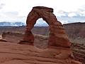
Distance: 3.1 miles (Round Trip)
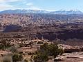
A short hike to a stunning, iconic arch perched on the edge of a huge sandstone bowl and framed by the scenic La Sal Mountains.
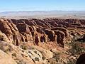
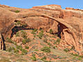
Distance: 1.8 - 7.7 miles (Loop)
Seven amazing arches set amid a landscape of weird and wonderful sandstone fins, spires and knobs are the rewards for hiking the Devils Garden Trail, my favorite trail in Arches National Park.
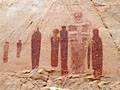
The Great Gallery in Horseshoe Canyon ![]()
Distance: 7.2 miles (Round Trip)
A nice hike to the Great Gallery, a phenomenal Barrier Canyon style rock art panel in a remote, detached unit of Canyonlands National Park.
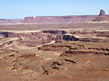
Distance: 5.0 - 12.2 miles (Round Trip)
This trail offers options for all levels of hikers as it travels through diverse landscapes with terrific view of the maze of canyons and red rock formation beneath the Island in Sky mesa. Far reaching vistas stretch east to the La Sal Mountains and south to the Abajo Mountains.
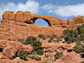
Distance: 0.5 - 2.0 miles (Loop)
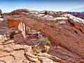
A photographer’s delight, this trail visits North Window, South Window, Turret Arch, and Double Arch, features great views of the areas distinctive rock formations and includes distant vistas of the La Sal Mountains.
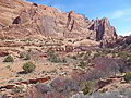
Distance: 4.2 - 5.8 miles (Round Trip)
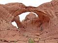
The trail to Double O Arch is one of the quintessential hikes in Arches National Park, featuring five notable arches along with views of an amazing concentration of sandstone fins, whimsical spires and sculpted knobs.
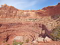
Mill Creek Canyon (North Fork) ![]()
Distance: 1.6 - 5.0 miles (Round Trip)
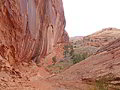
Towering sandstone walls, a perennial stream, waterfalls, swimming holes and rock art are the highlights of this interesting trail exploring scenic Mill Creek Canyon in southeast of Moab.
Distance: 2.5 miles (Round Trip)
A short, relatively easy trail leads to stunning Corona Arch and its fascinating neighbor, Bowtie Arch, situated in a huge sandstone amphitheatre high above the northwest wall of Bootlegger Canyon.
Distance: 0.9 - 1.8 miles (Round Trip)
Stroll beneath soaring sandstone formations topped with sculpted pinnacles, towers and spires on this short, highly scenic hike through a dramatic canyon in Arches National Park.
Distance: 4.9 - 7.3 miles (Round Trip)
Fine views of the Behind the Rocks and the La Sal Mountains along with the option to see great rock art panels make this a recommended hike.
Distance: 8.3 miles (Loop)
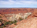
This interesting and challenging trail travels around Upheaval Dome, a fascinating geological feature in the Island in the Sky district of Canyonlands National Park. The trail, recommended for experienced hikers only, descends rugged Upheaval Canyon and climbs out via a beautiful and difficult trail up the Syncline Valley.
Distance: 2.3 miles (Loop)
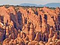
The Fiery Furnace hike travels through a fascinating labyrinth of fins, narrow canyons and weird rock formations. Agility and proper footwear are required to complete the demanding route only accessible on a Ranger-led hike or with a day-use permit.
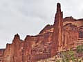
Distance: 1.8 - 4.4 miles (Round Trip)
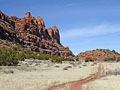
The Fisher Towers trail winds through stunning red rock towers shaped by erosional forces into impressive formations. Seldom does a short hike pack in such amazing views. Enroute visit the 900-ft. tall Titan, the U.S.’s largest free standing sandstone spire, soaring above the trail.
Distance: 1.8 - 2.3 miles (Round Trip)
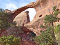
The broad, easy trail to Landscape Arch is popular and deservedly so. The spectacularly slender arch seeming defies gravity with its thinnest section, only 6-ft. thick, supporting a span of entrada sandstone that is 290-ft. long.
Distance: 9.6 miles (Round Trip)
The Murphy Trail is one of my favorite hikes in the Island in the Sky District of Canyonlands National Park with far reaching views of the vast landscape to the south and west of the Island in the Sky plateau.
Distance: 3.0 - 7.6 miles (Round Trip)
This beautiful hike traveling up the South Fork of Mill Creek features soaring sandstone walls, rock art and a perennial stream with lovely cascades and large pools. The South Fork offers more solitude than its sibling the North Fork and is a more interesting hike.
Distance: 8.0 - 10.4 miles (Round Trip)
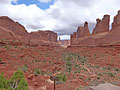
The Amasa Back trail offers a challenging, view packed hike to a ridge overlooking the Colorado River and the red rock country beyond.
Distance: 2.7 - 5.7 miles (Round Trip)
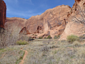
An off-the-beaten-path hike in the Klondike Bluffs area of Arches National Park leads through a secluded valley ringed by a wonderland of deep-red rock formations before reaching Tower Arch, an immense span with lovely views to the west.
Distance: 4.0 miles (Round Trip)
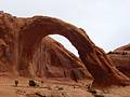
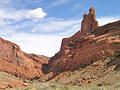
Wonderful views of a stunning canyon, solitude and an impressive jeep-shaped arch more than compensate for the difficulty in following a trail, which is poorly defined in places.
Dead Horse State Park Loop Trails ![]()
Distance: 2.0 - 6.6 miles (Loop)
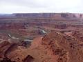
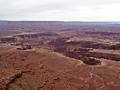
Amazing vistas of the sculpted canyons, pinnacles and buttes defining the landscape along the Colorado River and nearby Canyonlands National Park are the highlights of this easy 6.0 mile loop hike traveling around the southern end of Dead Horse State Park.
Distance: 2.0 miles (Round Trip)
Spectacular panoramic views of the red rock canyon between the Colorado and Green Rivers, the Needles and Maze Districts of Canyonlands National Park and beyond are the scenic rewards for this easy hike to the southern tip of the Island in the Sky mesa in Canyonlands National Park.
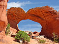
Distance: 0.6 miles (Loop)
A short, easy hike leads to a photogenic arch perched on a cliff edge with great views of the La Sal Mountains, Buck Canyon and Washer Woman Arch. This is a popular trail, especially with sunrise photographers.
Distance: 1.8 - 3.4 miles (Round Trip)
Looking for a short hike that is long on solitude and features scenic cliffs, rock art and views of the Colorado River? Then hike to Moki Mesa, situated atop a bench between the Colorado River and Poison Spider Mesa.
Distance: 0.6 - 1.7 miles (Round Trip)
A short hike leads to a fascinating viewpoint overlooking a geologic anomaly in canyon country where rock layers are dramatically deformed into a dome surrounded by a giant anticline, which looks like a crater measuring nearly 3-miles across.
Distance: 0.9 - 1.7 miles (Round Trip)
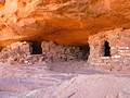
A steep climb up a slickrock dome leads to ancestral Puebloan granaries and outstanding views of Taylor Canyon.
Sand Dune, Broken and Tapestry Arches Loop ![]()
Distance: 1.6 - 2.7 miles (Loop)
This moderately-easy family hike visits three interesting arches; Sand Dune Arch, Broken Arch and Tapestry Arch, and travels through scenic desert landscape on uncrowded trails, a rarity in Arches National Park.
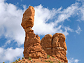
Distance: 0.3 miles (Round Trip)
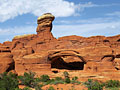
The Balanced Rock trail circles a photogenic 128-ft. tall rock formation, offering a variety of perspectives of the formation and the surrounding landscape in Arches National Park.
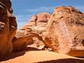
Distance: 0.3 miles (Round Trip)
A short hike to a secluded arch nestled among sandstone fins, south of the Devil’s Garden section of Arches National Park.
Distance: 0.4 miles (Round Trip)
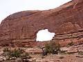
Distinctive Skyline Arch graces the top of a large fin and is visible from many viewpoints around Arches National Park. A short, easy trail leading to the base of the arch provides up-close views of this impressive span.
View Hikes by Area:
Southeast UtahArchesCanyonlandsMoabGrand GulchBears Ears NMNatural Bridges NMBluff