Best Hikes in Scuol
Location: Eastern Switzerland
Scuol Hiking Trails
Distance: 7.3 - 9.2 miles (Loop)
Difficulty: moderate-strenuous
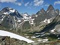
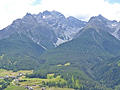
This loop hike ascends thorough lovely meadows to the overlook at Mout da l’Hom and then the summit of Piz Clunas with panoramic views of the high peaks towering above the Lower Engadine Valley and beyond.
Distance: 6.8 - 10.4 miles (One Way)
Difficulty: moderate-strenuous
Panoramic views of rugged peaks, two beautiful valleys and a chance to see wildlife are the scenic rewards of this great hike, one of the best in the Swiss National Park, visiting Val Minger and Val Plavna.
Distance: 7.0 - 8.0 miles (One Way)
Difficulty: moderate-strenuous
The Munt la Schera trail, in the Biosfera Val Mustair and the Swiss National Park, ascends through scenic meadows sprinkled with wildflowers to the broad summit of Munt la Schera where panoramic views extending to the summits in the Swiss National Park, Italy’s Stelvio National Park and beyond.
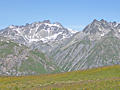
Guarda to Ardez via Furcletta Pass ![]()
Distance: 9.0 - 13.5 miles (One Way)
Difficulty: strenuous
This long, demanding hike visits three scenic valleys and crosses a panoramic pass with splendid views of the high peaks of the Silveretta and Engadine Dolomite Alps.
Distance: 12.0 - 12.7 miles (Round Trip)
Difficulty: strenuous
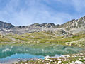
This trail ascends the Zeznina Valley to the gorgeous Macun Lakes in the Swiss National Park. The glacial lake basin lies nestled beneath a rugged cirque high above the Lower Engadine Valley. Extend the hike with a challenging climb to the Baselgia Ridge and a very steep descent to Zernez.
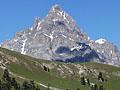
Val Sesvenna and Fuorcla Sesvenna ![]()
Distance: 8.6 - 10.2 miles (Round Trip)
Difficulty: moderate-strenuous
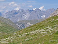
Ascend the Sesvenna Valley to a rocky, meadow-clad bowl accompanied by fine views of the peaks and summits rising to the west. Extend the hike with a very steep climb to Sesvenna Pass with stunning vistas of the rugged Sesvenna cirque and the summits towering above the S-charl Valley, the Swiss-Italian border and beyond.
Distance: 12.4 miles (Round Trip)
Difficulty: moderate-strenuous
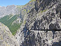
This trail, popular with hikers and mountain bikers, ascends through forest and then the meadows of Alp Dadaint before traveling through the dramatic Uina Gorge, a narrow chasm between two sheer rock walls.
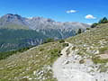
Distance: 6.8 - 9.4 miles (One Way)
Difficulty: moderate
This scenic traverse along the north side of the Lower Engadine Valley combines great views of the valley's high peaks with lovely rambles through pretty villages with traditional Engadine homes decorated with sgraffiti.
Distance: 6.8 - 8.4 miles (One Way)
Difficulty: moderate
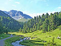
Forested slopes, expansive meadows and the pretty Clemgia River, meandering down a scenic valley beneath rugged peaks and rounded mountains, are the hallmarks of this hike up the S-charl Valley to Fuorcla Funtana da S-charl, a broad pass overlooking the S-charl and Mustair Valleys. End the hike by descending into the Mustair Valley to Ofenpass (Pass dal Fuorn in Romansh).
View Hikes by Area:
Eastern SwitzerlandSt MoritzScuolDavos
| Support our Site |