Best Hikes in Bluff, Utah
Location: Southeast Utah
On UT-191, 100 miles south of Moab, UT and 120 miles west of Durango, CO
By: Diane Greer
Bluff Hiking Trails
Distance: 2.8 miles (Round Trip)
Difficulty: moderate
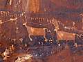
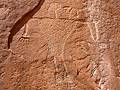
Without a doubt, my favorite rock art site along the Lower Butler Wash Road is the amazing Procession Panel, a 15-ft long petroglyph panel though to represent a ceremonial gathering or migration story.
Distance: 0.8 - 1.4 miles (Round Trip)
Difficulty: easy-moderate
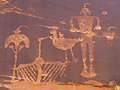
The Wolfman Panel is fascinating both for its precise artwork as well as its interesting figures. The easy access and short hiking distance make this site a popular spot for rock art enthusiasts passing through the Bluff and Mexican Hat area.
Distance: 2.1 miles (Round Trip)
Difficulty: easy
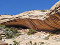
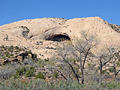
Explore a cave with the remains of a kiva and perennial spring along with a nearby alcove containing ruins and rock art on this easy hike up a short canyon off the Lower Butler Wash Road.
Distance: 1.6 miles (Round Trip)
Difficulty: easy
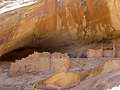
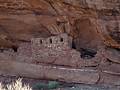
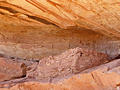
This short, easy trail leads to an impressive ruin situated in a deep, east facing alcove beneath a pour-off. The site, located in a side canyon off the Lower Butler Wash Road, includes an interesting structure with rounded walls along with rock art, pottery shards and grinding stones.
Distance: 3.6 - 8.0 miles (Round Trip)
Difficulty: easy-moderate
A moderately-easy hike up a pleasant, shallow canyon with Ancestral Puebloan ruins and a few rock art sites.
Distance: 3.0 - 5.4 miles (Round Trip)
Difficulty: easy-moderate
This short, moderately-easy hike leads to a stunning rock art panel along the north side of the San Juan River.
Distance: 1.9 miles (Round Trip)
Difficulty: easy-moderate
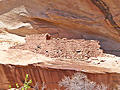
Four archaeology sites, some rock art and an impressive large and deep alcove lure hikers up a short, narrow canyon off the Lower Butler Wash Road.
Distance: 1.8 miles (Round Trip)
Difficulty: easy
Two alcoves, stacked one atop of the other, harbor interesting ruins and rock art in a canyon off the Lower Butler Wash Road.
Distance: 1.3 miles (Round Trip)
Difficulty: easy
Ruins, rock art and two sweat lodges are the highlights of this short hike in a brushy canyon to the west of the Lower Butler Wash Road.
View Hikes by Area:
Southeast UtahArchesCanyonlandsMoabGrand GulchBears Ears NMNatural Bridges NMBluff