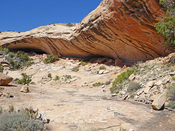
First views of the alcove and Cold Springs Cave
Explore a cave with the remains of a kiva and perennial spring along with a nearby alcove containing ruins and rock art on this easy hike up a short canyon off the Lower Butler Wash Road.
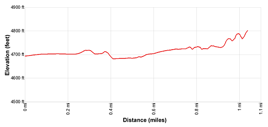
- Distance: 2.1 miles (RT)
- Elevation: 4,680-ft. at Trailhead
Maximum elevation - 4,800-ft. - Elevation Gain: 120-ft.
- Difficulty: easy
- Basecamp: Bluff / Bears Ears NM
- Region: Southeast Utah
Trail Description - Cold Springs Cave Ruin
Comb Ridge is a stunning sandstone ridge of steeply tilted rock layers called a Monocline, a step-like fold in the rock strata. The ridge runs north-south for approximately 80 miles from Utah’s Abajo Mountain to Kayenta, Arizona. The jagged appearance of the ridge is similar to a rooster’s comb, hence the name.
The Lower Butler Wash Road, paralleling the base of the ridge to the east, offers access to the ridge and its drainages renowned for prehistoric sites, including ruins and rock art. Cold Springs Cave is a highly recommended stop along the road.
The biggest challenge when visiting the sites along Butler Wash is finding the correct trailhead. There are no signs marking turnoffs to the various drainages. When looking for trailheads your best bet is to religiously keep track of your mileage as you progress up or down the road. (See the driving directions below for more information.)
The road to the Cold Springs Cave parking area is in very bad condition. Large gullies have opened up along the road making is very difficult, if not impossible to get to the original trailhead parking area. Your best bet is to drive about 120-ft. down the spur road to a wide spot along the road, aka the new parking area, and walk the rest of the way to the original parking spot. The easy walk will add 0.1 miles to the hike. The rest of this description assumes you park at the new area.
From the new parking area follow the washed out road 0.1 miles to the old parking area. Here mylar marks block cars from continuing along the road. The trail now crosses a deep gully sliced through the road and then heads west on the washed out remains of an old dirt two-track road.
At 0.2 miles the road briefly disappears as it crosses a washed out area. A boot beaten path should keep you on track. Past the wash out the trail curves right (northwest) and reaches Butler Wash at 0.4 miles.
Follow the trail as it crosses Butler Wash and then briefly travels above a side wash. At 0.5 miles the trail turns left, crosses the side wash and soon enters a canyon.
Reach a small pool at the base of a low pour-off at 0.9 miles. Here the canyon splits. Take the right fork, ascending the boot beaten path along the left side of the pour-off. At 1.0 miles views open to a long overhang/alcove along the right (north) side of the canyon and a cave at the head of the canyon. The alcove and the cave harbor ruins, rock art and grinding stones.
When visiting the ruins in Cold Springs Cave please treat all the archaeology you discover with reverence and respect so that it may be enjoyed by future generations. Do not sit, climb or step on the walls of any structures or attempt to enter the structures. Leave any pot shards, corn cobs or other relics where you found them. Remember that rock art is extremely fragile and easily damaged. Never touch rock panels as the oil on your fingers can speed the erosion of the rock art. Do not vandalize the panels by taking latex mold prints or rubbings from rock art or adding modern additions. Please see the Tips for Enjoying and Preserving Archaeology Sites for more information.
Numerous structures in various states of decay are located along the length of this long, shallow alcove. Red and white handprints and a variety of pictographs decorate the alcove’s wall above a small, partially reconstructed ruin. Rocks lying along the floor of the alcove were used as metates.
The cave features a kiva, the remains of several structures and numerous stones used for grinding. Look for petroglyphs pecked into the stones along the floor of the cave. You will also see a stone inscribed in 1892 that gives the site its name. A long wall across the back of the cave seems to block off or protect a small spring located along the cave’s back wall.
When you are done exploring the alcove and the cave retrace your steps to the trailhead for a 2.1 miles round-trip hike.
Elevation Profile
Driving Directions
The surface of Utah County Road 262, the Butler Wash Road, is packed dirt with sections of slickrock. The road can be rutted, sandy and rough in place. Under good conditions the road is passable with a 2WD vehicle if driven carefully. High clearance or 4WD is better.
From Bluff: Drive southwest on US-191 S for 4.2 miles. Where US-191 turns south continue straight ahead on US 162 for 0.9 miles and turn right on County Road 262 / Lower Butler Wash Road. The road is located between mile posts 41 and 40 and is across from the Bluff Airport Road (County Road 269A). Almost immediately reach a gate across the road, secured by a chain. Make sure you close the gate after passing through. At 7.4 miles reach a spur road on the left [~GPS location: 37.362637, -109.627440]. Turn left onto the spur and drive a short distance to a parking area. The last time I visited the area the road was in very bad condition forcing us to park before the standard parking area. It’s an easy walk to the end of the road so don’t chance getting your vehicle stuck.
From Mexican Hat: Drive east on US-163 for 19.6 miles and turn left on County Road 262 / Lower Butler Wash Road. The road is located between mile posts 41 and 40 and is across from the Bluff Airport Road (County Road 269A). Almost immediately reach a gate across the road, secured by a chain. Make sure you close the gate after passing through. At 7.4 miles reach a spur road on the left [~GPS location: 37.362637, -109.627440]. Turn left onto the spur and drive a short distance to a parking area. The last time I visited the area the road was in very bad condition forcing us to park before the standard parking area. It’s an easy walk to the end of the road so don’t chance getting your vehicle stuck.
Trail Resources
- Trail Photo Gallery
- Trail Maps
- Basecamp(s) Information: Bluff / Bears Ears NM
- Region Information: Southeast Utah
- Other Hiking Regions in: Utah