Aztec Butte 
Distance: 0.9 - 1.7 miles (round trip)
Island in the Sky District, Canyonlands National Park, near Canyonlands in Southeast Utah
By: Diane Greer
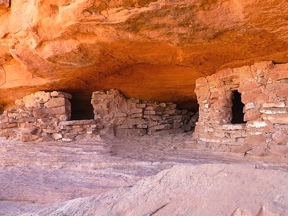
Two granaries beneath a ledge on the Aztec Butte trail.
A steep climb up a slickrock dome leads to ancestral Puebloan granaries and outstanding views of Taylor Canyon.
See Trail Detail/Full Description
- Distance: 1.7 miles (round trip)
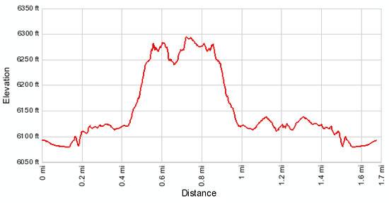
- Elevation: 6,095-ft. at Trailhead
Maximum elevation: 6,300-ft. - Elevation Gain: 205-ft.
- Difficulty: moderate
- More Hikes in:
Canyonlands / Moab / Southeast Utah
Why Hike Aztec Butte
The short, steep climb up scenic Aztec Butte leads to interesting ancient Pueblo granaries tucked into alcoves beneath the butte’s north rim and expansive views of Trail Canyon, the Island in the Sky mesa and beyond. On the return a spur trail ascends a smaller sandstone dome and visits two more granaries.
The trail to the top of Aztec Butte is steep and includes some difficult sections. Hikers should be comfortable ascending steep slickrock pitches and scrambling up and down ledges with some exposure. This trail is not recommended for anyone with a fear of heights.
The trail climbing the smaller dome is a good alternative for hikers looking for a shorter and easier hike.
Elevation Profile
Trail Resources
Trail Detail/Full Description / Trail Photo Gallery / Trail Map
Basecamp(s) Information:
Canyonlands / Moab
Region Information:
Southeast Utah
Other Hiking Regions in:
Utah