Details: Bridge of Heaven (via the Horsethief Trail) 
Distance: 8.0 miles (round trip)
Uncompahgre National Forest, near Ouray in Southwest Colorado
By: Diane Greer
Hike Facts
- Distance: 8.0 miles (round trip)
- Elevation: 9,300-ft. - 12,300-ft.
- Elevation Gain: 3,000-ft.
- Difficulty: strenuous
- Trail Highlights: See Trail Intro
- Basecamp(s): Ouray
- Region: Southwest Colorado
This well-engineered trail ascends 3,000-ft. to a knife-edge ridge with spectacular panoramic views.
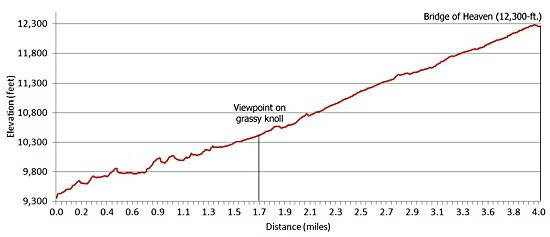
Trailhead to First Viewpoint
Distance from Trailhead: 3.4 miles (round trip)
Ending/Highest Elevation: 10,385-ft.
Elevation Gain: 1,085-ft.
From the trailhead parking area (see driving directions), walk about 100 yards up the road to the Horsethief trailhead on the right (south side) of the road. The trail immediately starts uphill on a series of well graded switchbacks through a mixed forest of spruce and aspen. After ascending for about 15 minutes sporadic openings in the trees reveal views of Whitehouse Mountain to the west and Ridgway to the north.
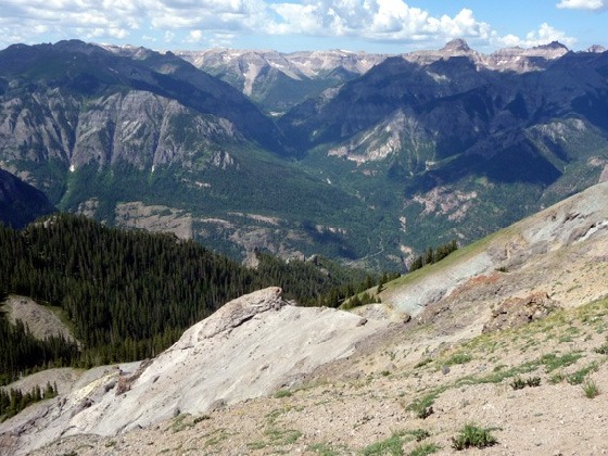
At 1.7 miles reach a marked trail junction on a grassy hillside with a sign pointing to a faint trail heading downhill toward Ouray. This is the old Horsethief trail that starts at the northern end of Ouray (the trail was repaired and rerouted in 2004). To the right of the junction is a grassy knoll with wonderful views of Yankee Boy Basin and prominent peaks of the Sneffels range across the valley to the west. To the south you can see the town of Ouray along with the peaks flanking the San Juan Skyway (aka the Million Dollar Highway) including Mt. Hayden, Mt. Abrams and, the aptly named, Red Mountain. The viewpoint is a good destination for people hiking with young children or hikers with limited time looking for a short hike with great views.
First Viewpoint to Bridge of Heaven
Distance from Trailhead: 8.0 miles (round trip)
Ending/Highest Elevation: 12,300-ft.
Elevation Gain: 3,000-ft.
The trail now travels on mostly open slopes along the south side of a ridge with nice views, passing in and out of isolated pockets of trees. Along the way a few switchbacks ease the ascent. For a brief period the trail crosses to the north side of the ridge revealing the highly eroded hillsides of the Dexter Creek drainage and the western most peaks of the Cimarron range to the northeast, including distinctive Courthouse Mountain.
At 3.5 miles the trail breaks out of the trees for the last time, crosses a small depression and then begins climbing a series of steep switchbacks up a grassy hillside. Expansive and ever improving views of the Cimarron Range, the Sneffels Range, Ironton and the Red Mountain Pass area divert your attention from the stiff climb.
At the top of the hill follow the trail a short distance to a wooden stake marking the Bridge of Heaven, a narrow 20-ft.-long section of the ridge, at 12,300-ft. To get the best views from this amazing vantage point take a short side trip up the dirt knoll on the west side of the Bridge.
From the knoll the magnificent panorama of the Sneffels range and the peaks forming the south and western walls of Yankee Boy Basin fill the skyline to the west. To the south views extends along the San Juan Skyway from Mt. Hayden to the Red Mountains. To the northeast the sculpted peaks of the Cimarron range paint the horizon. To the north is the town of Ridgway. Keep an eye out for bighorn sheep on the rocky ridges below the Bridge.
Across the Bridge to the east the Horsethief trail drops down into a grassy bowl and then continues its southeastern course towards Difficulty and American Flats. These destinations are beyond the range of a day hike.
After soaking in the scenery retrace your footsteps. The well maintained trail makes it easy to enjoy the views all over again on the descent.
Elevation Profile
| Buy the BookThis opinionated guide includes all the hikes in the Ouray, Telluride, Silverton and Lake City sections of the website plus info on local services and nearby attractions. |
Driving Directions
Driving directions from Ouray: Drive 2.0 miles north from the center Ouray on Highway 550 to County Road 14 and turn right. A sign at the turnoff points to the Bachelor-Syracuse Mine tours. Follow County Road 14, a good gravel road, for 1.0 mile as is winds its way past Lake Lenore and reaches the junction with County Road 14A. Stay on County Road 14 by bearing right at this junction. (CR-14A goes left.) CR-14 continues for 1.5 miles until it reaches a ford with Dexter Creek. (Note: you will first cross Dexter Creek on a bridge at .7 miles. Beyond this point the road becomes a bit rougher). Passenger cars should not ford the creek but instead find parking near the Dexter Creek trailhead, located right before the ford. (Parking before the ford will add 2.2 miles round trip and over 700-ft. of climbing to the hike.)
If you have a 4WD cross the creek and continue up the road for another 1.1 miles to the trailhead parking area on the left. The parking lot is an open area with piles of rock from the Wedge mine. (Note: Please respect the private property on both signs of the road.) The trailhead is located about 100 yards up the road on the right (south). If it is not possible to park at the Wedge Mine continue up the road a short distance (past the trailhead) to an open field and park.
Trail Resources
Trail Intro / Trail Photo Gallery / Trail Map
Basecamp(s) Information:
Ouray
Region Information:
Southwest Colorado
Other Hiking Regions in:
Colorado