Details: Porphyry Basin 
Distance: 5.0 - 7.0 miles (round trip)
Uncompahgre National Forest, near Silverton in Southwest Colorado
By: Diane Greer
Hike Facts
- Distance: 5.0 - 7.0 miles (round trip)
- Elevation: 11,230-ft. - 12,800-ft.
- Elevation Gain: 1,340-ft. - 1,660-ft.
- Difficulty: moderate
- Trail Highlights: See Trail Intro
- Basecamp(s): Silverton / Ouray
- Region: Southwest Colorado
This scenic hike climbs to two pretty lakes in gorgeous Porphyry Basin. Along the way the trail travels through wildflower-filled meadows and passes waterfalls, interesting rock formations and mining ruins. The lovely alpine meadows of the upper basin offer several options for off-trail exploration.
Trailhead to Bullion King Lake
Distance from Trailhead: 5.0 miles (round trip)
Ending/Highest Elevation: 12,570-ft.
Elevation Gain: 1,340-ft.
Note: This hiking description starts at the first parking area (see driving directions below) since it allows for a longer walk. If you prefer to continue driving up the dirt road to the second parking area, subtract one mile from the one way distances listed in the description below.
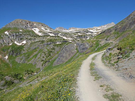
From the first parking area follow the jeep road as it climbs on moderately-easy grades up the hillside along the north side of Porphyry Gulch. Along the way enjoy views that extend south toward Bear (12,987-ft.), Sultan (13,368-ft.) and Anvil (12,537-ft.) mountains. McMillian Peak (12,804-ft.) and Red Mountain massif (12,890-ft.) rise above the Mineral Creek valley to the east. As you gain height, the summits of the high peaks in the Uncompahgre Wilderness appear above the sea of peaks and ridges to the northeast.
Pass two jeep roads branching to the right at 0.6 miles and 1.0 mile. Both roads lead to the Bear Basin road to the north. You will now see a few places to park off the road. This is the second parking area described in the “Driving Directions” below.
At 1.1 miles the road turns sharply to the left (west/southwest) and passes a sign warning of the rough and dangerous road ahead. Here the road narrows and starts climbing along a narrow, rocky shelf with steep drop-offs.
Soon the road rounds a bend and gorgeous Porphyry Basin springs into view. Three Needles (13,481-ft.) and Peak 13375 form the backdrop for basin to the west. Meadows sprinkled with wildflowers grow amid rock outcroppings and walls that define the basin’s three levels. Waterfalls cascade down crevasses and over rock walls into Porphyry Gulch below the trail. The high peaks of the Grenadier Range rise in the distance to the southeast.
The grade abates briefly as the road crosses a slide area and then continues climbing the scenic basin. In season the slopes along both sides of the road are clad in wildflower-filled meadows.
At 1.8 miles the wood remains of an old mining structure appear to the left (south) of the road. Soon the road crosses a creek and curves to the left (south) near a very large tailings pile. Walk through a parking area used by high clearance, 4WD vehicles. Past this point the road is closed to vehicular traffic. At the south end of the parking area a hillside covered in dirt now blocks the road. This is the site of mine waste repository constructed as part of a 2015 mine reclamation project.
Walk straight ahead (south) across the dirt hillside to the continuation of the old mining road, marked by a row of boulders, and follow the road as it ascends south on easy grades. At 2.1 miles the road curves to the left (east) and crosses a stream.
Beyond the stream the road/trail climbs a series of switchbacks on moderate grades. At the top of the switchbacks is a large boulder with an old sign indicating where vehicles had to stop prior to the reclamation project. Skirt the boulder and follow the old road, which is faint in spots, as it swings right (west) and ascends to the middle basin, passing a small tarn along the way.
Reach Bullion King Lake (12,570-ft.) at 2.5 miles. The west side of this pretty lake is ringed by rugged cliffs. A waterfall, which can’t be seen from the southeast end of the lake, tumbles down a crevasse in the cliff face. Three Needles, Peak 13,375 and the rugged ridge between the two peaks tower above the lake to the west.
The lake is a great spot to take a break and laze in the sun. When you are done enjoying the lake either return to the trailhead for a 5.0 mile round trip hike or continue to Porphyry Lake. If time and energy permit, I strongly suggest hiking to the Porphyry Lake and exploring the upper basin.
To Porphyry Lake
Distance from Trailhead: 6.4 miles (round trip)
Ending/Highest Elevation: 12,800-ft.
Elevation Gain: 1,570-ft.
To find the trail to Porphyry Lake, cross Bullion King’s outlet stream (the South Fork of Porphyry Creek) and then walk east along the north side of the stream for about 130-ft. A wide point on the outlet stream marks where the old mining road crosses the creek. Look left (north) across the meadows. You should be able to see faint vehicle tracks climbing the right (northeast) side of the bench rising to the north of the lake. Walk north across the meadows to where you can see the tracks and then climb on moderately steep grades up the vehicle track to the top of the bench. As you crest the bench (2.7 miles) the grade abates and the trail curves to the left (west/northwest).
Snow cover may make seeing/finding the old road difficult. If snow is covering the trail, walk north across the meadows and then climb up the northeast end of the bench. At the top of the bench you should be able to see vestiges of the old track.
Continue following the old vehicle tracks across the bench on easy grades. At 2.8 mile the tracks curves to the left (south/southwest) and crosses a stream. The vehicle tracks are faint just before the crossing. This area is often covered in snow early in the season, which complicates route finding. On the other side of the creek the tracks, which head south/southwest are easier to follow.
Soon the old road curves to the right (west/northwest) and soon arrives at a small tailings pile and the ruins of a wooden structure at 3.0 miles. This is the site of the Porphyry Mine. Here the old road ends. After exploring the area around the mine walk west/southwest to a pretty, unnamed lake (12,760-ft.) located a short distance from the mine.
To reach Porphyry Lake walk to inlet stream at the north end of the unnamed lake and follow the stream uphill (northwest), staying on the right (east) side of the stream. Note: there may not be any water in the stream but the stream course is evident, a small gully running between two low hills. As the stream bed peters out continue climbing northwest. You will soon crest a hill and see beautiful Porphyry Lake (12,800-ft.) nestled in a bowl beneath Three Needles. The distance from the mine to Porphyry Lake is just under 0.2 miles.
From the lake you can either retrace your steps to Bullion King Lake (11,230-ft.) and the trailhead for a 6.4 miles round trip hike or extend the hike by trying one of the off trail options listed below.
Side Trip to South Ridge Overlook
Distance from Trailhead: 7.0 miles (round trip)
Ending/Highest Elevation: 12,890-ft.
Elevation Gain: 1,660-ft.
The easiest option for extending your hike is to climb the ridge rimming the south side of Porphyry Basin. To reach the ridge from Porphyry Lake, retrace your steps to the unnamed lake and then walk south along the lake’s east shore. At the south end of the unnamed lake rock hop across a stream and then start climbing up a rocky slope, heading for the grassy slopes leading to the top of the ridge. You will pass a small lake on your left (east) as you start the climb.
The climb from the south end of the unnamed lake to the top of the ridge will gain about 135-ft. in less than 0.2 miles. From the top of the ridge enjoy terrific views of the sea of peaks extending from the Needles in the Grenadier Range to the southeast to the high peaks of the Uncompahgre wilderness to the northeast. Total distance from Porphyry Lake to the top of the ridge is 0.6 miles.
Side Trips to Mud and Blue Lake Overlooks
Distance from Trailhead: 7.2 miles (round trip)
Ending/Highest Elevation: 13,260-ft.
Elevation Gain: 2,030-ft.
Mud Lake Overlook: Looking north from Porphyry Lake you will see a saddle on the low point of the ridge extending northeast from Three Needles to Peak 13477. This is what I will call the Mud Lake Overlook. A snow cornice often last well into the season atop the saddle.
To reach the saddle walk around the east side of Porphyry Lake and then pick the route of least resistance to climb the talus slopes up to the saddle. Skirt the snow cornice, if present, to the left. The scenic saddle (12,960-ft.) is about 0.35 miles from the lake and overlooks Mud Lake and the Mud Lake Basin. In the distance to the northwest are nice views of the peaks rising above the north side of the Telluride Valley. La Junta peaks towers above the west side of Bridal Veil Basin.
Distance from Porphyry Lake to Mud Lake Overlook: 0.35 miles (one-way) / 0.7 miles (round trip)
Distance from Trailhead: 7.1 miles (round trip)
Ending/Highest Elevation: 12,960-ft.
Elevation Gain From Porphryr Lake: 160-ft.
Elevation Gain from Trailhead: 1,730-ft.
Blue Lake Overlook: To the west of Porphyry Lake is a small saddle on the ridge running south from Three Needles. This is a much steeper and more difficult climb than the Mud Lake Overlook. I only recommend this option for experienced, well acclimated hikers who are comfortable climbing steep talus slopes. It is not a good option is snow covers the route.
To reach the saddle, skirt the south side of Porphyry Lake and the start climbing the steep grassy slopes beneath the saddle. About two-thirds of the way up the grass gives way to talus. This is a hard climb for most people. Members of your party may be uncomfortable with the steep pitch. I strongly recommend trekking poles on the descent.
Hikers reaching the saddle (13,260-ft.) are rewarded with great views of Blue Lake in Bridal Veil’s East Basin. La Junta Peak rises beyond the basin to the west while the peaks towering above Telluride fill the skyline to the northwest
Distance from Porphyry Lake to Blue Lake Overlook: 0.4 miles (one-way) / 0.8 miles (round trip)
Distance from Trailhead: 7.2 miles
Ending/Highest Elevation: 13,260-ft.
Elevation Gain from Porphyry Lake: 460-ft.
Elevation Gain from Trailhead: 2,030-ft.
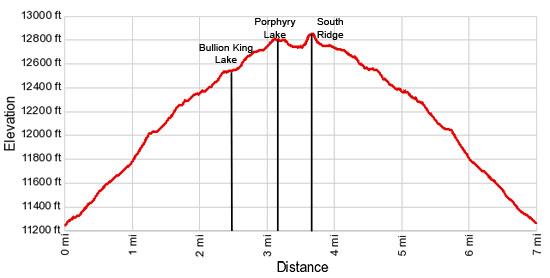
Elevation Profile
| Buy the BookThis opinionated guide includes all the hikes in the Ouray, Telluride, Silverton and Lake City sections of the website plus info on local services and nearby attractions. |
Driving Directions
Driving directions from Silverton: From the intersection of Main Street and US 550 in Silverton, head north on US 550 N for 9.1 miles and turn left (west) on Forest Service Road 822. You can’t see the road number from the highway but you will pass a marker a short distance up the road. (Passenger cars should find a pull off along the highway for parking.)
The beginning of the road is narrow and steep to the first parking area. Some of the switchbacks are rocky and rugged. You will need an AWD SUV/4WD with good clearance. Beyond that point the road gets rougher to the second recommended parking area. Past this point there was a sign warning of a rough and dangerous road ahead. The sign is now gone. This section of the road travels along a very narrow shelf with steep drop-offs and a few rock outcroppings to climb. Passing another car along this road segment is not an option.
To reach the first parking area drive up the road for 0.7 miles. Before coming to the end of the first switchback you will see a road branching left (south) that leads to a house. Ignore this road and continue up a series of switchbacks, passing a second road branching left (south) to a second house at the top of the fifth switchback. Beyond this point you will soon see a good parking area on the left (south) side of the road below a cluster of trees. This is the first parking area, recommended for people looking for a longer walk or drivers that don’t feel comfortable proceeding further up the road.
To reach the second parking area, continue up the road another mile, passing two roads branching right. Between the second road and a cluster of spruce trees you will find several places to park. This is the second parking area, located 1.7 miles from US 550.
High clearance, 4WD vehicles and OHV's can continue beyond this point for another 0.9 miles to a parking area at the end of the road near mining debris and a huge mound of mine tailings.
Driving directions from Ouray: From Main Street and 6th Avenue in Ouray, drive 13 miles south on US 550 to Red Mountain Pass. Proceed down the south side of the pass for 0.7 miles and turn right (west) on Forest Service Road 822. This will be the first right turn after you pass the road to Black Bear Pass (FSR 823) on the right. You can’t see the road number from the highway but you will pass a marker a short distance up the road to verify you are in the right track. (Passenger cars should find a pull off along the highway for parking.)
The beginning of the road is narrow and steep to the first parking area. Some of the switchbacks are rocky and rugged. You will need an AWD SUV/4WD with good clearance. Beyond that point the road gets rougher to the second recommended parking area. Past this point there was a sign warning of a rough and dangerous road ahead. The sign is now gone. This section of the road travels along a very narrow shelf with steep drop-offs and a few rock outcroppings to climb. Passing another car along this road segment is not an option.
To reach the first parking area drive up the road for 0.7 miles. Before coming to the end of the first switchback you will see a road branching left (south) that leads to a house. Ignore this road and continue up a series of switchbacks, passing a second road branching left (south) to a second house at the top of the fifth switchback. Beyond this point you will soon see a good parking area on the left (south) side of the road beneath a cluster of trees. This is the first parking area, recommended for people looking for a longer walk or drivers that don’t feel comfortable proceeding further up the road.
To reach the second parking area, continue up the road another mile, passing two roads branching right. Between the second road and a cluster of spruce trees you will find several places to park. This is the second parking area, located 1.7 miles from US 550.
High clearance, 4WD vehicles and OHV's can continue beyond this point for another 0.9 miles to a parking area at the end of the road near mining debris and a huge mound of mine tailings.
Trail Resources
Trail Intro / Trail Photo Gallery / Trail Map
Basecamp(s) Information:
Silverton / Ouray
Region Information:
Southwest Colorado
Other Hiking Regions in:
Colorado