Sefinenfurgge Pass 
Distance: 8.4 - 12.0 miles (round trip)
Bernese Oberland, near Lauterbrunnen in The Bernese Oberland
By: Diane Greer
This beautiful walk showcases the high peaks soaring above the Lauterbrunnen and Sefinen valleys. The trail ascends through pretty meadows with nonstop views to Rotstock Hut and then climbs a wild valley to the Sefinenfurgge Pass where vistas open to the Kiental valley and beyond.
See Trail Detail/Full Description
- Distance: 8.4 miles (round trip) to Rotstock Hut
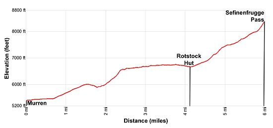
12.0 miles (round trip) to Sefinenfurgge Pass - Elevation: 5,374-ft. at Trailhead
6,700-ft. at Rotstock Hut
8,570-ft. at Sefinenfurgge Pass - Elevation Gain: 1,326-ft. to Rotstock Hut
3,196-ft. to Sefinenfurgge Pass - Difficulty: strenuous
- More Hikes in:
Lauterbrunnen / The Bernese Oberland
Why Hike Sefinenfurgge Pass
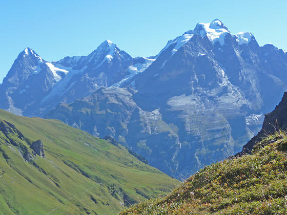
The trail to Sefinenfurgge Pass, the second highest pass on the Alpine Pass Route, traverses lovely meadows with breathtaking views of the high peaks towering above the Lauterbrunnen and Sefinen Valleys. The big three, the Eiger, Monch and Jungfrau, are your constant companion through much of the hike.
Along the way the trail crosses a high ridge and enters the Sefinen Valley where the Tschingelspitz, the Gspaltenhorn and Butlasse are the stars of the show. An ascending traverse along the north side of the valley leads to the Rotstock Hut, set atop a grassy knoll with splendid views of the surrounding summits. The hut is a good turnaround point for parties looking for a shorter day (8.4 miles round-trip).
Beyond the hut the trail climbs steeply through rocky meadows and then scree covered slopes to the Sefinenfurgge Pass (8,570-ft.), a small notch on a knife-edge ridge. Here new vistas open to the Armighorn and Dundenhorn rising above the west side of the Kiental Valley. Looking south the Bluemlisalp massif rises above a low ridge. On a sunny day the ridge is a wonderful place to picnic while enjoying the panoramic views before retracing your steps to the trailhead.
The trail continues over the pass toward Griesalp, a stop on the Alpine Pass Route. See the Lauterbrunnen/Murren to Griesalp via the Sefinenfurgge trail description for more information.
Elevation Profile

Support our Site | |
Trail Resources
Trail Detail/Full Description / Trail Photo Gallery / Trail Map
Basecamp(s) Information:
Lauterbrunnen
Region Information:
The Bernese Oberland
Other Hiking Regions in:
Switzerland

