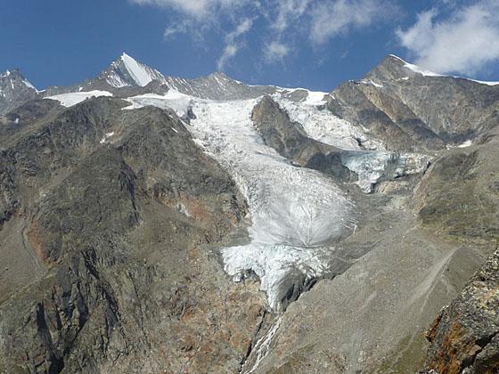
Two lofty overlooks offer impressive bird’s-eye views of the glacial cirque surrounding Saas Fee, the Hohblam Glacier and the Fletschhorn-Weissmies group. The return to Saas Fee features views of the Bider Glacier and a walk through a pretty forest.
See Trail Detail/Full Description
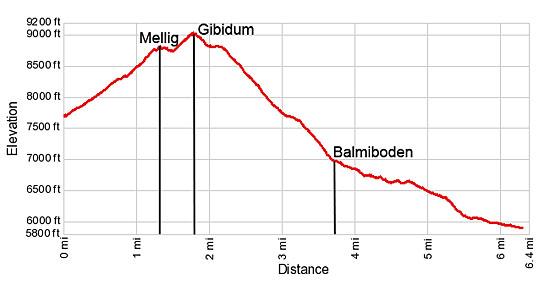
- Distance: 6.4 miles (loop)
- Elevation: 7,685-ft. at Trailhead
Maximum elevation: 9,027-ft. - Elevation Gain: 1,342-ft.
- Difficulty: moderate-strenuous
- More Hikes in:
Saas Fee / The Valais
Why Hike Mellig, Gibidum and the Bider Glacier
This hike visits two lofty viewpoints, Mellig and Gibidum, high above the northwest side of Saas Fee. The overlooks feature stunning, panoramic views of the dramatic cirque of 13,000-ft. (4,000-meter) peaks, adorn with glaciers and waterfalls, towering above the village. Above the viewpoints, the Hohbalm Glacier spills down the rugged flanks of the cirque formed by Lenzspitze, the Nadelhorn and Ulrichshorn. Across the Saas Valley to the east, the Fletschhorn, Lagginhorn and Weissmies dominate the view while distant views extend north to the Bernese Alps rising above the Rhone Valley.
Beyond the overlooks the trail drops down to Balmiboden, enjoying fine views of the Bidergletscher (Bider Glacier) cradled along the slopes of the Gemshorn and the southeast face of Balfrin. The trail then turns southeast, descending along forested slopes to Saas Fee.
Shorter versions of the hike visit one or both of the viewpoints before returning the Hannigalp. These options are great, albeit steep, hikes for anyone looking for a nice half day walk.
(Note: Mellig is spelled as Mallig on some maps. You may also see Gibidum spelled as Gebidum. For purposes of this description, I have used the spellings on the trail signs.)
Elevation Profile

Support our Site | |
Trail Resources
Trail Detail/Full Description / Trail Photo Gallery / Trail Map
Basecamp(s) Information:
Saas Fee
Region Information:
The Valais
Other Hiking Regions in:
Switzerland

