Details: Grachen to Saas Fee (Hohenweg Saas Fee) 
Distance: 10.8 miles (one way)
near Saas Fee in The Valais
Hike Facts
- Distance: 10.8 miles (one way)
- Elevation: 6,973-ft. - 7,945-ft.
- Elevation Gain: 1,980-ft.
- Difficulty: strenuous
- Trail Highlights: See Trail Intro
- Basecamp(s): Saas Fee / Zermatt
- Region: The Valais
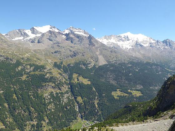
The Saas Fee Hohenweg is one of the classic hikes in the Valais. The challenging trail follows a high route along the west side of the Saastal with stunning, nonstop views of the glacier-clad peaks towering above the Saas Valley and the Bernese Alps to the north.
Saas Fee from Grachen along the Hohenweg Saas Fee
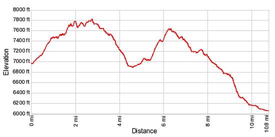
Note: Due to the up and down nature of the trail, the elevation gain and loss is much greater than it appears by simply looking at the trailhead elevation and the high point on the hike.
In Grachen take the Hannigbahn lift, a gondola located a short distance to the northeast of the post office bus stop, to Hannigalp (6,960-ft.). (See trailhead directions below.) Given the length and strenuous nature of this walk it is definitely worth the cost of the lift to avoid the 1.5 mile hike to Hannigalp, which climbs 1,640-ft. through forest with limited views. Hikers taking the lift will also get an earlier start on what will be a long day.
At the top of the lift enjoy nice views of the Weisshorn to the southwest and the Beitschhorn, the prominent pyramid-shaped peak, in the Bernese Alps to the north. Find the signpost near the lift station and walk northeast on a broad track signed for Sass Fee (6-hr 35-min). The trail ascends a hillside on moderate grades, passes a small chapel and then curves to the east, entering a wooded area of larches and pines.
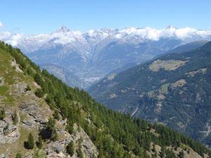
As the path rounds the head of the valley it curves to the south and briefly descends as it starts up the Saastal (Saas Valley). Openings in the trees reveal nice views of the peaks towering above the Rhone Valley to the north. To the southeast, the Fletschhorn, Lagginhorn and Weissmies, rising along the east side of the Saastal, dominate the view.
Signs along the path point toward Saas Fee or Hohenweg Saas Fee. Ignore trails branching right to Furggen / Wannehorn and left to a picnic table.
At 0.5 miles the trail starts a steep ascent. Over the course of the hike the trail will rise and fall to circumvent rock outcroppings and other obstacles, finding the path of least resistance as it traverses ridges and valleys along the valley’s steep hillsides.
Near the top of the climb the trail passes a second trail branching right to Fruggen / Wannehorn. Continue straight ahead toward Stock and Saas Fee. The grade abates at 0.9 miles and the trail now travels through an undulating landscape with great views of the Fletschhorn, Lagginhorn and Weissmies.
Near a gate at 1.4 miles fixed ropes provide handholds along an exposed section of the trail. Past the gate care should be used as the trail crosses a small rock slide.
Beyond the slide the narrow path, clinging to the hillside, climbs and descends steeply as it travels around two ridges beneath the Wannehorn. Fixed ropes and metal handrails attached to the rock face along sections of the rocky trail offer a level of security, especially if ice is present on the path. A short tunnel at 1.7 miles allows hikers to bypass a rock outcropping.
Reach Stock (7,775-ft.), a grassy overlook with wonderful views of the peaks towering above the Saastal, at 2.0 miles. A bench at the viewpoint provides a comfortable spot to rest and enjoy the panorama.
Beyond Stock the path drops steeply down a grassy hillside and then climb again as it passes beneath the Distelhorn. Soon the trail curves to the east, navigating a rocky cirque below the southeast ridge of the Seetalhorn. Exercise caution crossing an avalanche chute at 2.6 miles that is often wet and muddy.
As the trail crosses the Seetalhorn’s southeast ridge the grade eases and fine views reopen to the Saastal and the peaks towering above the Rhone Valley to the north. The path now descends on moderate grades through lovely meadows clinging to the steep hillside.
Reach Rote Biel (7,480-ft.), a popular overlook, at 3.6 miles. Here a sign (Schweibbach 20-min / Saas Fee 3-hr 40-min) points toward the continuation of our trail. Near the sign you may see vestiges of an old trail climbing the hillside. This trail, previously known as the Hohenweg Seetal, is now closed.
A short distance past the sign is a grassy knoll with wonderful views of Balfrin, the Lammerhorn and the Bigerhorn massif towering over the Balfrin Valley, a small side valley. The Balfrin Glacier spills down the flanks of the peaks while the tip of the Farichhorn rises above the head of the valley. Senggchuppa, the Fletschhorn, the Lagginhorn and the Weissmies fill the skyline to the southeast.
Beyond the overlook the trail descends southwest through larch and pine trees, crossing a few boulder fields along the way. The path loses almost 600-ft. as it drops to the floor of the Balfrin valley where it crosses a bridge over the Schweibbach stream.
Past the bridge the trail turns left (east) and ascends the slopes along the south side of the Balfrin valley on moderate grades that grow steeper as the path gains altitude. At 5.0 miles the trail enters the trees and curves to the south around the end of a ridge, returning to the Saastal Valley. For the next half mile the trail dips up and down as it travels beside a rock face high above the valley.
At 5.5 miles start a very steep climb up rocky meadows on an open slope with far reaching views of the Saas Valley and the peaks to the north. Reach Bockwang (7,411-ft.) at 5.9 miles where red and white blazes mark the best route through large rock slabs.
The trail drops briefly and then ascends across a large rockslide. Pay careful attention to the red/white blazes on the rocks to find the easiest route through the boulders.
Beyond the boulder field the narrow path climbs along a rock face. Fixed metal pipes and ropes bolted to the wall provide handholds along exposed section of the trail. A metal ladder at 6.3 miles facilitates the climb over a man-made rock wall intended to block livestock.
The trail now descends as it crosses a few small rockslides before curving around the end of a ridge to a great viewpoint at Lammugrabe (7,533-ft.) at 6.8 miles. From the overlook enjoy fine views of the Almagellerhorn, Stellihorn and the Egginer to the south. Saas Grund sprawls along the valley floor while Saas Fee lies nestled in a hanging valley along the west side of the valley. The Fletschhorn, Lagginhorn and Weissmies tower above the valley to the east. Signs at the overlook point toward Stafelalpji (25-min) and Saas Fee (2-hr).
The trail now drops through trees that give way to meadows where views open to the Bidergletscher (Bider Glacier) clinging to the western flanks of the Balfin. Cascades of melt water spill down the rocky hillside below the glacier.
Reach Stefelalpji (7,130-ft.) at 7.5 miles. Ignore signs pointing left (downhill) toward Bideralp, Saas Balen, Saas Grund and Saas Fee. Instead, continue straight ahead toward Balmiboden (30-min) and Saas Fee (1-hr 35-min).
After a brief ascent the trail resumes its descent, crossing several streams carrying glacial meltwater. At 7.9 miles the path reaches a large culvert going under a torrent of meltwater from the Bidergletscher. The trail actually goes through two culverts to safely bypass this obstacle. Signs nearby explain the construction of the culverts.
Shortly after passing through the culverts the trail enters the woods and starts descending toward Saas Fee, reaching Balmiboden (6,955-ft.) at 8.25 miles. Ignore the signs pointing toward Hannigbahn / Gibidum and Mellig. Instead continue in the direction of Saas Fee (1-hr 5-min).
Bear right toward Saas Fee at Senggboden, a small clearing at 8.7 miles. Soon you reach a second sign for Senggboden. We continue straight ahead to Saas Fee.
After a short uphill stint the trail drops steeply through trees. At the next sign there are two routes listed to Saas Fee. Avoid the route pointing right toward Hohnegg/Melchboden/Saas Fee and instead continue straight ahead following the sign only listing Saas Fee.
At Barenfalle (6,178-ft.), follow the trail toward the Saas Fee Post (30-min), which crosses a dirt road and then continues downhill, skirting a horse corral to join a broad dirt track. This track eventually turns into a wide dirt lane which goes by several exercise stations before coming to houses on the outskirts of Saas Fee.
At a “Y” intersection take the walkway marked as Carl Zuckmayer Weg that passes between two houses on the northern edge of Saas Fee. Walkways now head south toward downtown Saas Fee. When in doubt, walk in the direction of the signs pointing toward Dorfzentrum or the Tourist Information Bureau, which is located near the bus station. Reach the center of Saas Fee after walking 10.8 miles.
This hike can be done in reverse from Saas Fee to Grachen but includes an additional 1,000-ft in elevation gain. My recommendation is to do the hike in the Grachen to Saas Fee direction.
Note that there are no places to obtain food and drink along the route. Once on the trail there are very few places to “escape” to the valley if the weather turns foul. So pick a beautiful day, set out early, take plenty of food and water and enjoy this glorious high walk along the Saastal. It is one you will remember for a long time.
Elevation Profile
Driving Directions
From the Post Office in Grachen: Walk to the front of the post office/Kiosk. With your back to the post office turn right on the main street (Dorfweg) and walk a very short distance to a "Y" intersection. Bear right (east/northeast) up Barglistrasse. A sign at the corner points right toward the cable car station. You will be walking between the Haus Allain/Woodstock Restaurant (on the left) and the north side of the post office (on the right). Walk up the street for one block and turn right (south) on Spieli Strasse. The cable car station is clearly visible ahead. Walk up the street a short distance to the Hannig Cable Car Station on the left (north) side of the street. Signposts along the way will direct you to the Hannig lift.
From Saas Fee: Take Post Buses and a train to Grachen. From Saas Fee, board an early morning bus headed for Brig and get off at the Stalden-Saas Bahnhof (train station). At the train station catch a train heading for Zermatt and get off at the St. Niklaus station. At the St. Niklaus train station take the Post bus to Grachen, getting off at the Grachen Post stop. The entire trip takes 1-hour 40-minutes. You can buy a combined ticket to cover all the transportation at the bus station in Saas Fee. In Grachen, follow the directions above.
See the SBB website/SBB app for the schedule. Note: Grachen is spelled with an umlaut over the "a". On the SBB site enter Graechen. When you see the list of destinations select Grächen, post.
From St. Niklaus: Take the Post Bus to Grachen, getting off at the Grachen Post stop. In Grachen, follow the directions above.
From Zermatt: Take the train to St. Niklaus. Trains run every half hour and the trip takes about 36 minutes. In St. Niklaus catch the Post Bus to Grachen and get off at the Grachen Post stop. In Grachen, follow the directions above.
Note: Train and bus schedules are available online at the SBB website or the SBB app. Grachen is spelled with an umlaut over the "a". On the SBB site enter Graechen. When you see the list of destinations select Grächen, post.
Trail Resources
Trail Intro / Trail Photo Gallery / Trail Map
Basecamp(s) Information:
Saas Fee / Zermatt
Region Information:
The Valais
Other Hiking Regions in:
Switzerland