Backpack: New Fork to Island Lake and out Elkhart Park 
Distance: 45.7 miles (one way)
Bridger Wilderness, Bridger-Teton National Forest, near New Fork Lakes in Wyoming's Wind River Range
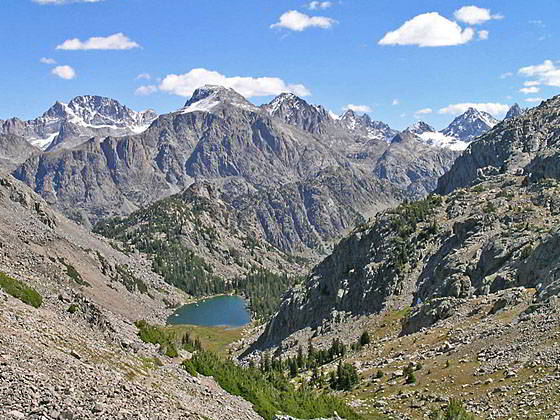
Clark Lake and the high peaks to the west
Towering granite walls, glorious alpine meadows, beautiful lakes and panoramic views of soaring peaks are the hallmarks of this terrific point-to-point backpack that follows the scenic New Fork and Highline trails to Island Lake. Return to civilization via the Seneca Lake and Pole Creek Trails to Elkhart Park.
- Distance: 45.7 miles
- Elevation: 7,895-ft. at New Fork Lakes Trailhead
7.825-ft. at Upper New Fork Lake
7,850-ft. at Junction Lowline/Doubletop Mtn. Trail
8,530-ft. at 1st New Fork River Crossing
8,640-ft. at 2nd River Crossing
8,880-ft. at Palmer Lake Junction
10,680-ft. at 1st Lozier Lakes Pass
10,940-ft. at 2nd Lozier Lakes Pass
10,270-ft. at Clark Lake
9,300-ft. at Junction Highline Trail at Trail Creek Park
9,640-ft. at Junction Shannon Pass Trail
10,390-ft. at Green River Pass
10,330-ft. at Junction Doubletop Mtn Trail at Summit Lake
10,880-ft. at Elbow Lake Basin Overlook
10,950-ft. at Junction Shannon Pass Trail
11,070-ft. at Divide
10,799-ft. at Upper Jean Lake
10,651-ft. at Lower Jean Lake
10,250-ft. at Fremont Crossing
10,550-ft. at Junction with Indian Pass Trail to Island Lake
10,410-ft. at Island Lake
10,400-ft. at Junction Seneca Lake Trail
10,300-ft. at Junction Pole Creek Trail
9,340-ft. at Elkhart Park Trailhead - Difficulty: strenuous
- More Hikes in:
New Fork Lakes / Elkhart Park / Wyoming's Wind River Range
Introduction
This point to point backpack visits some of the most dramatic landscapes in the northwestern Wind River Range. Typically backpackers visiting this section of the range start at the Green River Lakes trailhead. This backpack offers an alternative, less crowded entry point that avoids the long drive to Green River Lakes by starting at the New Fork Lakes trailhead.
The first segment of the backpack follows the New Fork Trail, which features dramatic views of the granite walls towering above New Fork Canyon and a delightful traverse of the beautiful meadows of New Fork Park. Beyond the Park the path climbs to the lovely Lozier Lakes Basin and crosses two passes with stunning, panoramic views of the northern Wind’s high peaks, including Gannett Peak (13,809-ft.) - Wyoming’s highest summit. After cresting the second pass the trail drops down to Clark Lake and then Trail Creek Park, where the backpack turns southbound on the Highline Trail.
Reaching the Highline via the New Fork trail is longer and gains more elevation than hiking the Highline to Trail Creek from the Green River Lakes Trailhead. In my opinion hikers are amply rewarded for the extra effort with great scenery along the New Fork Trail. Comparing the two starting points, the climb out of New Fork Park to the Lozier lakes gains over 2,350-ft and then loses over 1,200-ft. as it drops from the high point to Trail Creek Park. In contrast, following the Highline from Green River Lakes to Trail Creek Park is about 4 miles shorter and only gains 1,260-ft.
The next section of the backpack, traveling along the Highline to the junction with the Indian Pass Trail, features glorious alpine meadows, beautiful lakes and panoramic views of soaring peaks. From Trail Creek Park the Highline ascends to Summit Lake, crosses the Pine Creek drainage and then follows a rolling trail through lakes and tarns set amid meadows and timber clad knobs. Along the way the trail turns to the east and then northeast as it climbs to the magnificent Elbow Lake basin.
The trail through the basin, one of my favorite places in the Winds, stays well above timberline as it traverses small meadows growing amid ice-polish rock outcroppings and erratic boulders. Massive Elbow Lake, along with a collection of smaller lakes and tarns, lie nestled in rocky bowls.
Surrounding the basin is an amazing collection of high peaks. Bow Mountain (13,020-ft.), Mount Arrowhead (12,972-ft.), American Legion Peak (13,205-ft.) and Henderson Peak (13,115-ft.), along with the summits rising along the Continental Divide, dominate the view to the west. Mount Oeneis and Sky Pilot Peak tower above the basin to the north while Stroud Peak and Mount Whitecap rise to the northwest. Elbow Peak (11,948-ft.) fills the skyline to the south.
At the head of the basin the Highline ascends to a junction with the Shannon Pass Trail, branching left (northwest) to Shannon Pass and Peak Lake. A side trip to Peak Lake is highly recommended. To the left is the continuation of the southbound Highline Trail toward Fremont Crossing and Island Lake, considered by many to be the most scenic segments of the trail.
Starting at the head of the Elbow Lake Basin the Highline crosses a divide to the headwaters of Fremont Creek and then descends along Fremont Creek, passing the beautiful Jean Lakes along the way. The trail stays well above timberline, traveling through stunning alpine lakes basins set amid an incredible array of towering peaks.
Beyond Lower Jean Lake the trail drops down below timberline to Fremont Crossing and then follows an undulating course through meadows and scattered trees set amid rock outcroppings and granite knolls. Small tarns lie nestled in rocky bowls. The segment ends at the junction of the Highline trail with the Indian Pass trail. Here we turn left and follow the Indian Pass trail for a mile to breathtaking Island Lake.
Jaw-dropping panoramas, great hiking, good fishing and scenic campsites combine to make Island Lake one of the most popular destinations in the Wind River Range. If time and energy allow, plan a few layover days at Island Lake for day hiking. Favorite hikes in the area include the scenic trail to stunningly Titcomb Basin and the terrific walk to Indian Pass that climbs through the starkly beautiful Indian Basin. Parties looking for an easier day can wander around Island Lake, visiting waterfalls and the pretty lake basin to the northeast of the lake.
From Island Lake, the heavily trafficked exit route to Elkhart Park uses a combination of the Indian Pass, Highline, Seneca Lakes and Pole Creek Trails. Due to numerous ascents and descents, the 12.1 miles (one-way) route is more strenuous then the mileage and net elevation loss might imply. Some parties take two days to reach Elkhart Park, camping at one of the many lakes long the way.
Backpack Segments
- Segment 1: New Fork Trail: New Fork Lakes to New Fork Park/Palmer Lake Junction
- Segment 2: New Fork Trail: New Fork Park to Trail Creek Park via Lozier Lakes
- Segment 3: Highline Trail: Trail Creek Park to Elbow Lake Basin
- --- Side Trip: Peak Lake
- Segment 4: Highline Trail: Elbow Lake Basin to Indian Basin Trail
- --- Side Trip: Island Lake Backdoor
- Segment 5: Indian Pass Trail to Island Lake
- --- Side Trip: Titcomb Basin
- --- Side Trip: Indian Basin and Pass
- --- Side Trip: Island Lake Waterfall Hike
- Segment 6: Island Lake to Elkhart Park
Elevation Profile
Mileage and Elevation Detail
| Miles | Elevation | Destination | |
|---|---|---|---|
| 0.0 | 7,895-ft. | New Fork Lakes Trailhead | |
| 1.5 | 7.825-ft. | Upper New Fork Lake | |
| 2.1 | 7,850-ft. | Junction Lowline/Doubletop Mtn. Trail | |
| 5.8 | 8,530-ft. | 1st New Fork River Crossing | |
| 6.5 | 8,640-ft. | 2nd River Crossing | |
| 8.5 | 8,880-ft. | Palmer Lake Junction | |
| 12.2 | 10,680-ft. | 1st Lozier Lakes Pass | |
| 14.6 | 10,940-ft. | 2nd Lozier Lakes Pass | |
| 23.1 | 10,270-ft. | Clark Lake | |
| 18.2 | 9,300-ft. | Junction Highline Trail at Trail Creek Park | |
| 18.9 | 9,640-ft. | Junction Shannon Pass Trail | |
| 19.7 | 10,390-ft. | Green River Pass | |
| 21.5 | 10,330-ft. | Junction Doubletop Mtn Trail at Summit Lake | |
| 24.5 | 10,880-ft. | Elbow Lake Basin Overlook | |
| 26.4 | 10,950-ft. | Junction Shannon Pass Trail | |
| 26.6 | 11,070-ft. | Divide | |
| 27.4 | 10,799-ft. | Upper Jean Lake | |
| 28.6 | 10,651-ft. | Lower Jean Lake | |
| 30.5 | 10,250-ft. | Fremont Crossing | |
| 32.6 | 10,550-ft. | Junction with Indian Pass Trail to Island Lake | |
| 33.6 | 10,410-ft. | Island Lake | |
| 35.0 | 10,400-ft. | Junction Seneca Lake Trail | |
| 38.7 | 10,300-ft. | Junction Pole Creek Trail | |
| 45.7 | 9,340-ft. | Elkhart Park Trailhead |
Trailhead Driving Directions
New Fork Lakes Trailhead: Located on the northeast shore of Lower New Fork Lake, this trailhead offers an alternative and less crowded access point to the northwestern Wind River range without the long drive to Green River Lakes.
Directions from Pinedale: From the intersection of Pine Street (US 191) and North Tyler Ave (the Pinedale Tourism office is located on the northeast corner) in Pinedale, WY, drive west on Highway 191 (West Pine Street) for 6 miles and then turn right on WY-352 toward Cora. Follow WY-352 for 14.3 miles and turn right on County Road 162, a dirt road signed for New Fork Lakes. Follow the road for 4.8 miles to the end of the road. Along the way the road name will change to New Fork Lakes Road/Forest Service Road 732/730. The New Forks Lake parking area is on the left. The trailhead is located at the northeast corner of the lot.
The 25.2 mile trip should take about 40 minutes. Passenger cars can typically make it to the trailhead without any problems.
Elkhart Park Trailhead: From the intersection of Pine Street (US 191) and North Tyler Ave (the Pinedale Tourism office is located on the northeast corner) in Pinedale, WY, drive east on Highway 191 (East Pine Street) for 0.3 miles and bear left onto Fremont Lake Road. Follow this road for 14.3 miles and turn right into the large parking area for the Elkhart Park/Pole Creek Trailhead. After the first 3.0 miles the road will turn into Skyline Drive/Forest Service Road 370740. The trailhead is located at the northeast end of the parking lot between the outhouse and the trailhead kiosk. It should take about 25 minutes to drive the trailhead. The last section of the road has some holes and uneven spots.
Trail Resources
Trail Photo Gallery / Trail Map
Basecamp(s) Information:
New Fork Lakes / Elkhart Park
Region Information:
Wyoming's Wind River Range
Other Hiking Regions in:
Wyoming