Details: Paradise Valley to Moraine Lake via Sentinel Pass 
Distance: 7.0 - 10.4 miles (one way)
Banff National Park, near Banff in The Canadian Rockies
By: Diane Greer
Hike Facts
- Distance: 7.0 - 10.4 miles (one way)
- Elevation: 5,650-ft. - 8,566-ft.
- Elevation Gain: 1,250-ft. - 2,916-ft.
- Difficulty: strenuous-difficult
- Trail Highlights: See Trail Intro
- Basecamp(s): Banff / Lake Louise
- Region: The Canadian Rockies
This challenging hike crossing Sentinel Pass rewards hikers with breathtaking, panoramic views of Paradise Valley and Valley of the Ten Peaks, two of these most beautiful areas in Banff National Park. The hike is for experienced parties comfortable with route finding and climbing extremely steep scree covered slopes.
Paradise Valley Trailhead to Giant Steps Junction
Distance from Trailhead: 5.1 miles (one way)
Ending/Highest Elevation: 6,900-ft.
Elevation Gain: 1,250-ft.
The Paradise Valley trailhead is located 1.5 miles along the Moraine Lake Road to the south of Lake Louise. (See driving directions below.) The broad dirt trail starts at the south end of the parking area and heads southwest, ascending through spruce-fir forest on easy to moderate grades along the north side of the valley. An opening in the trees at 0.6 miles offers the first views of ice-capped Mount Temple (11,621-ft.) to the south. A short distance beyond the trail briefly draws near Paradise Creek, seen through the trees tumbling down the valley floor.
At 0.7 miles reach a junction with the Moraine Lake Trail, a path that runs between Lake Louise and Moraine Lake. Up to this point you have been sharing the trail with bicyclists. All bikes must turn left (southwest) at the junction on the Moraine Lake Trail. We turn right (north) on the combined Paradise Valley / Moraine Lake trails. The two trails split at a second junction at 0.8 miles. Here we turn left (west) on the Paradise Valley Trail toward Lake Annette, Sentinel Pass and the Giant Steps.
The trail now ascends on easy grades through predominantly viewless forest, curving to the southwest along the way. After a mile the trail descends gently to a wood bridge crossing Paradise Creek at 2.1 miles. From the bridge Mount Temple, towering above the valley to the south, offers a fine backdrop for Paradise Creek.
On the east side of the creek the trail continues its ascent through forest. Openings in the trees offer our first glimpse of the peaks at the head of the valley. Sheol Mountain (9,107-ft.) looms overhead to the west.
Cross to the west side of Paradise Valley on a second bridge at 2.4 miles. The open area around the bridge offers unobstructed views of the north face of Mount Temple, the highest peak in the Lake Louise area. On the far side of the bridge is the junction with the trail climbing north to Sheol Valley, Saddleback Pass and Fairview Mountain (9,000-ft.). We continue on the Paradise Valley trail toward Lake Annette.
Past the bridge the trail ascends southwest on easy grades through trees and few small meadows to a third bridge crossing Paradise Creek at 3.2 miles. Older maps show a trail junction at this point with a path continuing up the west side of the valley. This area along the valley floor is now closed to hikers to separate grizzly bears from people. All hikers must use the east side trail that travels high above the valley floor.
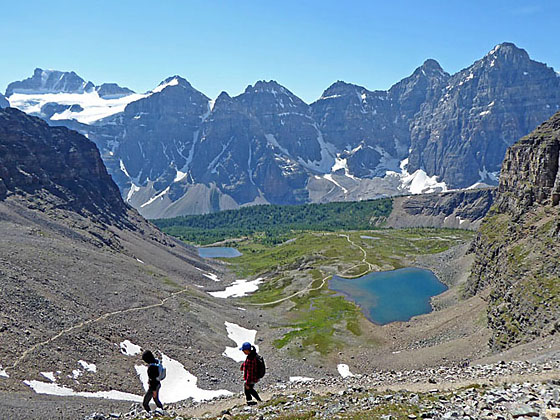
On the southeast side of the bridge the trails ascends south through trees on moderately-easy grades to the northwest shore of lovely Lake Annette (6,447-ft.), cradled in a bowl beneath the dramatic north face of ice-capped Mount Temple, at 3.5 miles. If you’re lucky you may see a chunk of the peak’s glacier break off and tumble down the peak’s steep slopes to snow piles at the base.
Lake Annette is a good destination for families looking for a shorter hike. If this is your destination, enjoy a picnic along the lake shore and then retrace your steps to the trailhead for a 7.0 mile round-trip hike.
For parties continue beyond Lake Annette, the trail turns southwest and ascends to and crosses a rockslide along the slopes of Mount Temple. The open slopes feature breathtaking views of the massive peaks forming the cirque at the head of the valley including Hungabee Mountain (11,156-ft.), Ringrose Peak (10,800-ft.), Glacier Peak (10,768-ft.) and Mount Lefroy (11,292-ft.). Mounts Aberdeen (10,341-ft.) and Haddo Peak (10,072-ft.) dominate the view across the valley to the west while Mount Richardson (10,124-ft.) rises in the distance to the northeast across the Icefield Parkway.
Beyond the slide the trail follows an ascending traverse through larches along the lower slopes of Mount Temple. Opening in the trees offer intermittent views of the high peaks.
At 5.1 miles reach a trail junction. The trail branching right (west), descends to the Giant Steps, a series of photogenic waterfalls, and the Paradise Valley Campground. (Note: The campground is typically closed during July and August due to grizzly bear activity. Check with Banff National Park backcountry office for current information.) We continue straight ahead toward Sentinel Pass and the Larch Valley.
Giant Steps Junction to Sentinel Pass
Distance from Trailhead: 6.9 miles (one way)
Ending/Highest Elevation: 8,566-ft.
Elevation Gain: 2,916-ft.
Reach a second junction at 5.25 miles where we turn left (northeast) toward Sentinel Pass. To the right is another trail descending to the Giant Steps and campground on the valley floor. This is a longer route that swings around the top of Horseshoe meadows and then heads to the Giant Steps. The area around the second junction offers more fine views of the peaks towering above the head of the valley. The viewpoint is another good turn around point for parties that don’t want to climb to Sentinel Pass or descend to the Giant Steps.
To reach Sentinel Pass, follow the trail as it ascends on moderately steep grades through larches and rocky meadows. Soon the grade steepens as the trail climbs through talus and boulder fields along the east side of the valley. The spires and rugged slopes of Pinnacle Mountain loom above the west side of the valley. Ahead is our destination, the saddle atop a scree covered slope at the head of the valley. The pass is located to the right of a rock “thumb” jutting from the scree slopes below the saddle.
In places the trail fades and is difficult to follow, especially if snow is present. The final climb to the pass is up extremely steep scree covered slopes to the pass. If you lose the trail, climb slightly to the right (southwest) of the center of the valley. Your best bet is to watch the route people used when descending from the pass to get back on track. Off the path the footing is not great. Use care. As you approach the top of the pass the trail becomes more evident and the footing improves.
As you crest Sentinel Pass (8,566-ft.) at 6.9 miles amazing views open to the valley of the Ten Peaks. The jagged profiles of eight of the peaks, all over 10,000-ft., fill the skyline to the south. The Fay Glacier lies nestled in the bowl between Mount Fay (10,607-ft.), Mount Little (10,300-ft.) and Mount Bowen (10,076-ft.). The sheer cliffs of Pinnacle Peak form an arc along the southwest side of the pass while the castellated slopes of Mount Temple rise to the northeast. On the bench below the pass lie the Minnestimma Lakes.
Behind you Mount Lefroy, The Mitre, Mount Aberdeen and Haddo Peak in Paradise Valley form the backdrop for the rugged pinnacles lining the rugged valley we ascended to the pass. In the distance Collier Peak (10,545-ft.) and Popes Peak (10,372-ft.) in the Lake Louise Valley are seen through the gap to the right (east) of the The Mitre.
Sentinel Pass to Moraine Lake
Distance from Trailhead: 10.4 miles (one way)
Ending/Highest Elevation: 8,566-ft.
Elevation Gain: -2,383-ft.
After taking in the views, the trail drops steeply down scree covered slopes on the south side of Sentinel Pass to a bench. Here the grade abates as the path travels by the east shore of the first of the small Minnestimma Lakes at 7.6 miles. The lake, set amid meadows and talus slopes, is the perfect place to take a break. From the lakeshore enjoy fine views of the Sentinel Pass trail climbing to the saddle between Mount Temple and Pinnacle Peak. Behind you are panoramic views of the Valley of the Ten Peaks.
Beyond the lake a broad path descends on easy to moderate grades through the Larch Valley’s lovely meadows, accompanied by stunning views of the Valley of the Ten Peaks. From the east to the west the 8 visible peaks are Mount Babel (10,171-ft.), Mount Fay (10,607-ft.), Mount Little (10,300-ft.), Mount Bowlen (10,076-ft.), Mount Yonsa (10,017-ft.), Mount Perren (10,007-ft.), Mount Aleen (10,857-ft.) and Mount Tuzo (10,656-ft.). The last two peaks, Deltaform Mountains (11,230-ft.) and Neptuak Mountain (10,617-ft.) are hidden from view by the ridge extending from Eiffel Peak (10,116-ft.), towering above the west side of the trail.
At 8.2 miles the meadows give way to larch trees with intermittent views of the valley. Views briefly reopen at 8.5 miles as the trail traverses the north side of a long meadow. From the meadows we have our first views of Detaform and Neptuak Mountains at the end of the chain. Eiffel and Pinnacle Mountain rise above the trees to the northwest.
At 8.7 miles the trail plunges back into the trees. Reach the junction with the trail to Eiffel Lake and Wenkchemna Pass, branching sharply off to the right (west), at 9.0 miles. We continue down on the Larch Valley Trail toward the Moraine Lakeshore.
The trail now descends switchbacks on moderately steep grades through spruce-fir forest down the northwest side of the Moraine Lake Valley. At 9.7 miles the trail turns to the northeast and descends to the north end of Moraine Lake near a boat dock at 10.4 miles.
Moraine Lake sits at the foot of a huge cirque formed by the Ten Peaks to the south and Wenkchemna Peak, Eiffel Peak, Pinnacle Mountain and Mount Temple to the west/northwest. The rock pile at the foot of the lake, part of an ancient moraine, is a favorite spot to snap photos of this gorgeous, turquoise lake set against the magnificent backdrop of the Ten Peaks.
When you are done enjoying the views, walk past the boat dock and the Moraine Lake lodge to the parking area, where you hopefully you have a second car waiting.
The Moraine Lake area is one of the most visited spots in Banff National Park. A continual stream of buses drop tourists at the lakeshore, so don’t expect solitude.
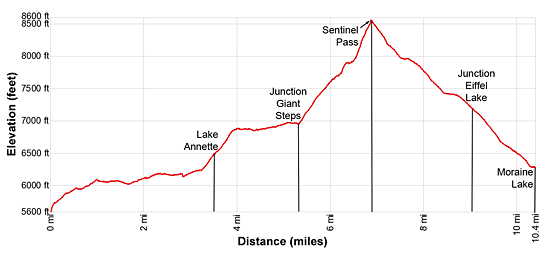
Elevation Profile
Driving Directions
Note: This is a point to point hike requiring a car shuttle or two vehicles. The first vehicle should be left at the Moraine Lake parking area. The party should then drive back to the Paradise Valley parking area to start the hike.
From Lake Louise Village, AB, Canada
To Paradise Valley Trailhead: The Lake Louise Village is located along the Trans-Canada Highway (AB-1). Take the Bow Valley parkway exit toward Lake Louise to reach the hotels and services area.
To reach the trailhead, head west on the Bow Valley Parkway which turns into Lake Louis Drive for 1.4 miles and turn left onto the Moraine Lake Road. Follow the road for 1.5 miles to the Paradise Valley parking area, located on the (right) west side of the road. Note: This is a VERY small parking lot that fills early.
To Moraine Lake Trailhead: The Lake Louise Village is located along the Trans-Canada Highway (AB-1). Take the Bow Valley parkway exit toward Lake Louise to reach the hotels and services area.
To reach the trailhead, head west on the Bow Valley Parkway which turns into Lake Louis Drive for 1.4 miles and turn left onto the Moraine Lake Road. Follow the road for 7.6 miles to the Moraine Lake parking area, located on the end of the road. Note: This is a relatively small parking lot for extremely popular area that fills early in the morning.
From Banff, AB, Canada
To Paradise Valley Trailhead: Head southwest on the Trans-Canada Highway (AB-1 W) for 33.9 miles and then take the Bow Valley Parkway exit toward Lake Louise. Turn left onto the Bow Valley Parkway which turns into Lake Louise Drive for 1.4 miles and then turn left onto the Moraine Lake Road. Follow the Moraine Lake Road for 1.5 miles to the Paradise Valley parking area, located on the (right) west side of the road. Note: This is a VERY small parking lot that fills early.
To Moraine Lake Trailhead: Head southwest on the Trans-Canada Highway (AB-1 W) for 33.9 miles and then take the Bow Valley Parkway exit toward Lake Louise. Turn left onto the Bow Valley Parkway which turns into Lake Louise Drive for 1.4 miles and then turn left onto the Moraine Lake Road. Follow the road for 7.6 miles to the Moraine Lake parking area, located on the end of the road. Note: This is a relatively small parking lot for extremely popular area that fills early in the morning.
From Field, BC Canada
To Paradise Valley Trailhead: Head east on the Trans-Canada Highway (BC-1 E), which turns into AB-1 when it crosses the border into Alberta, for 15.7 miles and then take the Bow Valley exit toward Lake Louise. Turn right, (west) on the Bow Valley Parkway which turns into Lake Louis Drive for 1.4 miles and then turn left onto the Moraine Lake Road. Follow the Moraine Lake Road for 1.5 miles to the Paradise Valley parking area, located on the (right) west side of the road. Note: This is a VERY small parking lot that fills early.
To Moraine Lake Trailhead: Head east on the Trans-Canada Highway (BC-1 E), which turns into AB-1 when it crosses the border into Alberta, for 15.7 miles and then take the Bow Valley exit toward Lake Louise. Turn right (west) on the Bow Valley Parkway which turns into Lake Louis Drive for 1.4 miles and then turn left onto the Moraine Lake Road. Follow the road for 7.6 miles to the Moraine Lake parking area, located on the end of the road. Note: This is a relatively small parking lot for extremely popular area that fills early in the morning.
Trail Resources
Trail Intro / Trail Photo Gallery / Trail Map
Basecamp(s) Information:
Banff / Lake Louise
Region Information:
The Canadian Rockies
Other Hiking Regions in:
Alberta / British Columbia