Details: Plain of the Six Glaciers 
Distance: 8.7 miles (round trip)
Banff National Park, near Banff in The Canadian Rockies
Hike Facts
- Distance: 8.7 miles (round trip)
- Elevation: 5,720-ft. - 7,490-ft.
- Elevation Gain: 1,770-ft.
- Difficulty: moderate-strenuous
- Trail Highlights: See Trail Intro
- Basecamp(s): Banff / Lake Louise
- Region: The Canadian Rockies
Lake Louise and its massive cirque are the stars of this hike highlighting the jaw-dropping scenery of the Lake Louise Valley. The awe inspiring overlook at the end of the hike is surrounded by impressive peaks and glaciers displaying Mother Nature’s raw beauty and power.
To Plain of the Six Glaciers Viewpoint
The hike to the Plain of the Six Glaciers starts on the broad crowded pavement along the east shore of Lake Louise. Here views stretch the length of Lake Louise to Mount Victoria (11,364-ft.), Mount Collier (10,603-ft.) and Popes Peak (10,370-ft.). On a calm morning the high peaks adorned with glaciers are perfectly reflected in the lake’s turquoise waters. This section of the lakeshore is extremely crowded with visitors taking photos of the stunning scene.
Follow the broad walkway as it curves to the left (west) along the lake’s northwestern shore, past the Chateau Lake Louise. After walking 0.2 miles reach a junction and a trailhead sign. Continue straight ahead (west/southwest) on the Lakeshore Trail. The trail branching to the right (northwest) leads to Lake Agnes Tea House, the Little Beehive and the Big Beehive.
The Lakeshore trail is typically crowded with a multitude of strollers. Start your hike early to avoid the crowds.
At 1.4 mile reach the head of the lake where great views extend the length of the lake to the Chateau Lake Louise. A short distance beyond the lake, pass a rock wall popular with climbers.
The path, now referred to as the Plain of the Six Glaciers Trail, ascends the valley on easy to moderate grades, passing the large delta where the glacier’s meltwater stream has deposited gravel and other debris as it flows into Lake Louise. Soon the trail ascends above the creek, traveling through spruce-fir forest and meadows.
After 2.4 miles the trail emerges from the trees to glorious views of the cirque at the head of the valley, anchored by Mount Victoria. Haddo Peak, Mount Aberdeeen, the Miter, Mount Lefroy and the Lefroy Glacier fill the skyline to the south. Below the trail the remains of ancient moraines and a glacial outwash plain, the glacial sediments deposited by the retreating glacier, fill the valley floor.
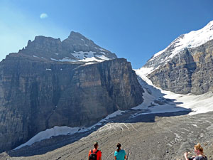
At 2.7 miles the trail passes the junction with the Highline Trail, branching right toward the Big Beehive and Lake Agnes. We continue straight ahead, ascending the Plain of the Six Glaciers trail on moderate grades. The grade abates briefly at 3.0 miles as the trail traverses narrow ledges along a rugged cliff. Beyond the ledges the climb resumes as we briefly travel atop a moraine before ascending to the Plain of the Six Glaciers Tea House at 3.6 miles. Benches and outhouses near the Tea House offer a convenient place to take a break before continuing the hike.
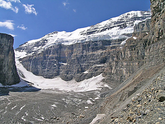
Beyond the Teahouse, the trail traverses the base of a large avalanche chute on the slopes of Pope Peak. Soon the trail starts ascending on moderate to moderately steep grades through stunted conifers and then rocky meadows. Along the way enjoy grand views of Mount Aberdeen, the Lefroy Glacier, the Mitre and Mount Lefroy. Waterfalls fed by glacial meltwater plunge down the sheer slopes.
The final trail segment climbs along a lateral moraine to the overlook at 4.35 miles. Here you are standing below the sheer cliffs of Mount Victoria. The peak soars overhead. Mount Lefroy towers above the valley to the west. The Victoria Glaciers clings to the slopes of Mount Victoria and flows motionlessly down the valley between the peak and Mount Lefroy to the valley floor. Along the valley floor, huge crevasses crisscross the glacier, which is mostly covered with gravel and rock debris.
After enjoying the views, retrace your steps to the trailhead, for an 8.7 mile round-trip hike.
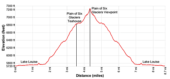
Elevation Profile
Driving Directions
From Lake Louise Village, AB, Canada: The Lake Louise Village is located along the Trans-Canada Highway (AB-1). Take the Bow Valley parkway exit toward Lake Louise to reach the hotels and services area.
Head west on the Bow Valley Parkway which turns into Lake Louis Drive for 2.5 miles and turn left into the Lake Louise Parking area access road. Drive along the road to the reach the lower and upper lot. The walk to the lake is shorter from the lower lot.
During the height of the summer the parking lot near the lake fills early. To reach the lake, park in the Lake Louise Overflow Parking area along the Trans-Canada Highway, located 6 miles south of Lake Louise Village. Regularly scheduled shuttle buses run between the overflow parking are and the lake.
If you are staying in the Lake Louise Village, regularly scheduled shuttle buses run from the Sampson Mall in Lake Louise Village to the lake.
Check the Banff National Park website for the latest information on public transit routes and schedule for more information . ( Link: https://www.banfflakelouise.com/explorethepark/transit-and-shuttles ).
From Field, BC Canada, AB, Canada: – Head east on the Trans-Canada Highway (BC-1 E), which turns into AB-1 when it crosses the border into Alberta, for 15.7 miles and then take the Bow Valley exit toward Lake Louise. Turn right onto Lake Louise Drive and follow the road for 2.5 miles. Turn left into the Lake Louise Parking area access road. Drive along the road to the reach the lower and upper lot. The walk to the lake is shorter from the lower lot.
During the height of the summer the parking lot near the lake fills early. If the parking lot is full you will be directed to the Lake Louise Overflow Parking area, location along the Trans-Canada Highway 6 miles south of Lake Louise Village. Regularly scheduled shuttle buses run between the overflow parking are and the lake.
Check the Banff National Park website for the latest information on public transit routes and schedule for more information . ( Link: https://www.banfflakelouise.com/explorethepark/transit-and-shuttles ).
From Banff, AB, Canada: Head southwest on the Trans-Canada Highway (AB-1 W) for 33.9 miles and then take the Bow Valley Parkway exit toward Lake Louise. Turn left onto the Bow Valley Parkway that turns into Lake Louise Drive. Follow this road for 2.5 miles and turn left into the Lake Louise Parking area access road. Drive along the road to the reach the lower and upper lot. The walk to the lake is shorter from the lower lot.
During the height of the summer the parking lot near the lake fills early. When the lot is full, billboards along the Trans-Canada Highway will direct you to the Lake Louise Overflow Parking area, located 6 miles south of Lake Louise Village. Regularly scheduled shuttle buses run between the overflow parking are and the lake.
Check the Banff National Park website for the latest information on public transit routes and schedule for more information . ( Link: https://www.banfflakelouise.com/explorethepark/transit-and-shuttles ).
Trail Resources
Trail Intro / Trail Photo Gallery / Trail Map
Basecamp(s) Information:
Banff / Lake Louise
Region Information:
The Canadian Rockies
Other Hiking Regions in:
Alberta / British Columbia