Details: Cottonwood Lakes 
Distance: 11.6 - 12.4 miles (round trip)
John Muir Wilderness Area, Inyo National Forest, near Lone Pine in California's Southeastern Sierra
Hike Facts
- Distance: 11.6 - 12.4 miles (round trip)
- Elevation: 10,070-ft. - 11,140-ft.
- Elevation Gain: 1,070-ft. - 1,267-ft.
- Difficulty: moderate
- Trail Highlights: See Trail Intro
- Basecamp(s): Lone Pine / Bishop
- Region: California's Southeastern Sierra
This popular hike visits a series of scenic lakes set amid pretty meadows and framed by a wall of granite peaks and ridges, anchored by Mt Langley.
Trailhead to Cottonwood Lakes
Distance from Trailhead: 11.6 miles (round trip)
Ending/Highest Elevation: 11,140-ft.
Elevation Gain: 1,207-ft.
The Cottonwood Lakes trail heads northwest through pine forest, ascending a small rise on gentle grades. Along the way pass the boundary for the Golden Trout Wilderness. After hiking a little over 0.5 miles the trail curves to the north, tops a low rise and then descends on ease grades to a crossing of the South Fork Cottonwood Creek at 1.4 miles.
Rock hop across the creek and follow the trail as it drops ever so slightly into the Cottonwood Creek valley. At 1.8 miles the trail begins ascending the valley on easy grades, staying to the west of the creek. Occasional breaks in the tree offer views of the granite cliffs lining the west side of the valley.
Trees give way to a long narrow meadow with your first view of Cottonwood Creek at 2.5 miles. A fence across the upper end of the meadow marks the border of the Golden Trout Camp, owned and operated by the Thacher School. The trail skirts the west side of the meadow, briefly reenters the trees and then travels along the western edge of a second meadow, staying to the west of the camp’s property, whose structures can be seen through the trees on the east side of the creek.
The trail now starts curving to the west and enters the John Muir Wilderness at 3.0 miles. Shortly after the wilderness sign the trail crosses Cottonwood Creek on a wood log. Beyond the creek the grade steepens as the path traverses along the northeast side of another large meadow with views of a rocky ridge rising along the south side of the valley.
Reach the junction with the trail to New Army Pass at 3.5 miles. Turn right on the trail to Cottonwood Lakes. The path branching to the left leads to New Army Pass and South Fork Lakes.
The trail now climbs steeply up a dry, forested hillside above the north side of the creek, crossing a draw with a small stream along the way. Openings in the trees offer good views to the southwest of the peaks and ridges along the Sierra Crest.
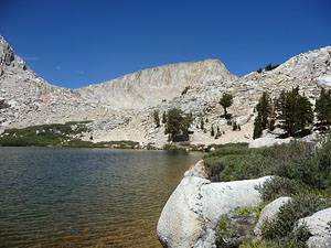
Near the top of the climb reach the junction with the trail to Muir Lake heading right (northwest), 4.5 miles from the trailhead. Shortly beyond the junction the trail crests the eastern rim of the Cottonwood Lakes Basin in a large meadow with great views of Mount Langley (14,027-ft.) rising to the northwest. Cirque Peak (12,900-ft.) dominates the skyline to the southwest.
The trail heads west, wandering through the meadow on easy grades. To the southwest Cottonwood Lake #1 comes into view, set amid a huge meadow and framed by Cirque Peak and its adjoining ridges. Toward the end of the meadow the trail veers northwest, ascending a forested hillside on moderate grades.
At the top of the hill the grade levels as the trail travels along the southwestern side of a large meadow, passing a shallow willow lined tarn and small cabin along the way. Mt. Langley dominates the skyline to the northwest.
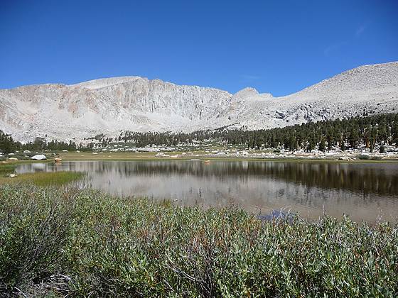
Near the head of the meadow the trail turns west and descends to the northeastern shore of Cottonwood Lake #3, 5.8 miles from the trailhead. A rugged granite peak towers above the lake’s southwestern shore. The rocky, willow-lined northeastern shore is covered with scattered pines and harbors some nice campsites. A use trail runs along Lake #3 northeastern shore and then travels between Lakes #2 and Lake #1, ultimately connecting to the trail to New Army Pass.
The scenic lakes basin invites exploration and is a great place to lie in the sun and soak in the views. Just remember that you have a long hike back to your car.
To Lakes #4 and #5
Distance from Trailhead: 12.4 miles (round trip)
Ending/Highest Elevation: 11,200-ft.
Elevation Gain: 1,267-ft.
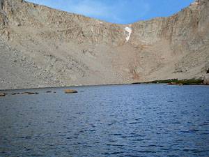
To reach Cottonwood Lakes #4 and #5, follow the trail that contours around the lake’s northern shore and then ascends along the east side of the inlet stream, reaching the narrow isthmus separating Lakes #4 (11,186-ft.) and #5, 6.2 miles from the trailhead.. These two alpine jewels are nestled beneath the sheer cliffs on the ridge to the south of Mt. Langley. The extremely steep unmaintained trail to Old Army Pass is located at the southwest end of Cottonwood Lakes #4 and is used by parties climbing Mt. Langley.
Backpackers will find nice campsites along the southeastern shore of Lake # 4 and a few campsites along the northeastern of Lake #5. Be advised this is a very popular area and there is a lot of competition for the limited number of overnight camping permits issued by the forest service. I recommend backpackers plan ahead and request a permit as soon as they become available. See the Inyo National Forest Wilderness Permits page for more information.
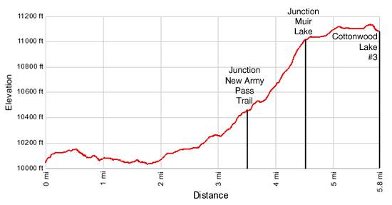
Elevation Profile
Driving Directions
From Lone Pine: From US Highway 395 in Lone Pine, CA, turn west on Whitney Portal Road. Travel along the road for 3 miles and turn left (south) on Horseshoe Meadow Road. Follow the paved road for 19.2 miles, climbing a series of switchbacks to an intersection with Cottonwoods Lakes / New Army Pass, branching to the right. Turn right and travel along the Cottonwood Lakes / New Army Pass road for 0.5 miles to the hiker parking lot. (Continuing straight at the intersection leads to Horseshoe Meadow and the trailheads for Cottonwood Pass / Trail Pass.)
From Bishop: Drive south on Highway 395 for 57.4 miles to Lone Pine, CA and turn west on the Whitney Portal Road. Travel along the road for 3 miles and turn left (south) on Horseshoe Meadow Road. Follow the paved road for 19.2 miles, climbing a series of switchbacks to an intersection with Cottonwoods Lakes / New Army Pass Road, branching to the right. Turn right and travel along the Cottonwood Lakes / New Army Pass road for 0.5 miles to the hiker parking lot. (Continuing straight at the intersection leads to Horseshoe Meadow and the trailheads for Cottonwood Pass / Trail Pass.)
Trail Resources
Trail Intro / Trail Photo Gallery / Trail Map
Basecamp(s) Information:
Lone Pine / Bishop
Region Information:
California's Southeastern Sierra
Other Hiking Regions in:
California