Details: West Snowmass 
Distance: 12.4 miles (round trip)
Maroon Bells-Snowmass Wilderness, White River National Forest, near Aspen in Central Colorado
Hike Facts
- Distance: 12.4 miles (round trip)
- Elevation: 8,400-ft. - 11,780-ft.
- Elevation Gain: 3,380-ft.
- Difficulty: strenuous
- Trail Highlights: See Trail Intro
- Basecamp(s): Aspen
- Region: Central Colorado
Solitude, a good workout and nice views, along with a chance to see wildlife, are the rewards for hikers of this lightly used trail ascending steeply to the saddle separating the Snowmass and Capitol Creek Valleys.
Trailhead to the Pass
Distance from Trailhead: 12.4 miles (round trip)
Ending/Highest Elevation: 11,780-ft.
Elevation Gain: 3,380-ft.
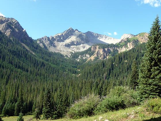
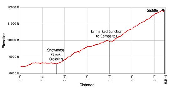
The trail to West Snowmass Pass initially follows the Maroon-Snowmass trail. From the trailhead (see driving directions) the Maroon-Snowmass Trail ascends on moderate grades through aspen and mixed conifers, following the arc of the Snowmass Creek drainage as it heads southwest. Openings in the trees provide views of Snowmass Creek meandering along the valley floor to the west of the trail.
After gaining 200-ft. in 0.5-miles the grade levels for the next mile. Reach the junction with the West Snowmass trail at 1.5-miles. At the junction the West Snowmass trail turns right and drops down to Snowmass Creek on a long switchback. Depending on the time of year the cold and swift creek varies from knee to ankle deep. Sandals are recommended to protect your feet while negotiating the large slippery rocks in the creek bed.
Across the creek the trail ascends on moderate grades through a large meadow and then enters a forest of aspen and mixed conifers. Soon after entering the trees the trail comes to a gated fence marking the beginning of National Forest land. Beyond the fence the trail climbs switchbacks up a hillside, high above the north side of West Snowmass Creek.
At 2.6 miles the path drops to cross a minor drainage then resumes its ascent. The grade abates a bit at 3.0 miles as the trail nears the creek, traveling through forest interspersed with pretty meadows.
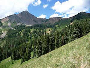
At 4.0 miles reach an unmarked junction at a large meadow with wonderful views of Clark Peak and Mt. Daly (13,300-ft.). The prominent trail to the left (south) descends through the meadow to nice campsites along West Snowmass Creek. We bear right (west) on a trail that ascends steeply through forest and meadows up the hillside beneath Haystack Mountain (12,206-ft.). As you climb the trees thin yielding ever improving views of the surrounding peaks.
Reach at trail junction at 5.0 miles. Here the Nickelson Creek trail heads right. We bear left at the junction, continuing the climb up the steep hillside. Good views of Mt. Daly and the peaks to the south and southeast distract you from the stiff ascent.
At 5.6 miles the trail enters a large grassy basin on the south flank of Haystack Mountain. Follow the trail as it climbs steeply, swings right (north) and then left (west) to reach the saddle (aka West Snowmass Pass) at the top of the ridge between Haystack Mountain and Mt. Daly at 6.2 miles.
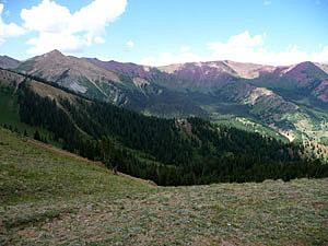
From the saddle views extend southeast to the high peaks of the Maroon Bells-Snowmass Wilderness. To the west, the red rock peaks lining the Capitol Creek drainage extend northwest to Mt. Sopris (12,953-ft.).
The pass is a good turnaround point for day hikers. After taking in the view retrace your steps to the trailhead.
Junction with the Capitol Creek Trail
Distance from Trailhead: 8.4 miles (one way)
Ending/Highest Elevation: 10,050-ft.
Elevation Gain: -1,730-ft.
Beyond the saddle the trail drops off the ridge and makes a steep descent through seldom visited meadows and forest to the junction with the Capitol Creek trail at 8.4 miles, providing options for extended overnight loop trips combining the Snowmass and Capitol Creek valleys.
Backpackers should keep in mind that after crossing Snowmass Creek the West Snowmass Trail climbs 3,000-ft. in 4.5 miles to the saddle and then loses 1,750-ft. in 2.2 miles. This is not an easy trail when carrying a full pack.
Elevation Profile
Buy the BookThis opinionated guide includes all the hikes in the Aspen, Buena Vista, Crested Butte, Marble and Leadville sections of the website plus info on local services and nearby attractions. | |

Driving Directions
Driving Directions from Aspen:
Option 1 (Rough, steep and narrow road for part of the drive): Drive 6 miles west of Aspen on Highway 82 and turn left on the Brush Creek Road (the main road to Snowmass Village). Continue on Brush Creek Road for 5.5 miles through Snowmass Village and then turn right on Divide Road.
Divide Road turns into a gravel road and passes the Krabloonik Restaurant and Kennels. The rough road descends steeply to the bottom of the Snowmass Creek valley where it forks. Take the left fork. Pass the East Snowmass trailhead on the left. Continue another 0.2 miles to the Maroon-Snowmass Trailhead, which is also the starting point for the West Snowmass Trail, at the end of the road. When parking, please do not block the gate leading to the ranch at the west end of the parking lot.
Note: there is limited parking at the trailhead. The trailhead, popular with backpackers traveling to Snowmass Lake, can get quite crowded on the weekends.
Option 2 (Better option for 2WD vehicles): Drive 14 miles west of Aspen on Highway 82 to Old Snowmass and turn left on the Capitol Creek/Snowmass Creek Road (next to the Conoco Gas station on the south side of the highway). Continue 2 miles to a "T" intersection. Turn left and follow Snowmass Creek Road (CO Rd. 11) for 5.8 miles to a fork in the road. Take the left fork, staying on Snowmass Creek Road (CO Rd. 11) for 3.4 miles to a “T” intersection. Take a right. Soon you will pass the East Snowmass trailhead on the left. Continue another 0.2 miles to the Maroon-Snowmass Trailhead, which is also the starting point for the West Snowmass Trail, at the end of the rough road. When parking, please do not block the gate leading to the ranch at the west end of the parking lot.
Note: there is limited parking at the trailhead. The trailhead, popular with backpackers traveling to Snowmass Lake, can get quite crowded on the weekends.
Trail Resources
Trail Intro / Trail Photo Gallery / Trail Map
Basecamp(s) Information:
Aspen
Region Information:
Central Colorado
Other Hiking Regions in:
Colorado