Details: Silver Run Plateau 
Distance: 11.8 miles (round trip)
Absaroka Beartooth Wilderness, Custer National Forest, near Red Lodge in Beartooth Mountains
Hike Facts
- Distance: 11.8 miles (round trip)
- Elevation: 7,625-ft. - 10,600-ft.
- Elevation Gain: 2,975-ft.
- Difficulty: moderate-strenuous
- Trail Highlights: See Trail Intro
- Basecamp(s): Red Lodge
- Region: Beartooth Mountains
This interesting and scenic hike ascends through the Silver Run Lakes basin and then climbs atop the Silver Run Plateau, an amazing tundra-clad expanse of rolling terrain over 10,000-ft. The first 2.75 miles of the hike follow the Timberline Trail through a burn area.
Trailhead to Silver Run Plateau
There are several ways to access the Silver Run Plateau. In my opinion this route, which uses a portion of the Timberline Lake (#12) and Bear Track (#8) trails is the easiest and most scenic.
The trail starts at the southwest end of the Timberline Lakes trailhead. (See driving directions below.) The trail climbs up the south side of the West Fork Rock Creek valley on moderate to moderately-steep grades. Two long switchbacks facilitate the ascent through an area burned by the 2008 Cascade Fire, which is slowly making a comeback.
Fireweed and small evergreens grows among the decaying snags. As the snags fall views are opening to the surrounding peaks.
At 1.2 miles the grade eases a bit as the trail curves to the right (south/southwest) into the Timberline Creek Valley. Intermittent views through the dead snags open to the 10,000-ft. peaks rising along the ridge rimming the east side of the valley and to the Silver Run Plateau rising above the head of the valley.
At 2.75 miles the trail curves to the left (southwest), crosses a minor creek and then reaches a junction with the Bear Track trail (#8) at 2.8 miles. Here the Timberline trail turns right (southwest) and continues southwest to Gertrude and Timberline Lakes. We bear left (southeast) on the Bear Track trail, which soon crosses to the east side of Timberline Creek. Logs and rock in the creek bed will help keep your feet dry. Early in the season you will need to wade across the creek.
At 3.3 miles we leave the burn area behind. The path now ascends on moderate grades through spruce-fir forest, crossing to the east side of the outlet stream for the Silver Run Lakes at 3.5 miles. After the snow melts you can rock hop across the stream. Early in the season you will probably need to wade across the creek.
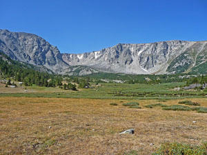
Pass the boundary of the Absaroka Beartooth Wilderness at 3.6 miles. Soon the trail curves to the right (south) and travels through trees and meadows along the bases of the rocky slopes of the Silver Run Plateau. From the meadows views open west to marshy meadows and the Silver Run Lakes basin. The photogenic cliffs below the plateau form a beautiful backdrop for the pretty basin.
As you ascend the basin the trees give way to meadows with ever expanding views of the Silver Run Lakes and the cirque of rugged cliffs towering above the head of the basin.
At 4.5 miles the trail curves to the left (east) as the trail starts climbing moderately-steep to steep switchbacks up the rugged slopes leading to the plateau. As you ascend enjoy birds-eye-views of the lake basin and the cirque. From this perspective you can see down the Timberline Creek Valley where the pattern of the burn is quite evident. Towering above the valley to the west is an arm of the Silver Run Plateau.
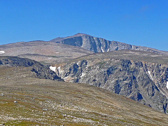
At 5.3 miles the grade moderates as to trail tops the plateau and now ascends through a vast expanse of alpine tundra. To the west the summit of Silver Run Peak (12,500-ft.) rises above the plateau.
On a nice day the plateau is an incredible place with views stretching for long distances across the rolling terrain. Few people climb the plateau so you are likely to have this amazing place to yourself.
Soon the trail fades and large rock cairns mark the path across the plateau. At 5.7 miles the trail approaches the high point (10,600-ft.) on the trail. To the southwest views open to the distinctive summits of Mount Rearguard (12,204-ft.), Spirit Mountain (12,283-ft.) and Beartooth Mountain (12,377-ft.). Whitetail Peak (12,548-ft.), a triangular-shaped peak, rises to the southwest of Silver Run Peak. Closer at hand are the summits atop the plateau.
At this point I recommend finding a nice place to take in the views and then retracing your steps to the trailhead for an 11.8 miles round-trip hike.
Beyond the high point the Bear Track trail follows a series of rock cairns as it gently descends across the tundra and then drops down extremely steep grades to the Bear Track Trailhead along Highway 212, 8.4 miles south of Red Lodge. Total distance from the high point on the plateau to the highway is about 9.4 miles. This makes the point-to-point hike between the Timberline Trailhead to the Bear Track trailhead a 15.3 miles journey. A car shuttle is required.
It is also possible to use a combination of the Ingles Creek Trail #35 and the Silver Run Plateau trail #64 to descend from the Bear Track Trail the West Fork road, 5.6 miles east of the Timberline Trailhead. The total distance for this point-to-point hike, which also requires a car shuttle, is 13.6 miles.
The point-to-point hikes are best done as a backpack, spending the first night in the Silver Run Lake Basin and then getting an early start the next morning to cross the high plateau before the onset of afternoon thunder storms, a frequent occurrence in the Rocky Mountains.
Keep in mind there is no water and no cover atop the plateau in the event of a storm. Keep an eye on the weather and descend from the plateau if a storm is approaching. Always carry water.
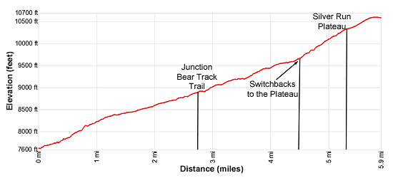
Elevation Profile
Driving Directions
From Red Lodge, MT: From the middle of downtown Red Lodge head south on US 212 W (S Broadway Ave). At the south end of town turn right on the West Fork Road (signed for the Red Lodge Ski area). Follow the road for 2.8 miles to a fork. To the right is Ski Run Road. Bear left to stay on the West Fork Road. Follow the road for 8.4 miles and turn left into the signed Timberline Creek trailhead parking area. (Note: After the fork the road is paved for 4.6 miles and then turns gravel.)
Trail Resources
Trail Intro / Trail Photo Gallery / Trail Map
Basecamp(s) Information:
Red Lodge
Region Information:
Beartooth Mountains
Other Hiking Regions in:
Montana